We are excited to share our latest highlights from the Columbia World Project, ACToday. During a period marked by global upheaval and tragedy caused by the COVID-19 pandemic, we have been especially inspired to keep our work on track. We are proud of how quickly our country teams were able to adapt to the realities of the day and make outstanding progress.
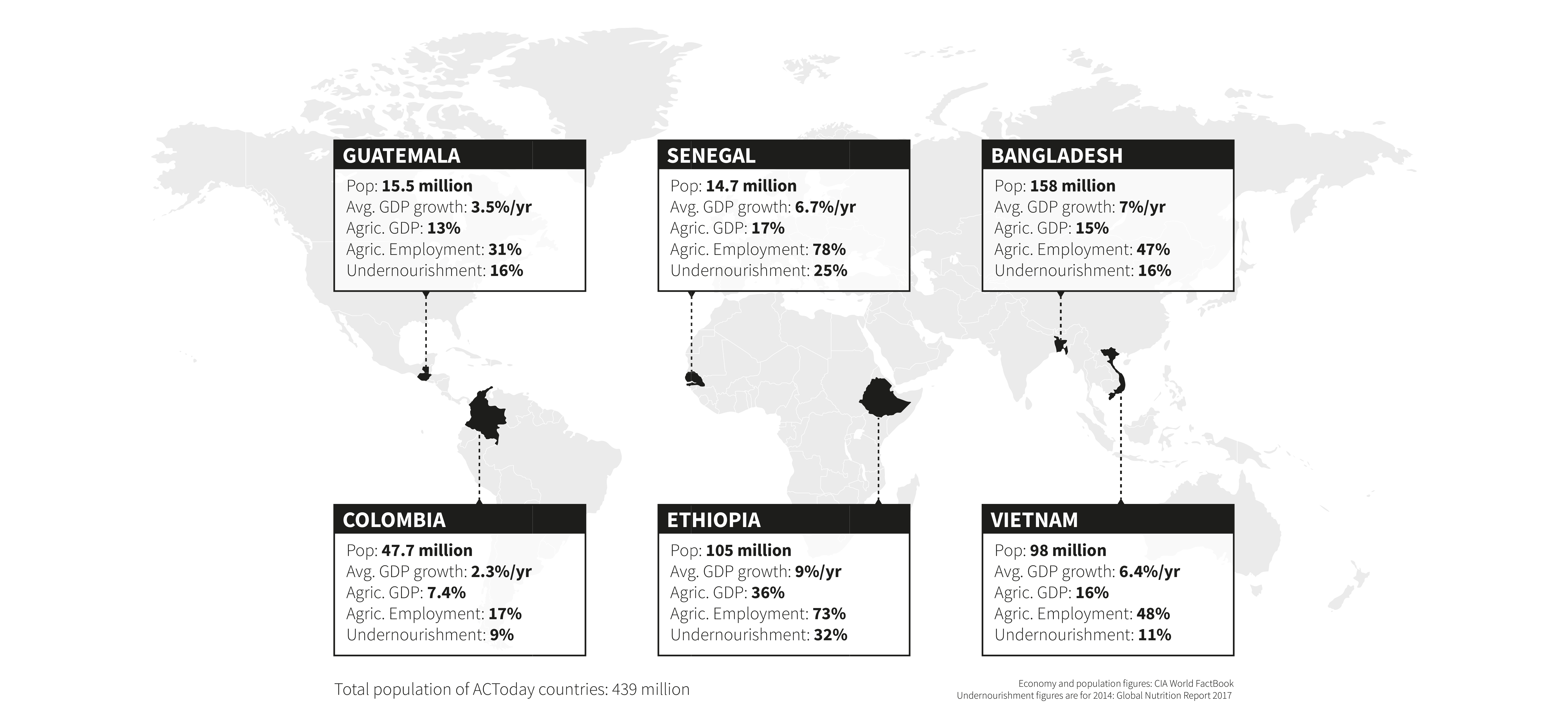
ACToday remains focused on its goal of combating hunger by increasing climate knowledge in six countries that are particularly dependent on agriculture and vulnerable to the effects of climate change and fluctuations: Bangladesh, Colombia, Ethiopia, Guatemala, Senegal and Vietnam.
But the stories featured in this report underscore something larger: that the successes of our work are now leading to opportunities for us to go beyond the six project countries, and scale at regional levels and draw in new partners.
This is not an accident.
Through trainings and co-development of scientific and technical tools, our country teams have strengthened the capacities and capabilities of national meteorological services, enabling them to better meet the needs of the public and private sector institutions they serve. This in turn has bolstered their reputations and has led to increased demand for their services, not only in the food-security community but also in energy, public health and other sectors. In a similar fashion, ACToday teams are training staff within national ministries, agriculture extension services and research institutions to become more sophisticated users of climate information for decision making. These are foundational changes, ones that will continue to transform approaches to achieving food security in each country long after the ACToday project ends.
The climate services we’re building together bring decades of science and experience directly to bear on decisions the governments of each project country make when it comes to the wellbeing of their people.
University President Lee C. Bollinger launched Columbia World Projects in hopes of fulfilling a ‘Fourth Purpose’ of universities: supporting activities that focus the university’s research, expertise and resources to develop real and sustainable solutions for some of society’s most intractable problems.
A key word here is ‘sustainable’, which is why from the start, ACToday has focused on maintaining strong national and international partnerships based on trust and collaboration. The climate services we’re building together bring decades of science and experience directly to bear on decisions the governments of each project country make when it comes to the wellbeing of their people. Our efforts are leading to real change, and our successes have garnered the attention of neighboring countries and the international community.
As the COVID-19 pandemic reminds us: when good science is allowed to inform policy, all of society benefits.
Lisa Goddard and Walter Baethgen
International Research Institute for Climate and Society
Since its launch in 2017, ACToday has invested in forecasts, monitoring tools and other information products to help government agencies, humanitarian organizations and farmers better plan for droughts and other climate-related threats to food production.
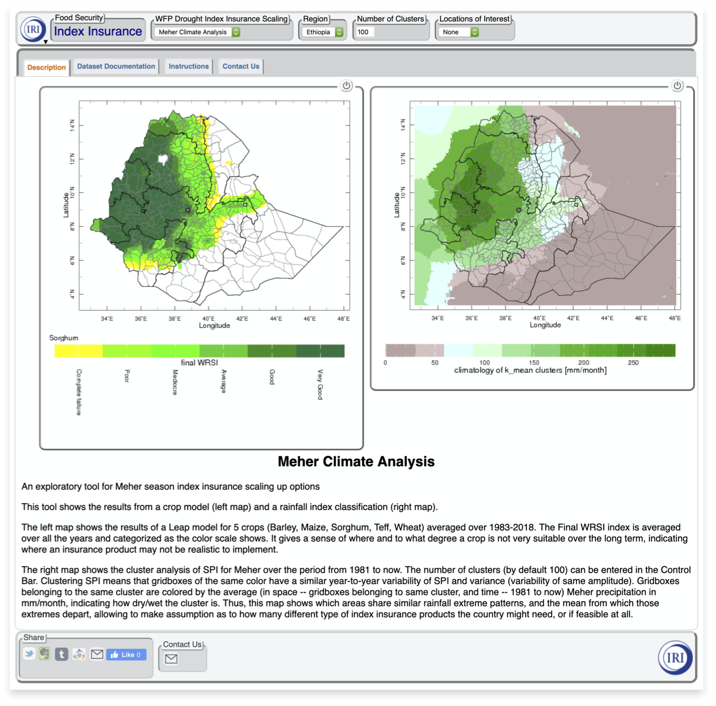
These tools, which are an important component of climate services, are now directly enabling the World Food Programme (WFP), winner of the 2020 Nobel Peace Prize, to reach its target of providing a million smallholder farmers in Ethiopia with affordable index-based insurance against droughts and other climate risks.
Index insurance is an innovative, affordable type of insurance that’s tied to a measurement of weather, such as rainfall estimated by satellites or recorded at a local weather station. If the amount of rainfall during critical stages of a crop’s growth cycle doesn’t reach a pre-specified threshold, farmers who purchased the insurance automatically get compensated without having to file any claims. This innovation has significantly lowered the transaction costs and risks for insurance companies, enabling them to keep premiums low and helping millions of farmers access coverage previously unavailable to them.
During times of drought, insurance helps farmers and their families keep food on the table. In non-drought years, insurance coverage helps farmers feel safe to take out loans to buy fertilizer and other inputs that can significantly increase their yields and income. Research by the International Research Institute for Climate and Society (IRI) and other organizations have shown that insured farmers in Ethiopia accumulated almost double the level of savings that their non-insured counterparts did, and also invested more in seeds, fertilizer and assets such as oxen.
A screenshot of a new maproom developed by ACToday to help the World Food Programme scale its index insurance program to reach more farmers in Ethiopia.
Both WFP and the World Bank are using ACToday tools to expand their index insurance programs in Senegal and Ethiopia (countries where ACToday is operating) as well as in Malawi, Zambia and Mozambique.
“ACToday helped us create the conditions for a major scale up in these countries by giving local insurance experts the capacity to design insurance products tailored to their area of coverage,” said Mathieu Dubreuil, Insurance Advisor at WFP. “This was an essential step that allowed us to expand into new regions and reach much bigger numbers of participants.”
The design tool Dubreuil refers to is a new ACToday maproom–a mapping platform powered by the IRI’s Data Library. It helps insurance experts visualize rainfall patterns over wide areas, allowing them to pool insurance contracts for multiple areas based on these patterns, as opposed to making different contracts for each area.
“Previously, we would decide where to expand insurance based just on where the poorest farmers were,” said ACToday insurance expert Rahel Diro. “But these aren’t necessarily the places where insurance would have the most benefit for the most people. The maproom allows us to pinpoint these areas.”
“ACToday helped us create the conditions for a major scale up in these countries by giving local insurance experts the capacity to design insurance products tailored to their area of coverage. This was an essential step that allowed us to expand into new regions and reach much bigger numbers of participants.”
Mathieu Dubreuil, Insurance Advisor at WFP
Such a platform–which delivers crop information, high-resolution climate forecasts, historical rainfall data and satellite observations, all in real time–wouldn’t have been possible without the infrastructure and services ACToday built and continues to support through its collaboration with national meteorological services.
Keeping the Focus on Farmers
How farmer-driven index insurance can help manage climate risks and make them more resilient and productive.
“We know from our decades of experience that index-insurance programs can’t scale up successfully if they don’t include farmers in the design process,” said Daniel Osgood, an economist at the International Research Institute for Climate and Society who is working on ACToday.
“Farmers are the only ones who truly understand their risks and opportunities, and whether or not the meteorological data on which the insurance index is based is accurately reflecting their crop losses,” he added. “They must have a solid understanding of which risks the insurance covers and doesn’t cover, or else they might make adaptation choices that would leave them unknowingly exposed.”
The process of working with farmers to develop responsible insurance products normally requires frequent community visits–a workable approach for projects covering a few dozen to a few hundred villages, but one that is too effort-intensive for projects that want to reach thousands or hundreds of thousands of farmers.
“We’re reducing the need for the insurance teams to visit every community, while still being able to crowdsource indispensable data from thousands of farmers.”
Daniel Osgood, IRI
Working with WFP and the World Bank in Senegal, ACToday has piloted new tools that allow farmers to use phone technology to participate in the design and verification of the index insurance being considered for their village. Farmers can share information via text messages, online forms, phone apps or by automated phone surveys asked in local languages. These tools are also, as part of ACToday, being tested across the Atlantic, in Colombia, where rice farmers in the Meta region are sending feedback to insurance providers working with Fedearroz, the country’s federation of rice producers.
“We’re reducing the need for the insurance teams to visit every community, while still being able to crowdsource indispensable data from thousands of farmers,” Osgood said. “This is also enabling insurance programs to continue despite the travel restrictions and other challenges brought on by the COVID-19 pandemic.”
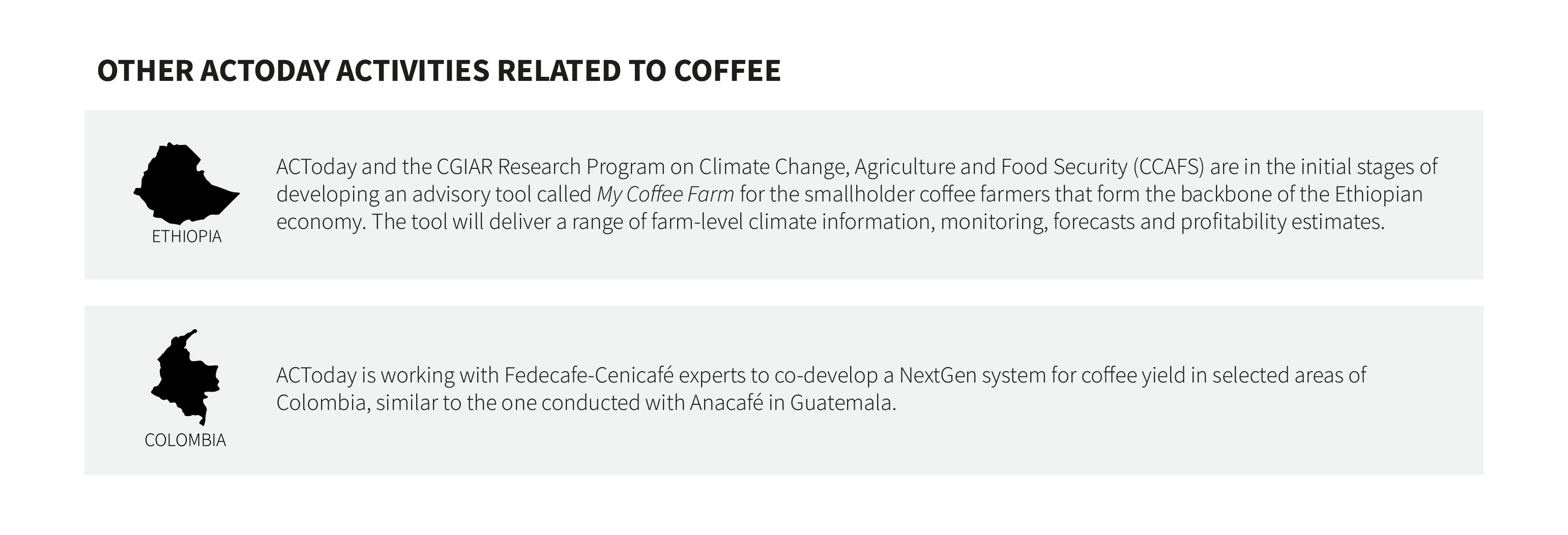
ACToday operates in four of the top ten coffee-producing countries in the world: Colombia, Ethiopia, Guatemala and Vietnam. Minimizing climate risks to coffee production is a strategic component of ACToday’s goal of improving food security for hundreds of thousands of farmers who depend on the crop for income. A closer look at our work in Vietnam and Guatemala shows how ACToday is supporting this important sector.
Coffee is a big business in Vietnam, the world’s second largest producer, which exported more than $2.4 billion worth of the crop in 2019. Although coffee is not a food crop, its production plays a significant role in the food security of many communities who depend on the crop as a primary source of income.
Climate variability and change pose a growing threat, as rising temperatures and extreme weather subject farmers to increasing uncertainties: longer droughts, more frequent floods and severe outbreaks of pests and diseases that result in reduced productivity.
To help Vietnam’s coffee farmers adapt to these climate-driven changes, ACToday is creating a new digital app that delivers location-specific climate information and growing-season advisories that can help farmers maximize yields and reduce operating costs.
“The collaboration builds on our partnership with MARD, which is strongly interested in providing improved climate services and economic support to Vietnam’s coffee farmers,” said John Furlow, the country lead for ACToday in Vietnam.
“Our goal was to customize, translate and connect climate information to profitability and costs at the farm level.”
J. Nicolas Hernandez-Aguilera, IRI
The highest costs Vietnamese coffee farmers incur are for fertilizers, fuel to run irrigation pumps and labor. Climate uncertainty can drive these costs even higher. For example, to protect their yields against unpredictable extreme weather events or droughts, farmers might end up using much more water and fertilizer than is necessary, wasting precious resources, labor and money.
“Our goal was to customize, translate and connect climate information to profitability and costs at the farm level,” said J. Nicolas Hernandez-Aguilera, an economist who helped develop ACToday Coffee.
The app will provide growers with customized information to help them with farm-level management and planning decisions. Farmers will be able to calculate, for example, the lowest amount of fertilizer and water they need to use to maximize coffee yields for their specific growing region, said Hernandez-Aguilera.
Eighty percent of Vietnam’s coffee is grown in the Central Highlands region, home to 47 out of 54 of the country’s ethnic minority groups. Coffee is a main source of income for many of these groups.
“Coffee revenues contribute about 30% to the region’s gross domestic product,” said Tran Cong Thang, Director General of Vietnam’s Institute of Policy and Strategy for Agriculture and Rural Development. “Coffee production has helped to raise incomes and reduce poverty within the ethnic minority communities, which face many difficulties.”
The Vietnam team hopes to pilot ACToday Coffee in mid-2021.
On the opposite side of the planet, Guatemala’s coffee farmers share the same worries about the sustainability of their livelihood as do their counterparts in Vietnam. Guatemala consistently ranks in the top ten producers of coffee in the world and exports nearly $1 billion of the crop each year, according to the Food and Agriculture Organization.
As in Vietnam, climate change, droughts and excessive rainfall events are posing increasing threats to coffee yields in Guatemala.
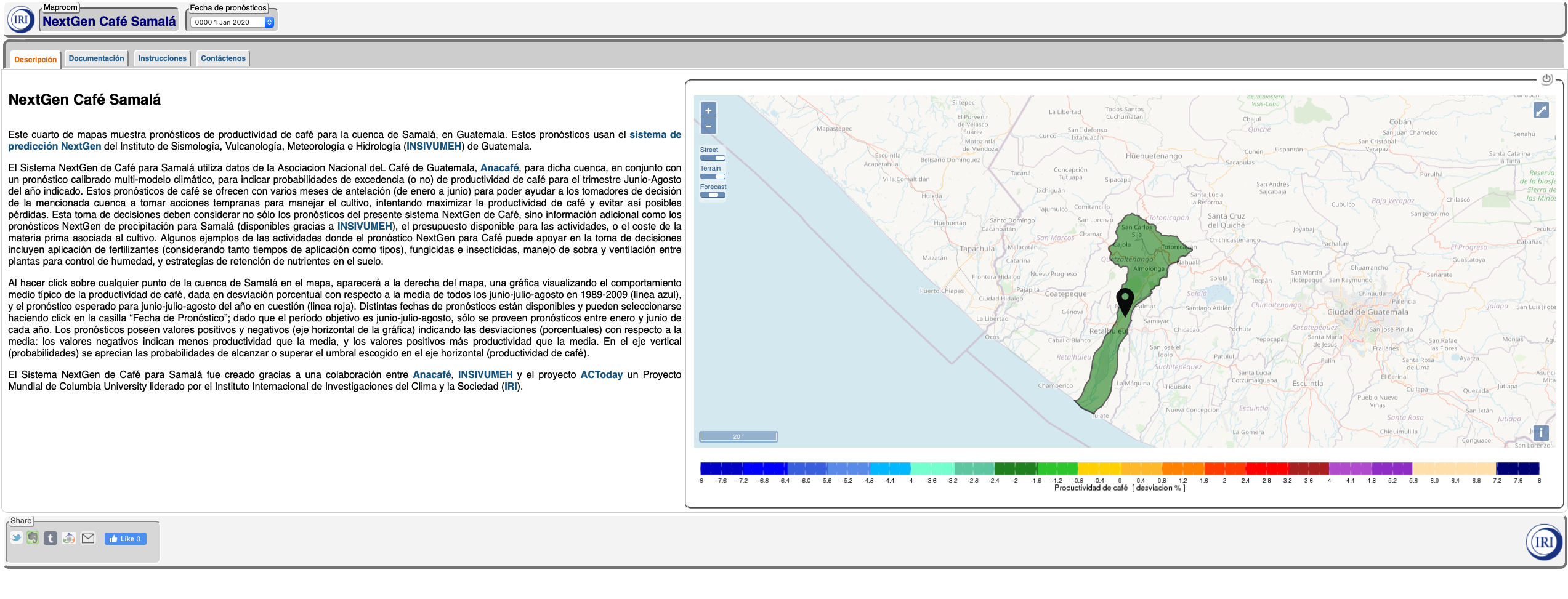
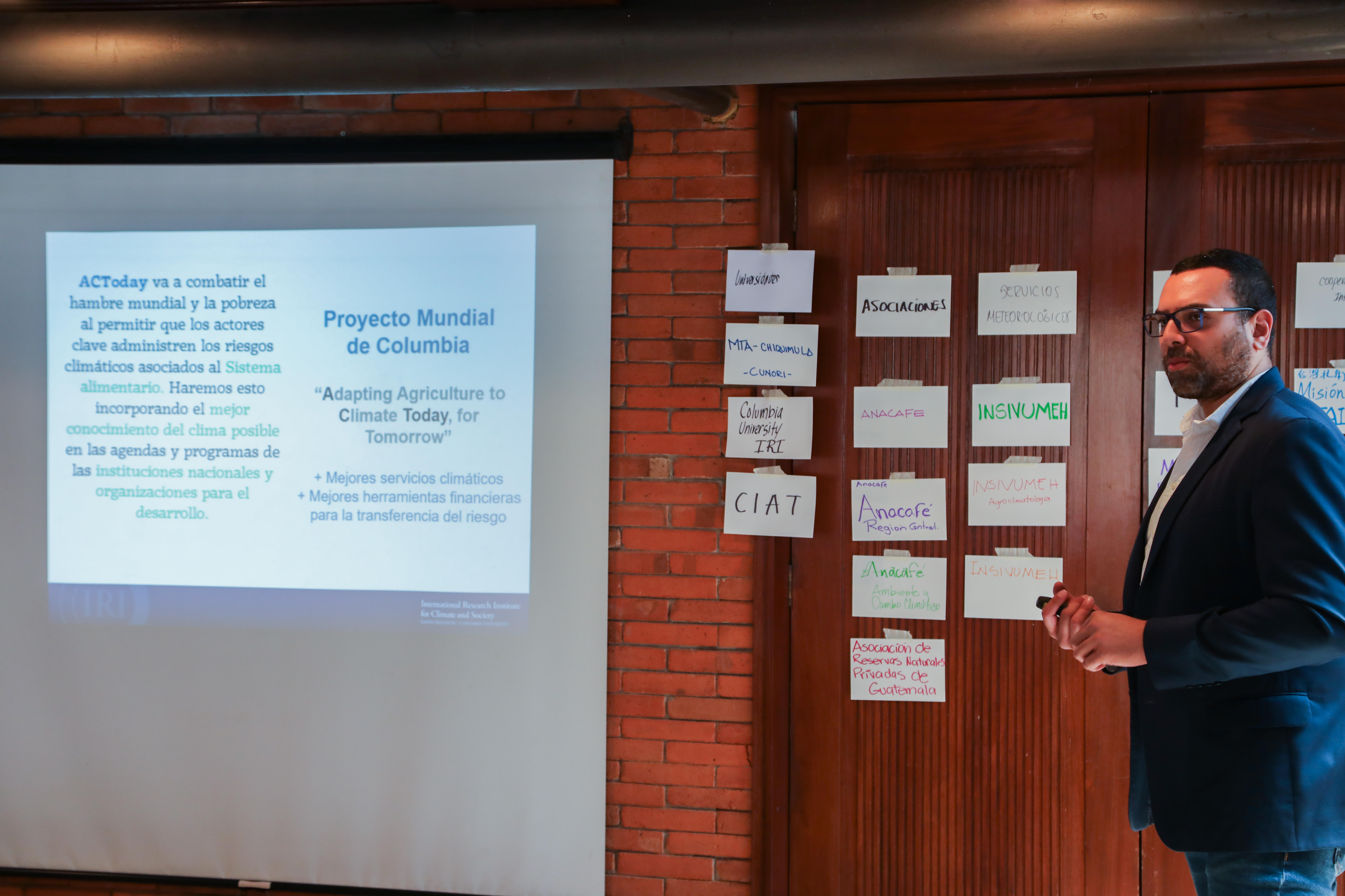
Similar to the efforts it is making in Vietnam, ACToday has developed a platform that will help Guatemala’s 125,000 coffee growers improve their farm-management practices and ultimately help them calculate predicted crop yields based on local climate forecasts. To create and test the system, ACToday partnered with Guatemala’s national coffee association, Anacafé, a trade group that works on behalf of all the country’s coffee producers,from large plantations to smallholder farmers. Anacafé is expected to roll out the decision-support platform nationwide by the end of 2021.
“We’re finding that one of the key ways to improve food security in Guatemala is to help reduce climate risks related to coffee production, given the importance of this crop in the economy of the country, thereby protecting an important income stream for families.”
Carmen González Romero, IRI
“Anacafé will be able to generate estimated yields based on what the climate is likely to do, and issue tailored recommendations to different growing regions.” said Carmen González Romero, ACToday country manager for Guatemala and Colombia. “A capability at this level has never existed before.”
The new platform stems from ACToday’s ongoing collaboration with Guatemala’s national meteorological service, INSIVUMEH.
“We observed that the forecasts issued by INSIVUMEH were increasingly specific and accurate since ACToday began working with the meteorological service,” said Ligia Mariela Meléndez Pérez, an agroclimatologist at Anacafé. “We’re excited to translate these new capabilities into information our farmers can use to improve their productivity and manage climate risks. Anacafé has a responsibility to provide the best available climate services for our coffee growers.”
A screenshot of Anacafé’s NextGen decision-support platform co-developed with ACToday and INSIVUMEH.
Nearly 97% of Guatemala’s coffee is grown on smallholder farms. Annually, the coffee sector generates around half a million direct and indirect jobs.
“We’re finding that one of the key ways to improve food security in Guatemala is to help reduce climate risks related to coffee production, given the importance of this crop in the economy of the country, thereby protecting an important income stream for families,” said González Romero.
The forecasting service ACToday is building with Anacafé will help thousands of farmers stay competitive in a challenging, highly globalized market.
“Good yields can often mean the difference between their families having enough to eat or not,” added González Romero.
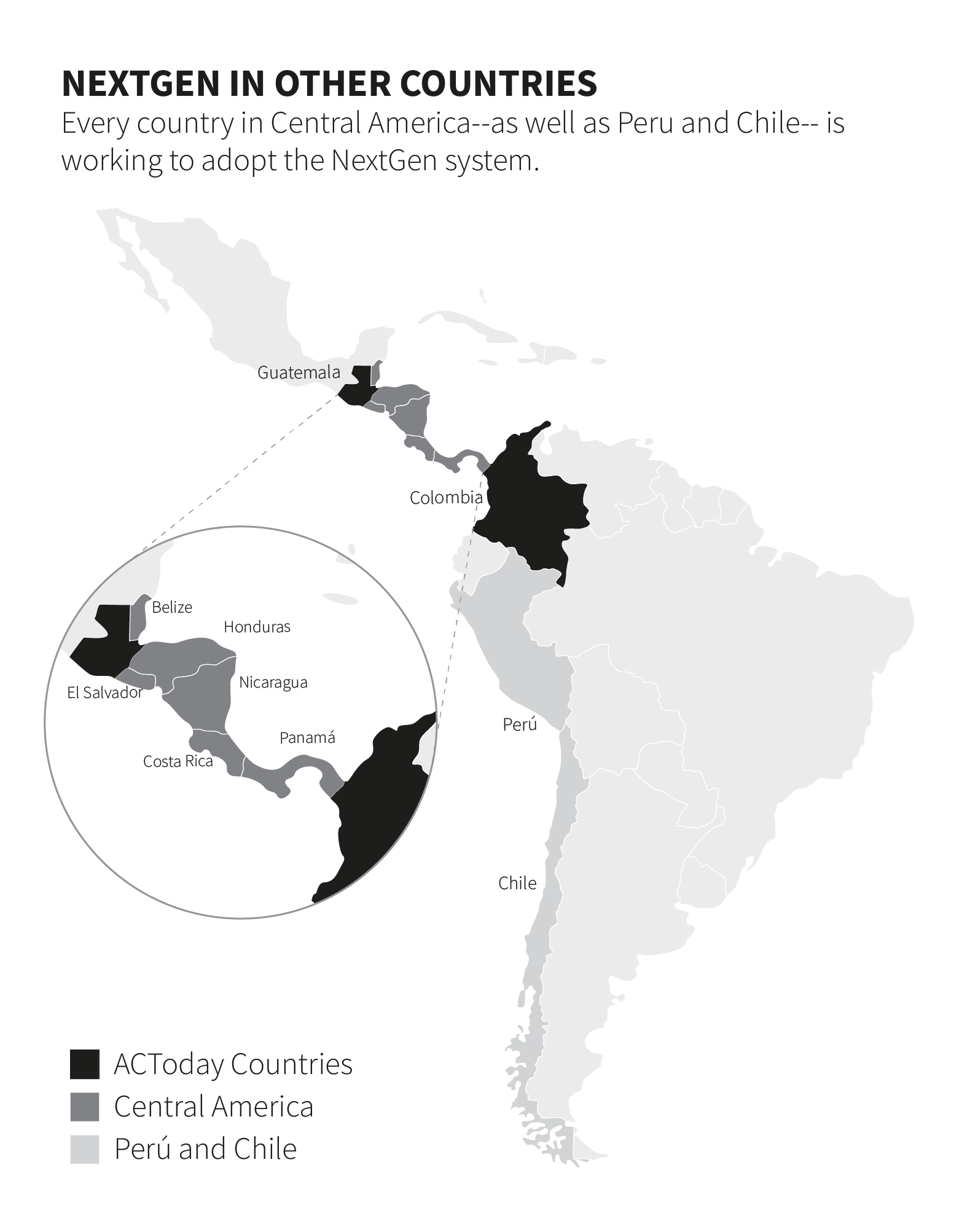
ACToday has worked with the national governments of all six countries where the project operates to design and deploy a state-of-the-art forecasting system known as NextGen. In 2019, NextGen was launched in Colombia and Guatemala. The new forecast approach gave the two countries a significant upgrade to their climate prediction capabilities almost overnight, and has enabled the development of more sophisticated decision-support systems, including mapping tools, for agriculture and food-security planning.
Neighboring countries have paid attention to ACToday’s successes in Colombia and Guatemala, leading to an exciting development in 2020: Every country in Central America,as well as Peru and Chile,is working to adopt the NextGen system.
“Food security transcends boundaries,it doesn’t recognize national borders,” said Ángel G. Muñoz, the ACToday country lead for Colombia and Guatemala. “So when we improve the capability of an entire region to monitor and forecast climate conditions that could impact food production, storage, transport and trade, all the countries, and the 150 million people who live in them, benefit.”
The decision to implement NextGen in these new countries came after a meeting of the Board of Directors of the Central American Regional Committee of Hydrological Resources (CRRH), said Muñoz. The directors of the region’s seven national meteorological services make up the board.
“ACToday was invited to present NextGen to CRRH, and when we showed them the system’s forecasting and verification capabilities, one-by-one, each country gave us the green light to implement it,” he said.
“When we improve the capability of an entire region to monitor and forecast climate conditions that could impact food production, storage, transport and trade, all the countries, and the 150 million people who live in them, benefit.”
Ángel Muñoz, IRI
“We’re proud to see how the Central American meteorological services are implementing NextGen using a regional approach rather than a country-by-country one,” said Berta Olmedo, CRRH’s executive secretary. “These countries share similar demands for food security, similar expertise and resources, and similar climate risks. The NextGen system enables them to take advantage of each other’s experience to develop a state-of-the-art regional system that provides tailored information at national and subnational levels.”
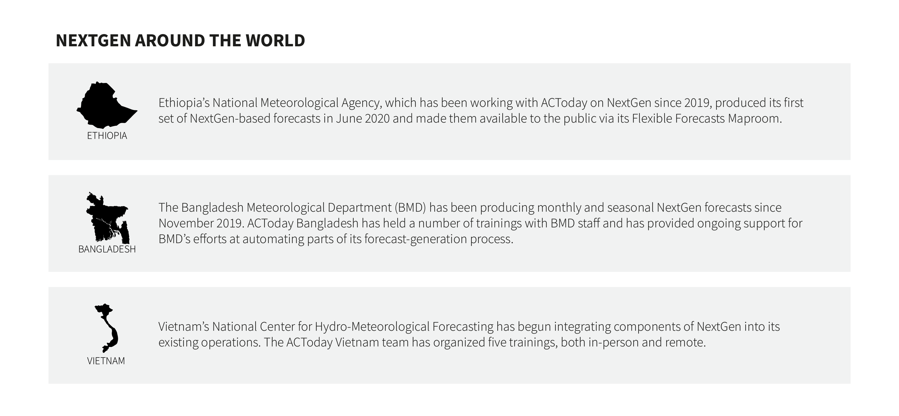
Despite the COVID-19 pandemic, ACToday has continued its work, conducting a set of virtual NextGen trainings for each country’s national meteorological service. Staff from INSIVUMEH, Guatemala’s meteorological service and a key ACToday partner, are leading the training sessions, which include representatives from all the participating countries.
“They’re learning the fundamentals together, sharing ideas and working through decisions and problems as a team, and for the whole region, independently of the country they are from,” said Muñoz. “We consider this an important step in building a strong, long-lasting NextGen community in the region.”
“NextGen has an incredibly flexible approach for producing spatially-detailed and seamless predictions at timescales of weeks to years,” said Wilfran Moufouma-Okia, the head of WMO’s Regional Climate Prediction Services Division. “It provides new avenues for delivering high-quality climate information, products and services that benefit decision makers.”
WMO is supporting the expansion of NextGen into Chile and Peru through its existing climate services project called ENANDES, which aims to increase the adaptive capacity of highly vulnerable Andean communities in these two countries and in Colombia. Moufouma-Okia said the decision came after he and his WMO colleagues saw the positive impacts of ACToday’s collaboration with IDEAM, Colombia’s national meteorological service.
“NextGen has an incredibly flexible approach…that provides new avenues for delivering high-quality climate information, products and services that benefit decision makers.”
Wilfran Moufouma-Okia, WMO
“What’s really exciting is that as more countries implement NextGen, we’re helping change the way individual national meteorological services work because we’re able to take a regional approach to training and collaboration,” said Muñoz.
“Advances in one country often end up informing and guiding the trajectory of one or more of its neighbors through technical cooperation and knowledge sharing across countries in the Southern Hemisphere, he said.
ACToday relied on its strong, collaborative partnerships with country partners when the COVID-19 pandemic struck and all international travel ceased. Two examples from Bangladesh and Vietnam show how country teams quickly adapted to a new, virtual reality and keep the project momentum going.
In early 2020, as the realities of the COVID-19 pandemic began to play out, the government of Bangladesh instituted work and travel restrictions across most of its agencies.
These restrictions applied to everyone but essential staff working in Bangladesh’s Meteorological Department, the agency that publishes critical weather and climate information used by decision makers across the country.
“We could work online at a time when almost the whole world was locked down, and when our forecasts were most needed by Bangladeshis to inform their agricultural planning.”
Quamrul Hassan, Bangladesh Meteorological Department
Yet despite these limitations due to the quarantine, the meteorology department’s staff was able to continue issuing monthly climate forecasts for the country, thanks to the tools and training enacted through its partnership with ACToday.
“From the beginning of the project, one of our goals was to increase the in-house forecasting capacity of the national meteorological service so that it could provide the best information possible for agriculture and food-security planning and prioritization,” said Mélody Braun, the Bangladesh country lead for ACToday.
By the time the pandemic struck, ACToday had trained meteorology department staff on how to implement state-of-the-art forecasting and verification methods, and later worked with them to automate a number of key but time-consuming steps in the forecast-production process.
Nachiketa Acharya, Simon Mason and other climate scientists at the International Research Institute for Climate and Society helped the meteorology department develop specialized scripts to download thousands of new weather observations each month, run multiple climate models, and even automatically generate an initial set of forecasts that the department could evaluate.
“They used to do most of this manually. We helped make it a much less labor-intensive process,” said Acharya.
All the work done by ACToday in Bangladesh ahead of the pandemic meant that from the onset of the COVID-19 quarantine restrictions, forecasters were set up to execute the scripts remotely, thus avoiding any major interruptions to their forecasting operations when they could no longer work in their offices. Throughout the quarantine, Acharya, who speaks Bengali, provided support when it was needed via interactions on Facebook Messenger and late-night phone calls.
“These were the critical months that preceded the summer monsoon season, which is so vital to the country’s crop production and food security,” he said, of the pandemic’s early days. “I knew what was at stake.”
“The experiences in Bangladesh and Vietnam help remind us that ACToday’s collaboration-focused approach with its partners around the world can result in wonderful outcomes, even in very challenging times. It was deeply motivating.”
Walter Baethgen, IRI
“We could work online at a time when almost the whole world was locked down, and when our forecasts were most needed by Bangladeshis to inform their agricultural planning,” said Bangladesh Meteorology Department forecaster Quamrul Hassan.
In Vietnam, similar efforts had been underway to help the country’s National Centre for Hydro-Meteorological Forecasting (NCHMF) move to a more automated process of making climate forecasts. When the COVID-19 lockdowns started, the ACToday team was finalizing plans to conduct staff training sessions at the NCHMF offices in Hanoi.
“We had to adapt quickly to keep the momentum going,” said IRI’s Simon Mason. To do this, he and Dannie Dinh, the deputy country lead for ACToday Vietnam, converted what would have been multiple days-long, in-person trainings to shorter virtual ones.
Each day for three weeks, Mason and Dinh hosted 2.5-hour Zoom sessions for NCHMF staff, teaching them how to make and evaluate state-of-the-art forecasts using the NextGen system that ACToday has implemented in all six project countries.
“We spent most of the online sessions discussing theory, going through examples and interpreting forecast results on the fly,” said Mason. “And the participants would spend the rest of their day–while we got some sleep!–running their own exercises, so that when we met again, we could focus on answering any questions they had. It worked out quite well.”
As a result of those trainings, the NCHMF team was able to produce monthly and seasonal NextGen forecasts, which they distributed to other government agencies and to the broader public for use in decision making.
“Moving quickly to online meant we could cover all the basics and be ready to work with NCHMF to develop an automated forecasting system in the coming year,” said Dinh. “We could do that because of the solid, trust-based relationship we built with the center’s staff in the prior two years.”
“The experiences in Bangladesh and Vietnam help remind us that ACToday’s collaboration-focused approach with its partners around the world can result in wonderful outcomes, even in very challenging times,” said Walter Baethgen, the co-lead of ACToday. “It was deeply motivating.”
Produced by the IRI Communications Team
For more information about ACToday, please visit iri.columbia.edu/actoday. To support work like this, please email ACToday[at]iri.columbia.edu. For more information on Columbia World Projects, visit www.worldprojects.columbia.edu
Click on the image below to download a PDF version of this report.
University President Lee C. Bollinger launched Columbia World Projects in 2017 to bring university research out into the world in the form of projects that tackle some of society’s most intractable problems. His message to the university community was simple:
Aim to be bold and make a significant and lasting difference in people’s lives.
What follows in this report are highlights from the first project to take on President Bollinger’s call to action: Adapting Agriculture to Climate Today, for Tomorrow (ACToday). ACToday is working in six countries— Bangladesh, Colombia, Ethiopia, Guatemala, Senegal and Vietnam—to help meet the U.N.’s Sustainable Development Goal 2: ending hunger, achieving food security, improving nutrition and promoting sustainable agriculture. These countries are home to nearly 450 million people, many of whom are chronically undernourished because they depend largely on rainfed agriculture for the food they grow, eat and sell. Ultimately, climate variability is an ever-present threat to their lives and wellbeing.
ACToday is working to improve food security in two ways: by increasing the production and availability of state-of-the-art climate information products and tools, and by improving the way such information is used for decision making, planning and policy related to agriculture and food.
This approach is based on two decades of experience and leadership of Columbia’s International Research Institute for Climate and Society (IRI). Since 1996, IRI has implemented science-based solutions for adaptation planning and climate risk management in public health, agriculture and other sectors in more than two dozen countries.
As a Columbia World Project, ACToday works closely with national government agencies and institutions within each country. Our activities also tie into existing programs and goals set forth by our international partners, including, for example, the CGIAR Research Program on Climate Change, Agriculture and Food Security (CCAFS), the World Food Program (WFP), the Food and Agriculture Organization (FAO) and the World Bank. By working closely with these and other global institutions in the six ACToday countries, we are helping them to better manage climate risks and opportunities across their programs. In this way, we can truly create long-lasting and intergenerational benefits for the millions of people at risk of hunger and malnutrition each year.
We believe the key to ACToday’s success lies in the strength of our external partnerships.
ACToday combines IRI’s knowledge with that of faculty and students from the School of International and Public Affairs, the Earth Institute, the Institute of Human Nutrition and the Center for Sustainable Investment, leveraging their expertise on nutrition, food policy and international development; yet Columbia’s expertise and reach can only take us so far. We believe an essential key to ACToday’s success lies in the strength of our external partnerships.
We’re excited to share some of the accomplishments and hard work of our ACToday country teams and partners.
Lisa Goddard and Walter Baethgen
International Research Institute for Climate and Society
Co-Leads of ACToday
Delivering the Next Generation of Climate Forecasts
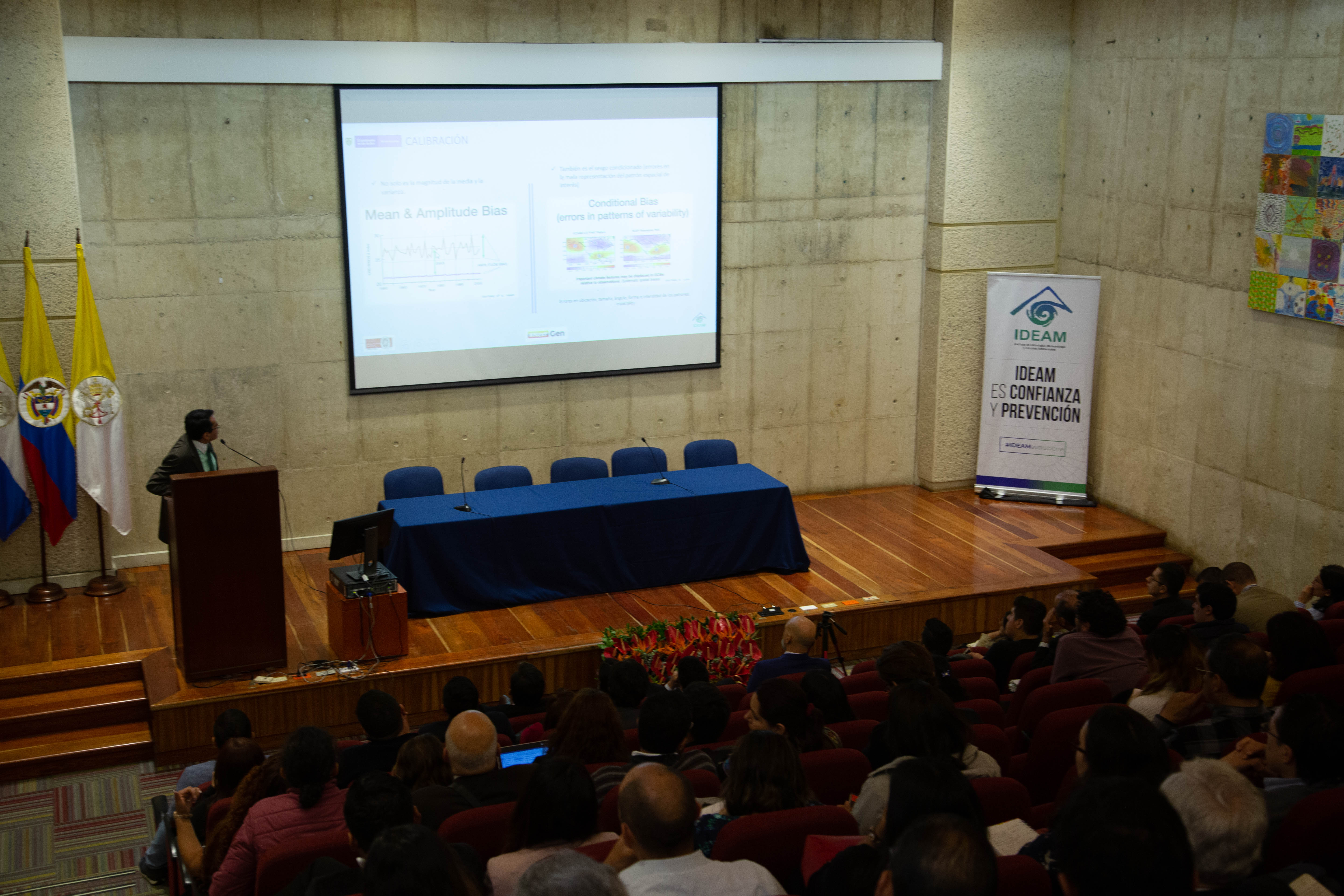
In August of 2019, Colombia’s national meteorological service, IDEAM, launched a state-of-the-art climate forecasting system called NextGen. One month later, Guatemala’s weather service, INSIVUMEH, did the same. The launch events were the culmination of nearly two years of collaboration between ACToday and national agencies of both countries.
José Franklyn Ruiz, the Head of Weather and Climate Modeling Group for the National Meteorological Service of Colombia, presents at the NextGen launch event on August 13th, 2019. Photographer Jacquelyn Turner, ACToday/IRI.
NextGen is a system for analyzing data, calibrating climate models and verifying forecasts based on a suite of climate tools developed by the International Research Institute for Climate and Society. The new system gives Colombia and Guatemala a powerful upgrade to their forecasting capabilities, and enables them to provide their institutions—and citizens—an unprecedented caliber of climate information for decision making in agriculture, public health and other sectors.
“NextGen is helping us create better forecasts for the actual critical thresholds of interest for the agriculture, water management, health and energy sectors in Colombia.”
Yolanda González Hernández, Director of IDEAM
“We know that in order to make policies and decisions that effectively manage climate risks in their food systems, countries need access to reliable data and the ability to produce skillful forecasts—that’s where NextGen comes in,” said Lisa Goddard, ACToday’s Co-Director. “And under ACToday, we also want to help build the capabilities of national institutions to produce such information locally, using their data and their technical staff. In this way, they become invested in NextGen’s success.”
NextGen allows IDEAM and INSIVUMEH to create forecasts tailored to different sectors, and in a flexible format so that particular climate variables of interest may be assessed.
“For example, imagine you’re a farmer whose maize crop needs at least 90 mm of rainfall around the flowering stage,” said Ãngel Muñoz, who oversees ACToday’s work in Colombia and Guatemala. “It’s important for you to know the likelihood of getting at least that amount. If the probability is low, then you can choose to plant a different crop, or make other farm-level decisions.”
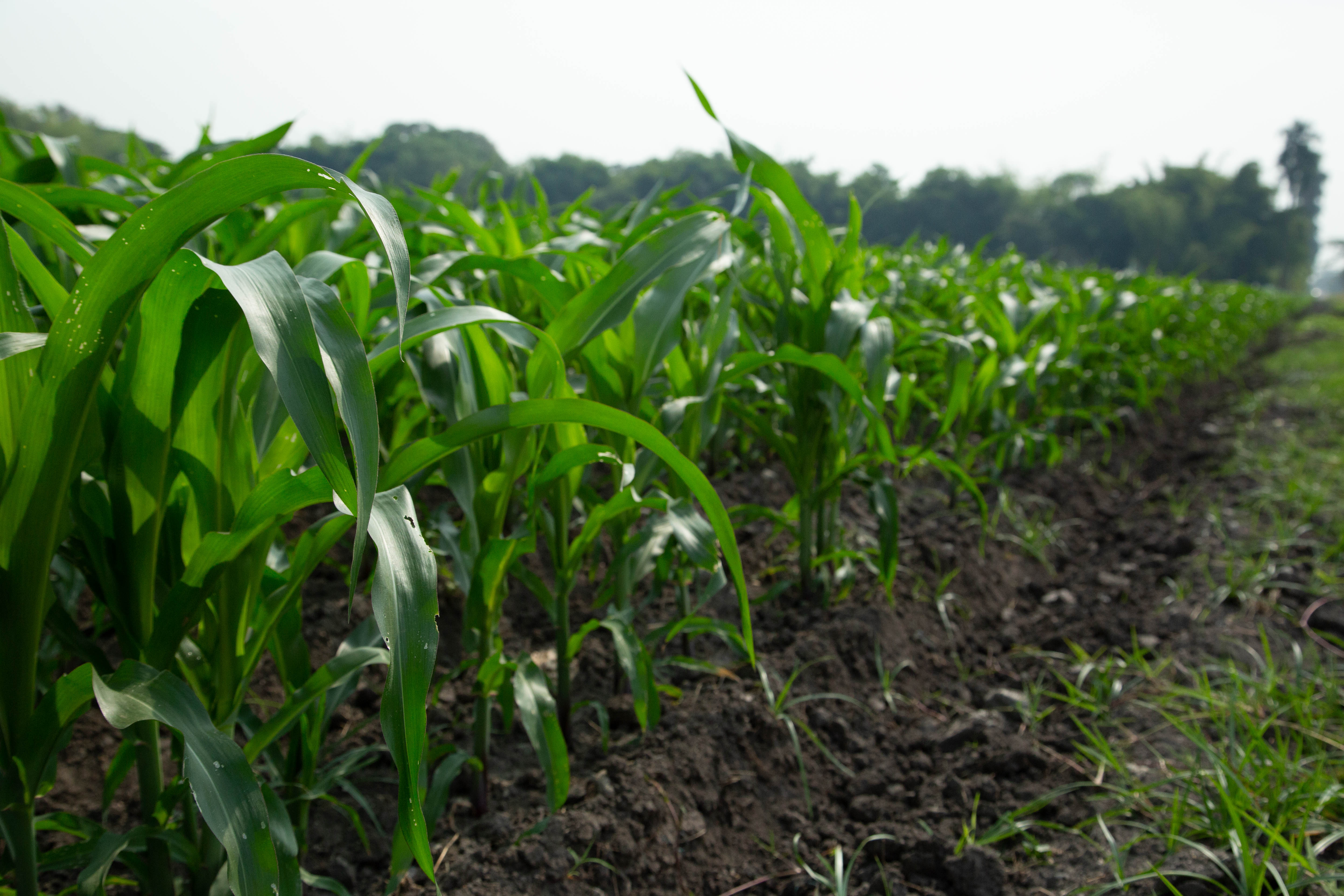
A row of young corn plants at the International Center for Tropical Agriculture (CIAT) in Cali, Colombia. Photographer Jacquelyn Turner, ACToday/IRI.
The most common seasonal forecasting systems today provide only the probability of getting “above-normal”, “normal”, or “below-normal” amounts of rainfall for an area, Muñoz said. “But what exactly does that mean for different crops?”
NextGen’s flexible forecast interface allows users to enter any rainfall amount and see what the probability of getting at least that amount for the upcoming growing season is. Users can also calculate the frequency of rainy days, the duration of dry spells, as well as minimum, maximum and mean temperatures.
“NextGen will help make Guatemala a leader in the region when it comes to climate forecasting. This is a historic step forward for the country. It will now be able to provide climate services not just to some, but to all Guatemalans, especially those who depend on rainfed agriculture for food and income,” said ACToday’s Diego Pons, who works on the project’s Guatemala team.
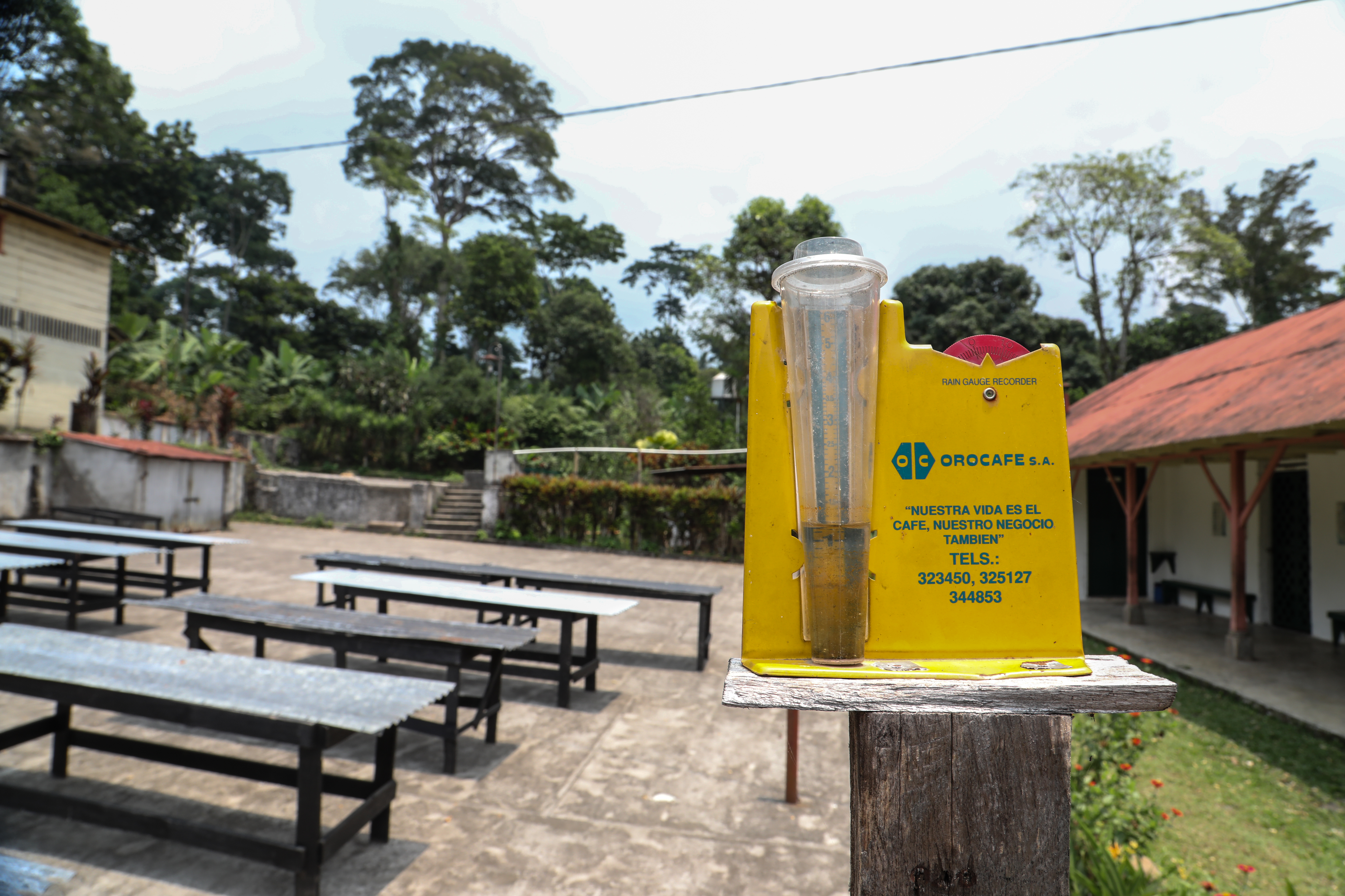
A rain gauge at a coffee farm in Guatemala. Photographer Elisabeth Gawthrop, ACToday/IRI.
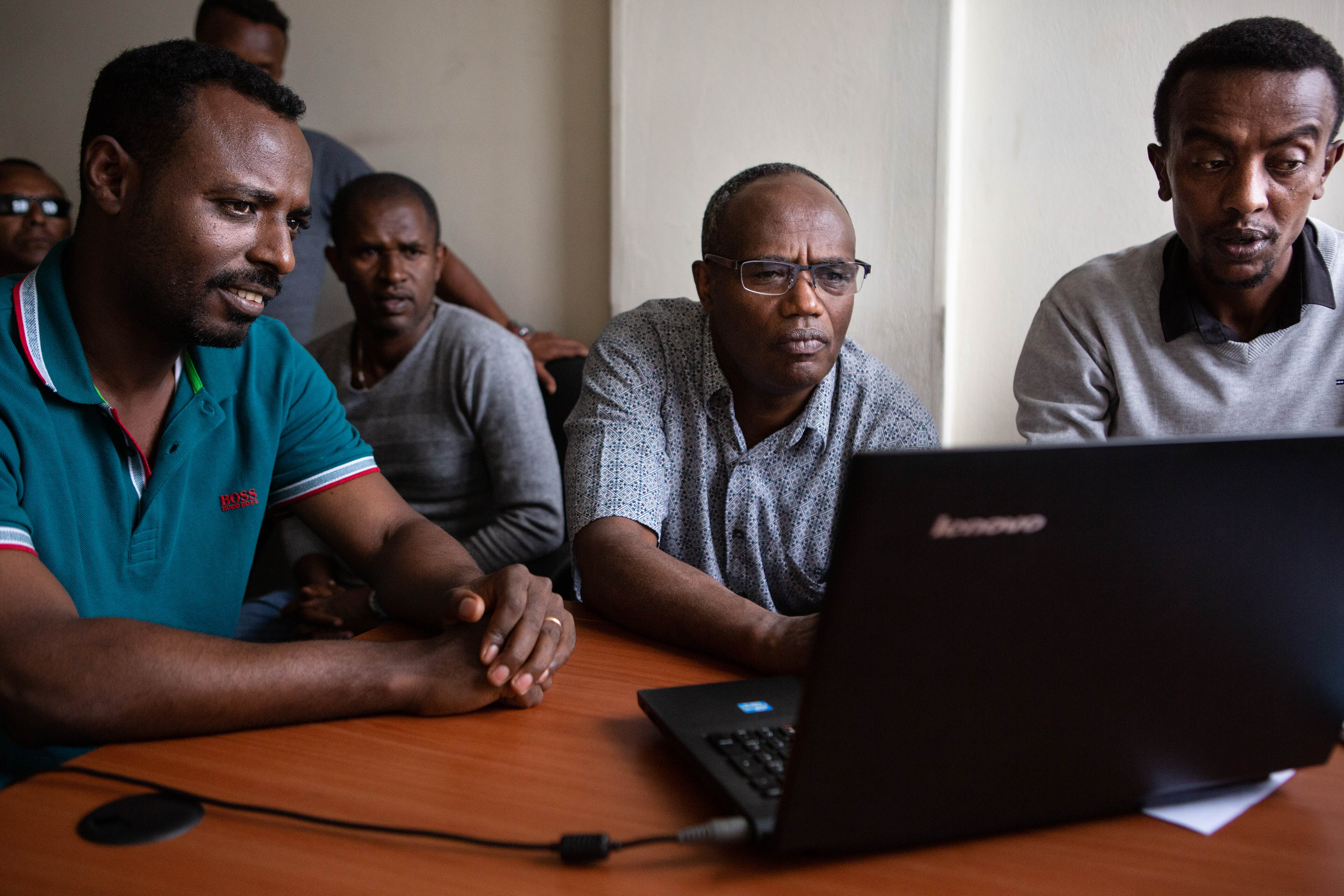
Training Agents of Change: Reaching Ethiopia’s 12 Million Farming Households
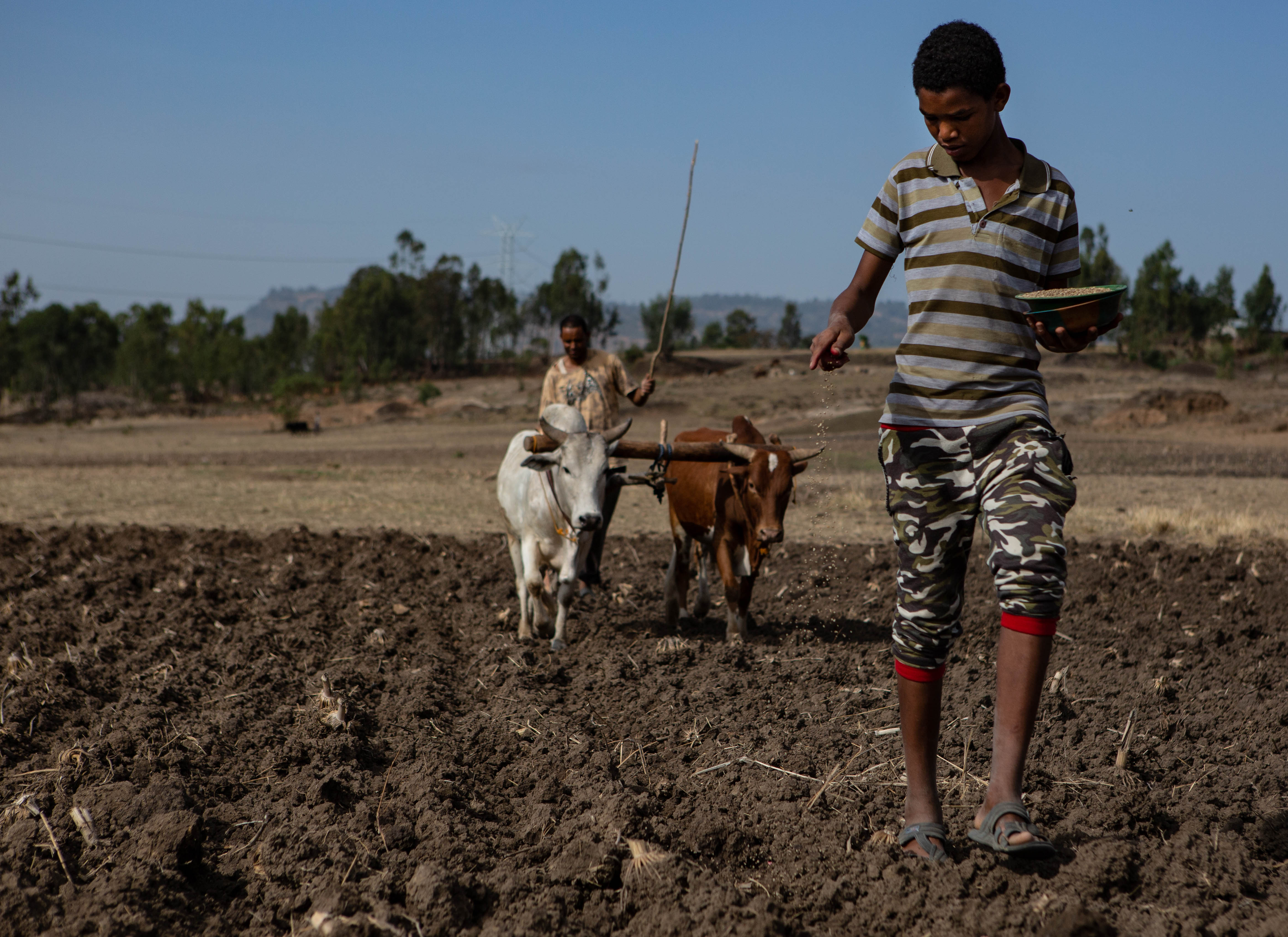
Agriculture makes up more than 40% of Ethiopia’s gross domestic product and is the primary source of employment in the country. Nearly all of Ethiopia’s agricultural production happens on smallholder farms (less than three hectares in size) and nearly all of it is rainfed. Every growing season, millions of people bet on having a favorable climate for their crops and livelihoods. A drought, or even small variations in weather and climate conditions during the rainy season, not only threatens the food security of specific communities, but also negatively impacts Ethiopia’s economy.
A young Ethiopian man sows the field before the plow. Photographer Jacquelyn Turner, ACToday/IRI.
For this reason, the Ethiopian government was early to recognize the importance of a highly capable national meteorological service to maintain a robust weather network and be able to generate skillful forecasts for the country.
Not too long ago, it used to be that in order to get climate data for a given location in Ethiopia, you’d have to submit a written request… The process would take at least three days. Now it takes three seconds.
Tufa Dinku
With support from IRI’s ENACTS initiative and Data Library, ACToday’s Tufa Dinku worked with the country’s National Meteorological Agency (NMA) since 2010 to completely transform the way in which the agency generates and delivers climate information. Now people can access 40 years of continuous temperature and rainfall data for the whole country at a 4-kilometer resolution.
“Not too long ago, it used to be that in order to get climate data for a given location in Ethiopia, you’d have to submit a written request to the NMA,” said Dinku, who leads ACToday’s work in Ethiopia. “The process would take at least three days. Now it takes three seconds.”
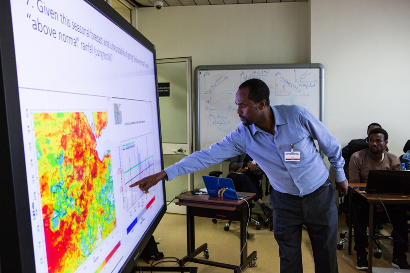
Tufa Dinku, the country lead for ACToday in Ethiopia, discusses the maprooms with a team from the National Meteorological Agency. Photographer Jacquelyn Turner, ACToday/IRI.
While Dinku recognizes the importance of this achievement, he said it only addressed half of the problem. “We generated this great new climate knowledge for the country. Now it needed to permeate into other parts of the government—ones that are responsible for food policy and decision making.”
Under ACToday, Dinku and the NMA built online mapping and data visualization tools custom-made for staff working in the ministries of agriculture and public health and the country’s disaster management agency. Then they held intensive two-week training courses for these non-climate professionals to learn how to use the new tools.
Tufa Dinku, the country lead for Ethiopia, tells his story and describes the efforts of ACToday and the challenges Ethiopia faces in adapting to climate change.
ACToday’s training approach addressed two challenges. The first is that the NMA is a national institution based in the capital, Addis Ababa, but it’s the local level staff in the agriculture sector that need these tools the most. They’re working the closest with farmers. And that’s who NMA invited to take part in the first training.
The other challenge was about scale. No matter how big the NMA is, there’s a limit to how many people it could train to use its services. ACToday’s ultimate goal is to ensure that Ethiopia’s 12 million farming households stand to benefit from better climate information for food security.
“Not only did we train the agriculture staff how to understand and use forecasts, historical climate information and real-time monitoring for their decisions, we trained them to become trainers,” Dinku said.
A participant shares the result of his small group’s work on an exercise during a training held at the National Meteorological Agency in Addis Ababa in October of 2018. Photographer Elisabeth Gawthrop, ACToday/IRI.
Eneye Assefa, a crop expert at the Amhara regional agriculture office, was one of the first participants. She had no meteorological knowledge before the training but now has more confidence to advise farmers on what crops will be more productive to plant based on rainfall forecasts.
In the months since the training, Assefa has worked to pass the knowledge she gained to her colleagues in Amhara, as well as those in administrative units below hers. This is exactly what Dinku hoped would happen—that the participants go back to their respective regions and propagate the training and use of maprooms to others.
Sixty people just like Assefa took part in the first round of trainings. After seeing the effectiveness and popularity of the course, the Ministry of Agriculturehas promised to support many more. By the end of 2020, Dinku hopes at least 5,000 additional agronomists and agriculture extension agents will be trained to use the new tools and to pass that knowledge on to more of their peers.
Eneye Assefa, third seated from the left, speaks during the closing ceremony of the training. Photographer Elisabeth Gawthrop, ACToday/IRI.
“There are 60,000 extension workers in Ethiopia – these are the people who advise and support farmers directly, and who farmers trust. I believe ACToday can reach every one of them,” Dinku said.
Farming Communities in Guatemala Get Unprecedented Access to Climate Services
Sustainable Development Goal 2 is to end hunger and malnutrition and double the agricultural productivity of smallholder farmers by 2030–an ambitious set of targets made more so because of climate variability and change. National governments are working hard to enact and manage policies to help them meet SDG2. However, the success of these policies largely depends on how effectively they can reach millions of smallholder farmers who are trying to grow crops without irrigation. Their livelihoods depend on having a favorable climate during their growing seasons. Droughts and extreme weather events can often spell disaster for these communities, who generally don’t have access to reliable forecasts, warnings and other advisories to help them plan for and avoid the worst outcomes.
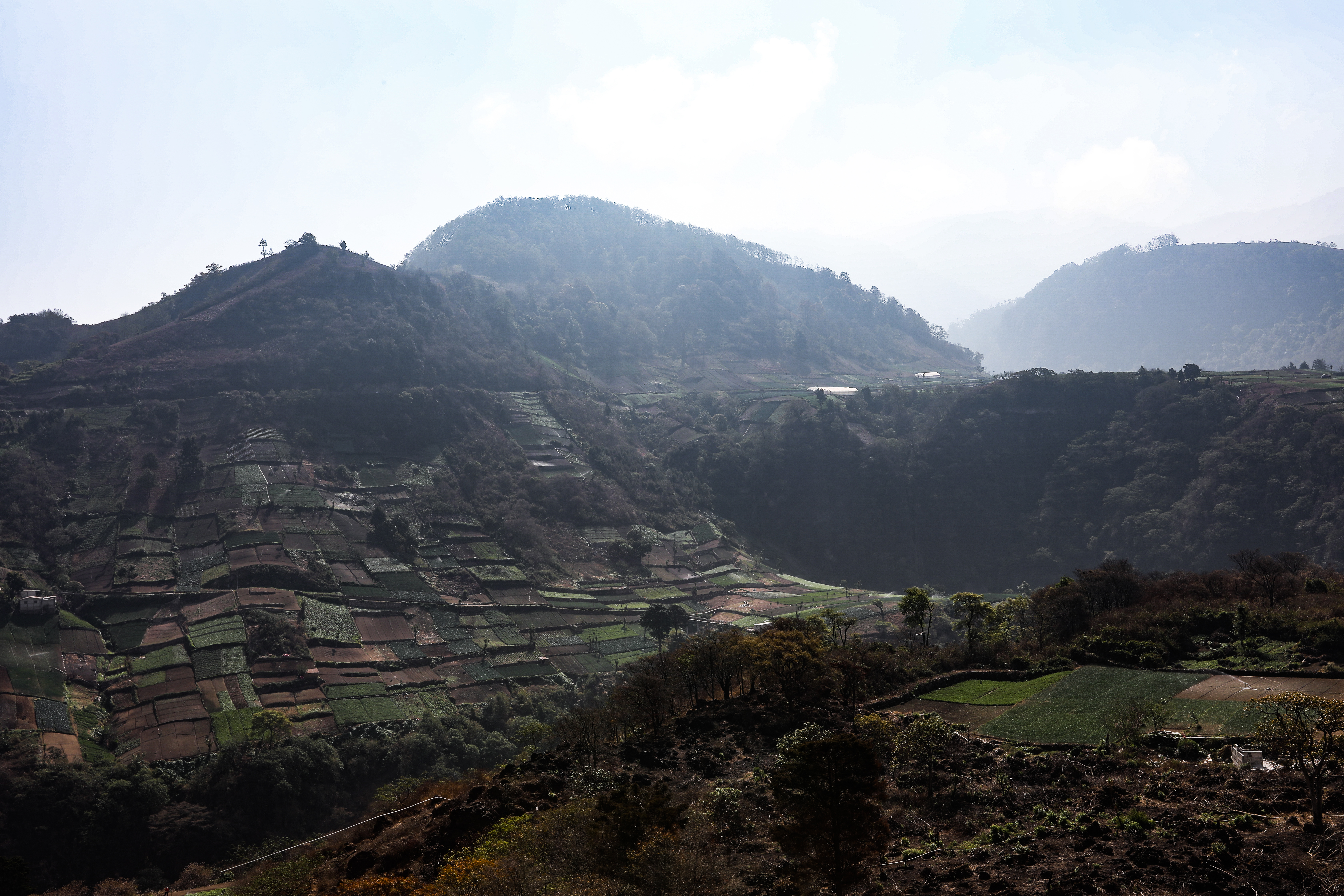
Farms in the highlands near Quetzaltenango, Guatemala. Photographer Elisabeth Gawthrop, ACToday/IRI.
For this reason, ACToday has been working closely with national climate institutions in each of its six countries not only to improve the quality of their forecasts and advisories, but also to ensure that as many people as possible have access to these new products.
One of our biggest successes has been in Guatemala, where chronic malnutrition rates are the fourth-highest in the world and the highest in Latin America and the Caribbean, and where the poorest communities have recently faced multi-year droughts.
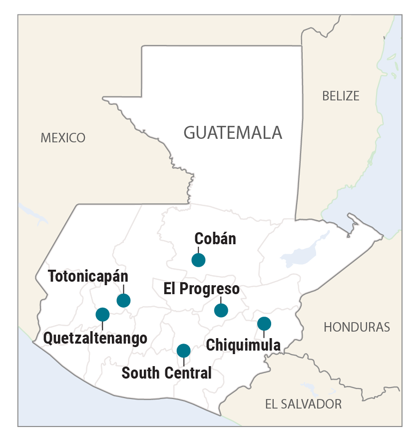
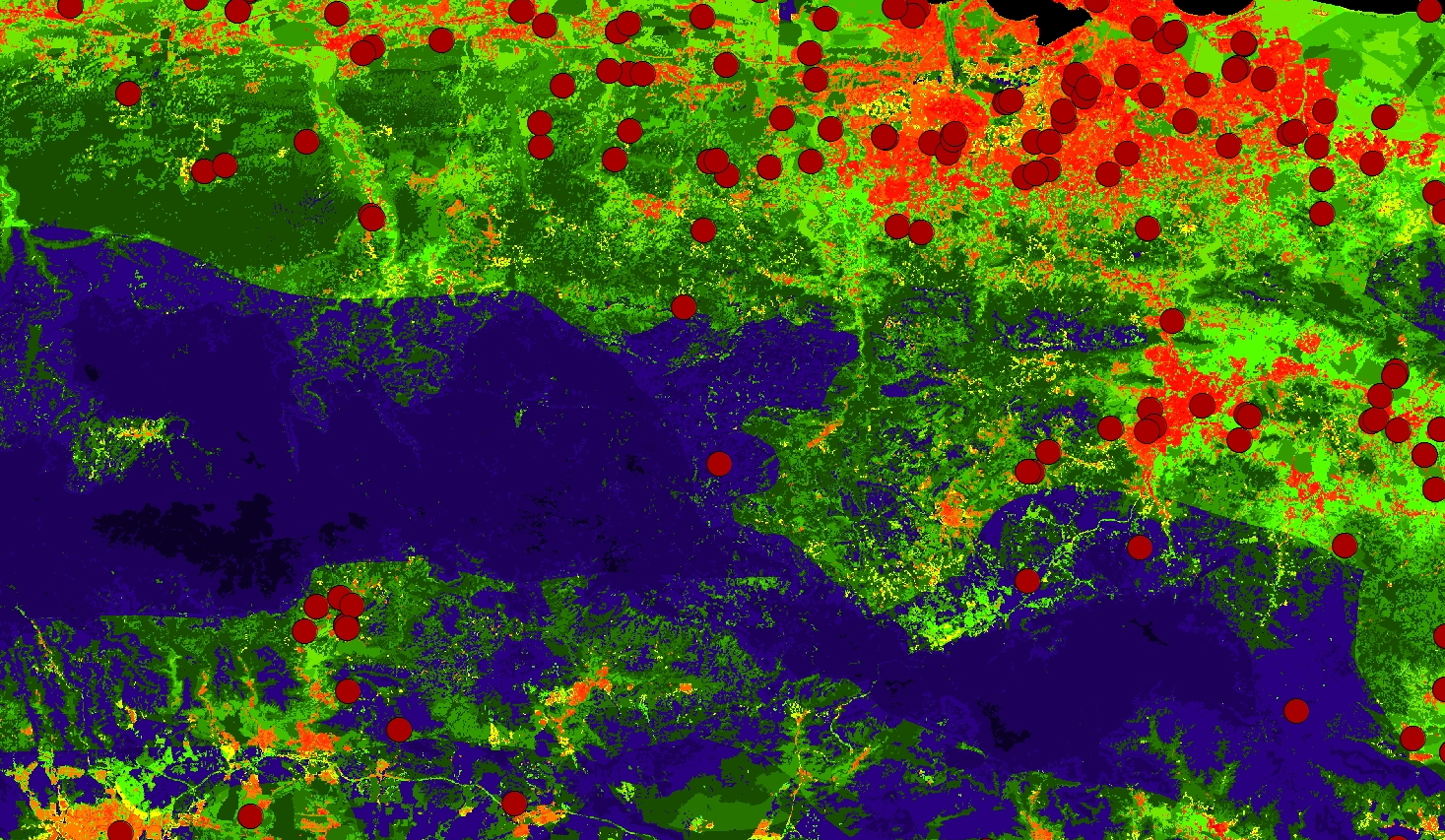
In the spring of 2019, ACToday helped launch five new information-sharing roundtables across the country designed to give farmers unprecedented access to state-of-the-art climate information, products and tools that they need to increase crop productivity and improve food security (see map).
The roundtables, or mesas técnicas agroclimáticas (MTAs), build on an existing model in Guatemala by the CGIAR Research Program on Climate, Agriculture and Food Security (CCAFS), an ACToday partner.
Through these roundtables, ACToday is able to work with community leaders to bring together farmers and other stakeholders to regularly review recent climate conditions, share the latest forecasts, and recommend actions for communities to take. It’s a mechanism that gives thousands of marginalized growers across Guatemala a venue in which to voice their needs and concerns, directly or through representatives and intermediaries.
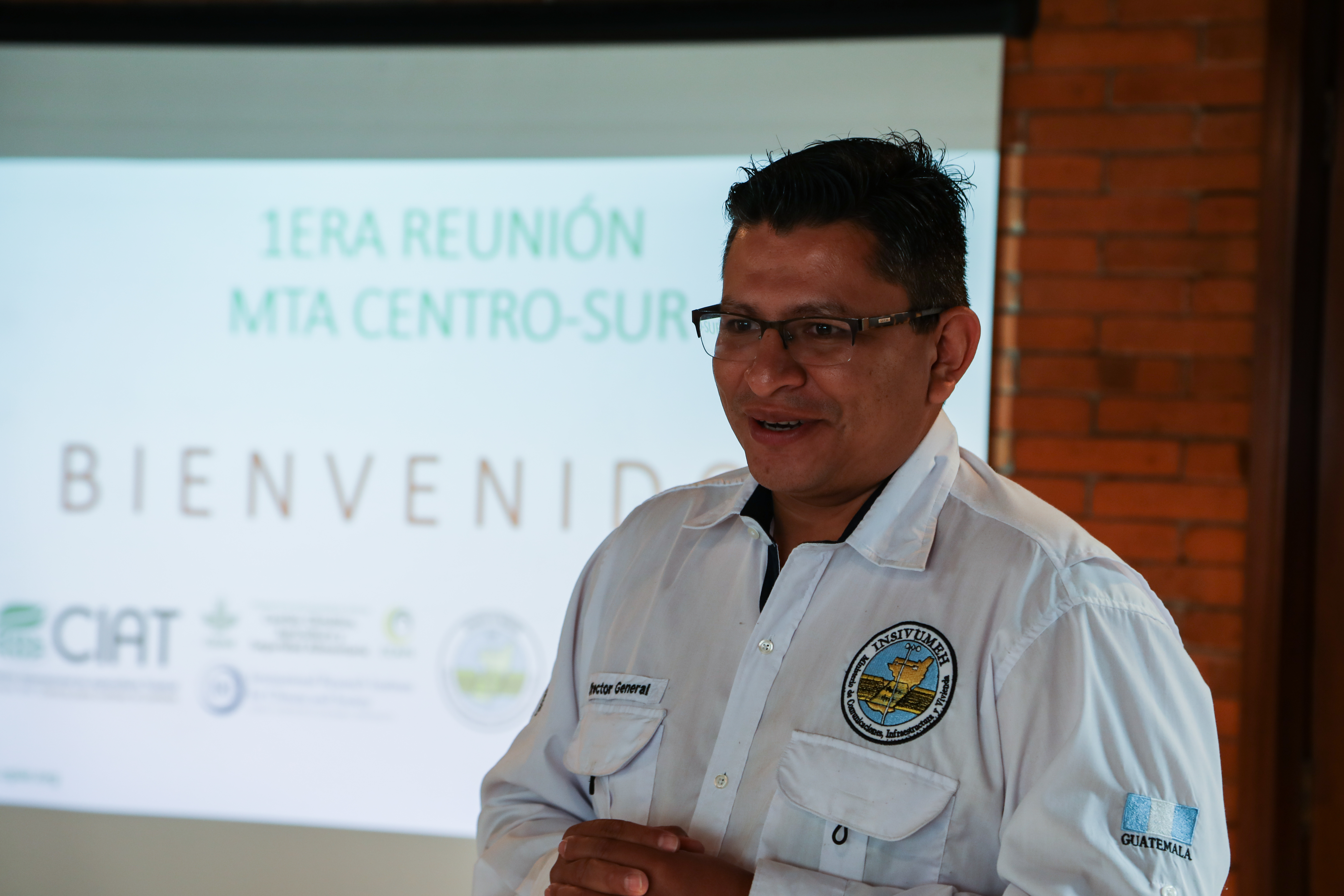
“Now farmers can communicate directly with their government, and their government can learn directly from farmers about the challenges they face, and what tools might help them solve those challenges”, said Juan Pablo Oliva, director of INSIVUMEH, Guatemala’s national meteorological agency, and ACToday partner.
For example, the roundtables in the regions of Totonicapán and Quetzaltenango focus on reaching indigenous communities, who, due to barriers of language and geography, often face particularly high hurdles in accessing relevant climate information. “We want our forecasts to make it to these farmers, in their local languages, so they can incorporate the information into their agricultural calendars,” said ACToday’s Diego Pons, who is from Guatemala. “Historically, they’ve been left out of the loop.”
We want our forecasts to make it to these farmers, in their local languages, so they can incorporate the information into their agricultural calendars. Historically, they’ve been left out of the loop.
Diego Pons
The roundtables are a way of correcting this. By tapping into the best climate information available to help decide what to plant and when to plant it, these communities can take more control over their own livelihoods.
“Our hope is that we’ll see incomes rise, more kids staying in school, and more Guatemalans staying on their land,” Pons said.
Another roundtable, in the south-central region, addresses the needs of Guatemala’s coffee producers. Coffee is one of the most important cash crops in the country, and 96% of it is grown by small producers who have less than three hectares of land, said Mariela Meléndez of Anacafé, the country’s national coffee association.
“Many smallholder coffee producers will also grow corn or beans next to their coffee plantations to provide food for their families. Income from coffee helps these families give their children access to education, improve their quality of life and climb out of extreme poverty,” she said.
MTAs are a crucial part of creating sustainable feedback loops between stakeholders and users of climate information.
“The roundtables constitute an excellent example of farmers, government agencies and international organizations working together to effectively embed the best possible climate knowledge into actual decisions,” said ACToday co-director, Walter Baethgen. “This is an example of the “culture” that ACToday is trying to build in the routine work of governments and development agencies.”
A New Climate Academy in Bangladesh
While one ACToday team was working to organize information-sharing roundtables for Guatemala’s farming communities, another team was busy 10,000 miles away, developing an altogether different model to connect climate information providers and decision makers.
The Bangladesh Academy for Climate Services (BACS), launched in summer 2018, was the first of its kind in the country. Based at the Independent University, Bangladesh (IUB), the new academy offers climate trainings and resources to professionals working in agriculture, food policy, disaster preparedness, public health and other fields. It also provides a platform to connect producers and users of climate information and improve coordination of efforts in the climate services space.
ACToday/IRI hosted a training in New York with support from Climate Services for Resilient Development and the International Maize and Wheat Improvement Center in March of 2018.
Bangladesh may be one of the most vulnerable countries to climate change, but it is also where almost everyone—all the way to the smallest communities—is aware of climate thanks to massive awareness-raising campaigns and adaptation initiatives.
Saleemul Huq, ICCCAD
“Bangladesh may be one of the most vulnerable countries to climate change, but it is also where almost everyone–all the way to the smallest communities–is aware of climate thanks to massive awareness-raising campaigns and adaptation initiatives,” said Saleemul Huq, director of the International Center for Climate Change and Development (ICCCAD). However, climate thinking still needs to be better integrated into all sectors of Bangladesh’s economy, Huq said, which is why ICCCAD was eager to partner with ACToday, the International Maize and Wheat Improvement Center (CIMMYT) and the Bangladesh Meteorological Department (BMD) to launch BACS.
“There is a gap in understanding and communication between climate scientists, policy planners, development and extension organizations, and downstream users of climate information,” said Ziaul Islam, from Bangladesh’s Ministry of Planning, who took the very first BACS course.
Addressing this gap, and improving climate services overall in Bangladesh will help improve the scale and efficiency of adaptation projects, particularly with respect to agriculture, food security and nutrition. Nearly a quarter of Bangladeshis–40 million people–are food insecure, and 11 million suffer from acute hunger.
Participants listen to a presentation during a training held at the Bangladesh Meteorological Department in Dhaka in October of 2019. Photographer Jacquelyn Turner, ACToday/IRI.
By the end of 2019, BACS will have trained approximately 40 professionals, with additional courses planned for 2020. The trainings enable decision makers like Islam to get a deeper understanding about how climate can impact their sectors and their projects, and how to take advantage of data tools, forecasts and other products developed by national agencies.
Climate Risk Insurance for Colombia’s Smallholder Rice Farmers
The work we’ve shared in the previous sections highlight ways that ACToday has helped create advanced and sustainable climate services tailored for agricultural decision making. Countries are using these new services to manage many of the climate-related risks to their food systems. However, even the best climate services by themselves cannot manage the entire range of climate risks that farmers confront. Farmers in the United States and other developed countries are able to cover some of the remaining risks through traditional insurance. If their crops are destroyed by a drought or a storm, they can file a damage claim with the insurance company, which would then send out an assessor to verify and quantify the damages. However, in the six ACToday countries—and most other developing countries—such a system becomes prohibitively expensive for companies, and ultimately makes premiums unaffordable to the rural smallholder farmers who most need insurance.
To address this challenge, IRI has been one of the pioneers to develop a new type of insurance called index insurance. Index insurance payouts are based on an index of weather, such as rainfall measured by satellites or at a local weather station. If the amount of rainfall during critical stages of a crop’s growth cycle doesn’t reach a pre-specified threshold, farmers automatically get compensated without having to file any claims. This innovation has significantly lowered the transaction costs and risks for insurance companies, enabling them to keep premiums low and enabling millions of farmers access to coverage previously unavailable to them.
Index insurance is a key component of ACToday’s work in all six countries, and teams have been working with government and private sector partners to design products tailored to the needs of each country. One of our earliest and most committed partners has been Fedearroz, the rice producers’ federation of Colombia.
Fedearroz represents the country’s 28,000 rice farmers, which together harvest more than 2.5 million tons of the crop each year. Rice is one of the key basic staple foods in Colombia. On average, Colombians consume more than 66 lbs (30 kg) of rice per person per year.
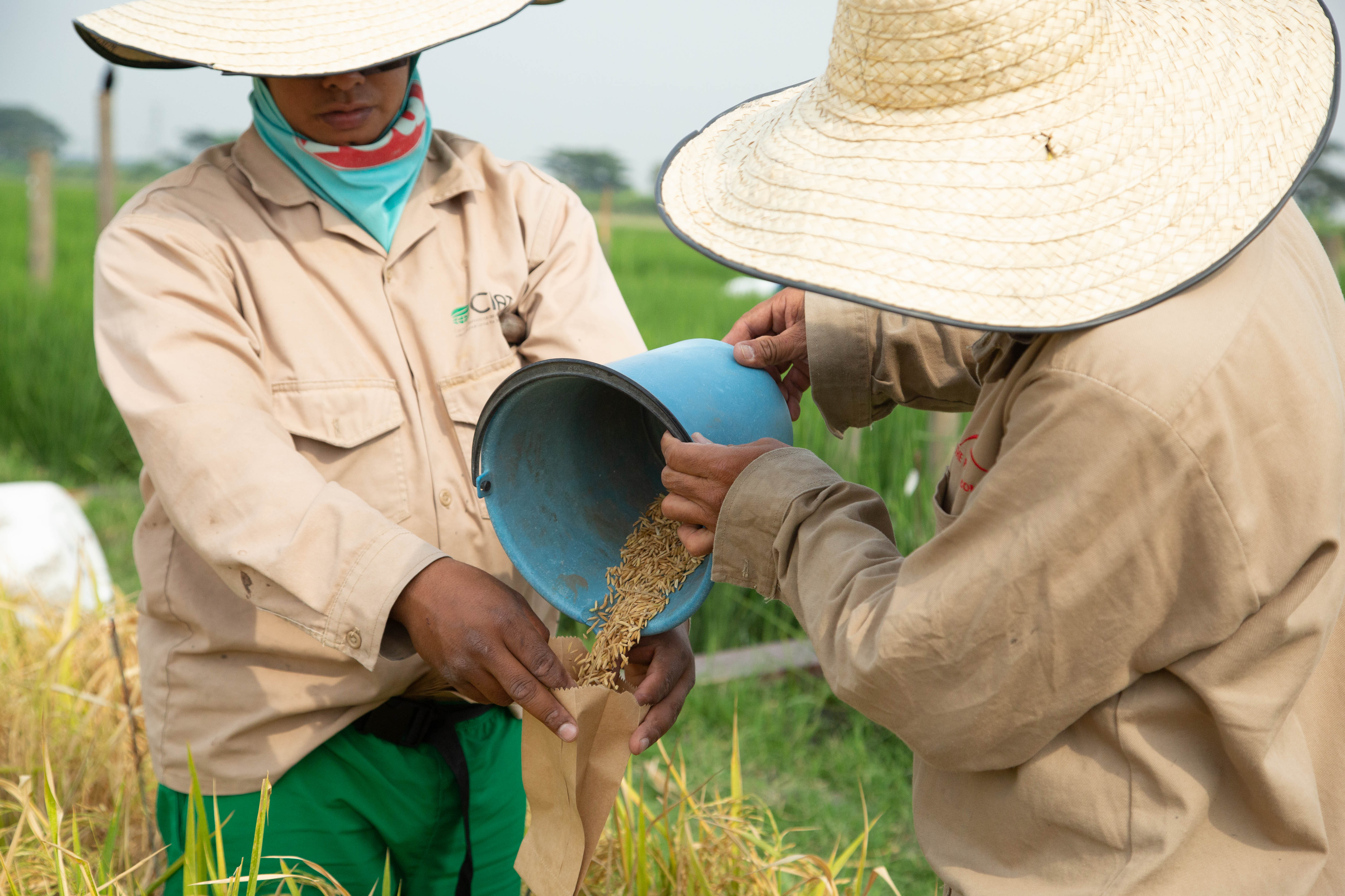
Two field laborers pour harvested rice grains into a specially labeled packet for seed collection and storage at CIAT in Cali, Colombia. Photographer Jacquelyn Turner, ACToday/IRI.
“The support of ACToday to our index-based insurance pilot is crucial to our plans to implement climate-smart rice production in Colombia, contributing to increased food security in our country,” said Patricia Guzman, the deputy director of technology at Fedearroz.
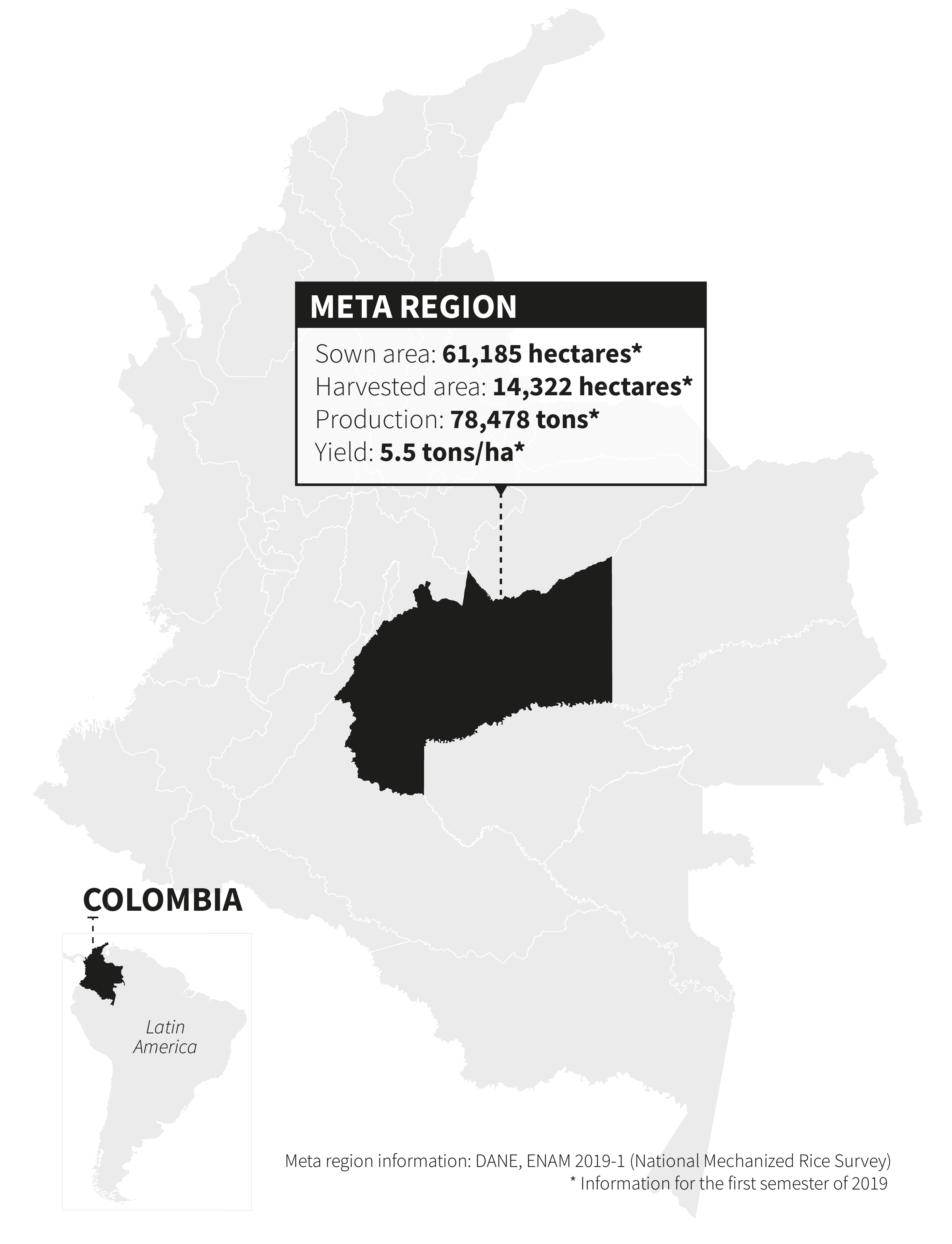
With ACToday technical and training support, Fedearroz will launch a pilot insurance project in March of 2020 for 100 farmers in the Meta region, which produces a sixth of all the rice in Colombia.
“Rice is an extremely important crop for Colombia’s food security, and farmers face constant climate risks, from drought to excessive rainfall, that can damage or destroy crops and reduce income,” said ACToday’s Manuel Brahm, part of the project’s Colombia team.
Brahm and others on the team have been training and supporting Fedearroz staff to design index insurance products that will protect their farmers against climate-related crop losses. ACToday and Fedearroz have held multiple workshops with rice farmers there to understand local perspectives and needs.
“They’ve helped us understand which stages of the rice growing cycle they feel are most vulnerable to damage from too much or too little rainfall, which allows us to define a coverage window for the insurance product,” Brahm said. “We also asked them to rank years from best to worst in terms of yields, and we can compare this in real time to what the climate data says using IRI’s Data Library.”
This information feeds into the design of the insurance and helps ensure that companies will be able to provide an affordable product that covers as much risk as possible for the greatest number of farmers.
ACToday is catalyzing a very favorable institutional landscape in Colombia, promoting the development of complementary capacities in different productive sectors, so we can take full advantage of the opportunities that climate offers to us.
Patricia Guzman, Fedearroz
“Our experience shows that a top-down approach—where scientists or government agencies decide what insurance communities need—doesn’t work in the long term and doesn’t scale up as quickly,” said economist Daniel Osgood, who leads IRI’s Financial Instruments Sector Team. “ACToday is designing index insurance through a participatory process that has involved farmers from the very beginning—they’re the ones who will be deciding whether or not to buy coverage.”
ACToday’s approach has been to train and support the Fedearroz staff to develop the index insurance in-house. This leaves the association with the technical capacity and experience to scale up to more farmers over time. It can also serve as a model for other associations, such as coffee growers, to build on.
Produced by the IRI Communications Team
For more information about ACToday, please visit iri.columbia.edu/actoday. To support work like this, please email ACToday[at]iri.columbia.edu.
Columbia World Projects’ first project, ACToday, aims to combat hunger and improve food security by increasing climate knowledge in six countries that are particularly dependent on agriculture and vulnerable to the effects of climate change and fluctuations — Ethiopia, Senegal, Bangladesh, Vietnam, Colombia, and Guatemala. This article takes an in-depth look at recent activities in Vietnam that advance ACToday’s objective of helping the country meet its goals on food security.
When many people envision food security in Vietnam, they think of rice. More than seven million tons of it are harvested each year, making Vietnam the third largest exporter of the crop. What isn’t exported feeds the Vietnamese population: rice provides 65% of people’s daily calories on average, making it a vital piece of both food and financial security.
However, many of those working in agriculture in Vietnam believe rice may not be the future of food security for the country going forward. Cash crops such as coffee, cashews and fruit may provide more stability and better value, allowing small-scale farmers to start to pull themselves out of poverty and to access higher nutrition foods. Regardless of the crop, the uncertainties of a variable climate pose a challenge to farmers’ success.
Bristol Powell and Audrey Vadillo of IRI examine details of a sustainable development plan with staff from the General Statistics Office and Agriculture for Nutrition and Health (A4NH). Photo by Jacquelyn Turner/IRI.
“We were interested in having the decision makers be in the same room. We wanted them to help us to identify the gaps and overlaps between the information decision makers need and the ability of climate agencies to provide it. ”
Dannie Dinh, country manager for ACToday in Vietnam
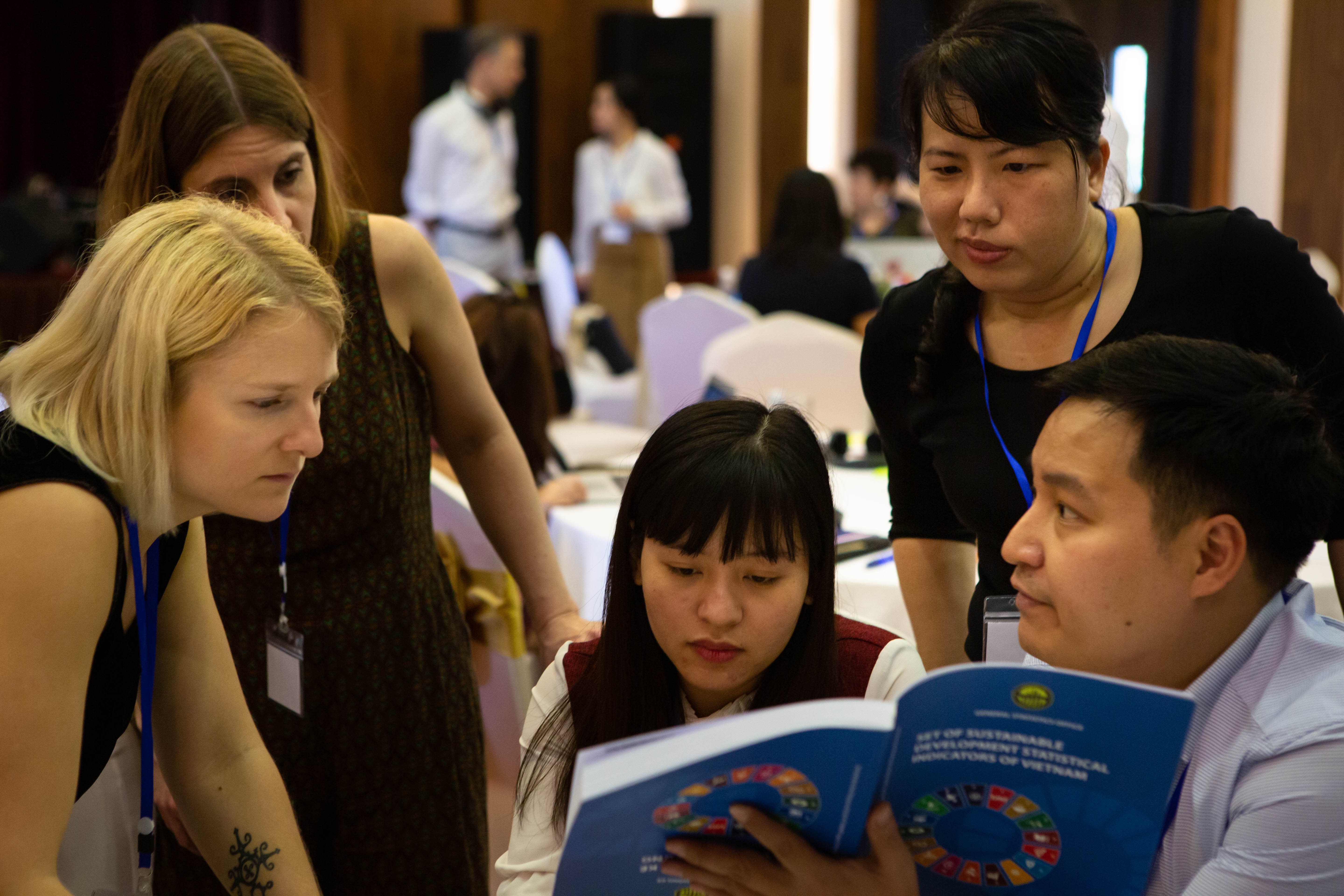
These are the kinds of ideas that teams from the International Research Institute for Climate and Society (IRI) and the Center for International Tropical Agriculture (CIAT) heard at a policy workshop in March in Vietnam, as part of Adapting Agriculture to Climate Today, for Tomorrow (ACToday), the first Columbia World Project. The workshop, supported by ACToday and by a CIAT-implemented project known as DeRISK, convened representatives from government agencies and farmers’ groups to discuss what climate information is currently being generated and used for agriculture and where the process can be improved for more effective decision making.
The IRI and CIAT organizers asked officials from the National Center for Hydrological and Meteorological Forecasting (NCHMF), the Vietnam Institute of Meteorology, Hydrology and Climate Change (IMHEN), and the Ministry of Agriculture and the National Institute of Nutrition to work together on their approaches to food security and nutrition. Each of the agencies presented their mission and objectives and explained their role in helping Vietnam achieve UN Sustainable Development Goal 2: ending hunger and malnutrition, achieving food security, and promoting sustainable agriculture.
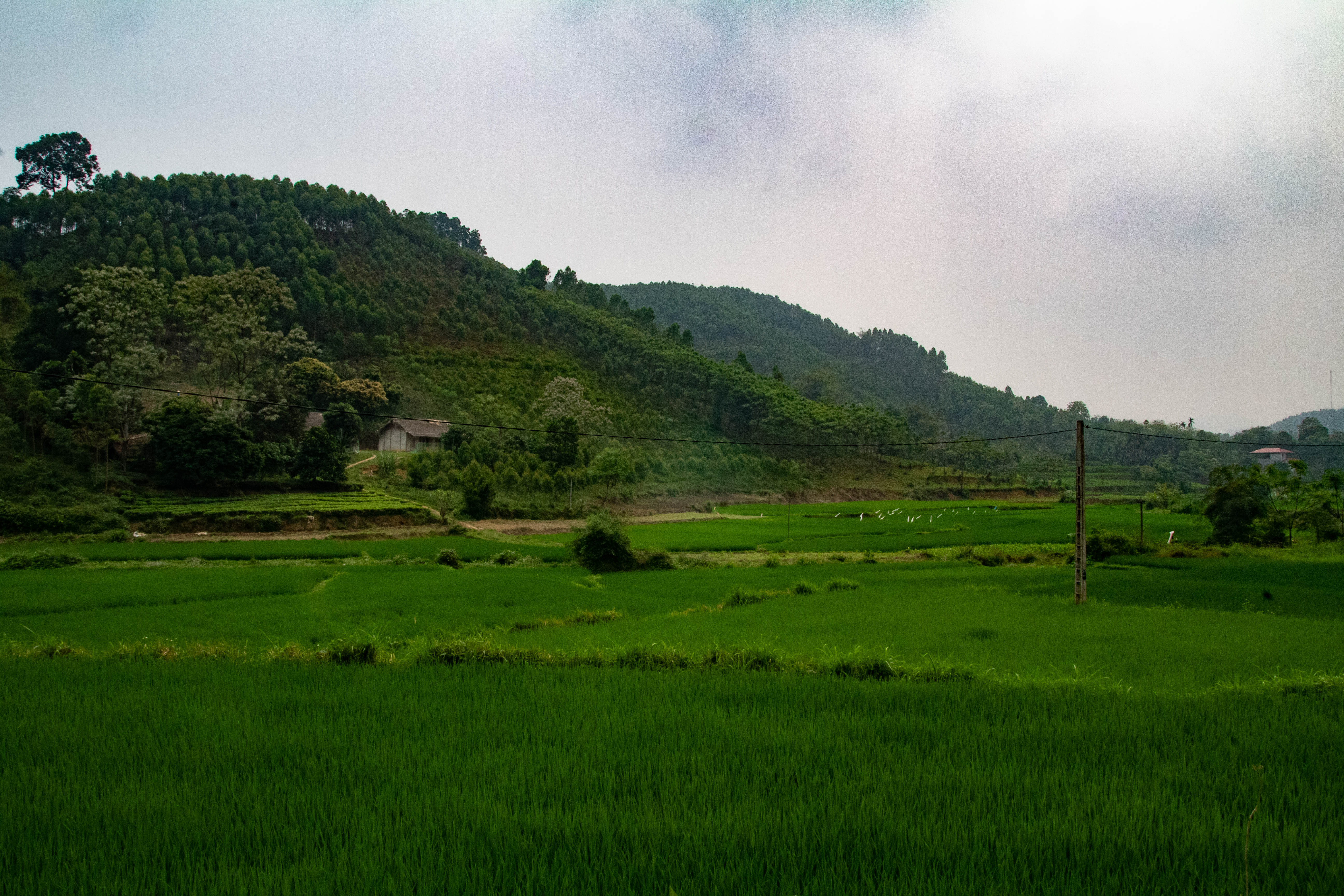
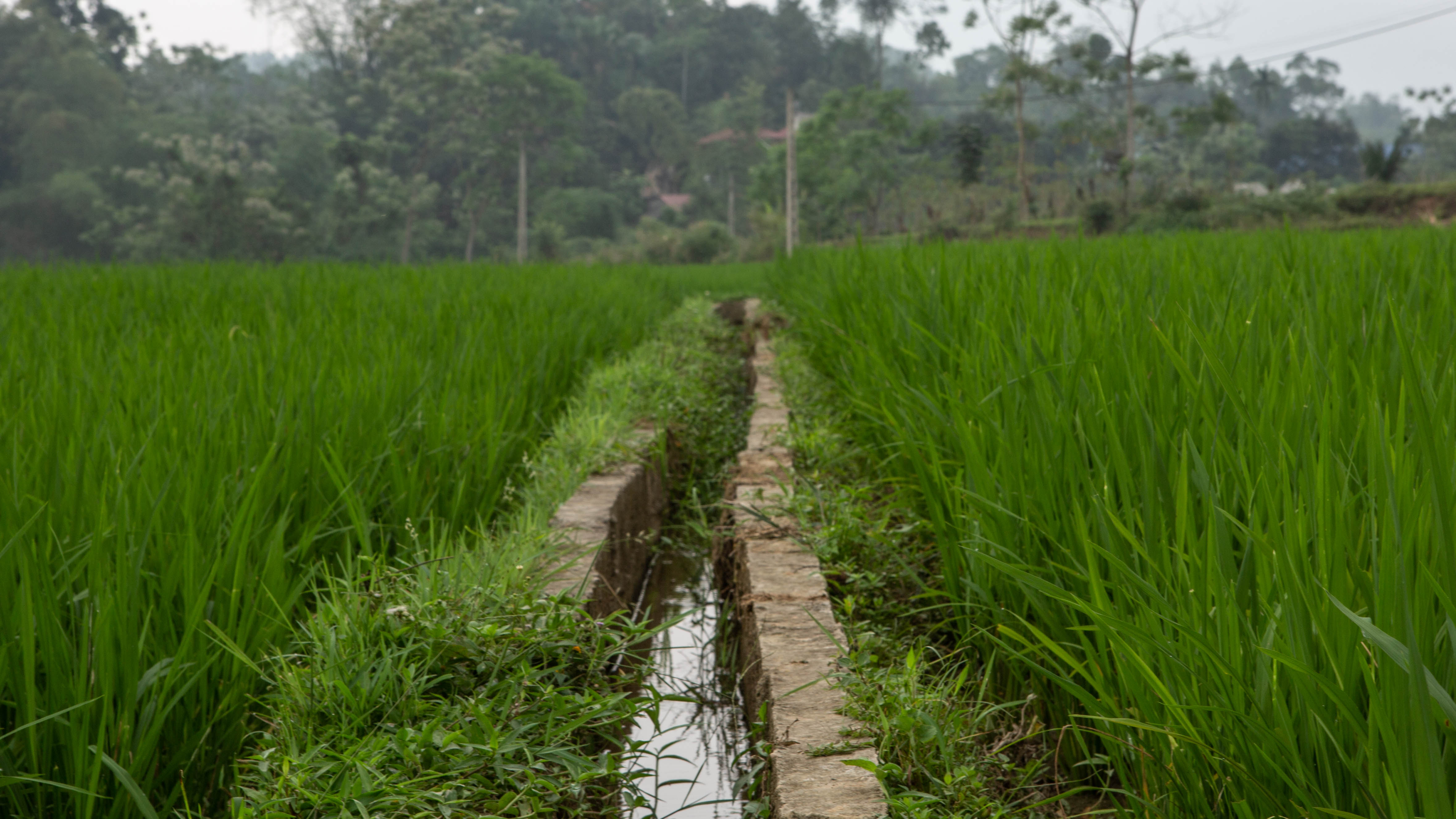
An irrigation channel runs through a rice paddy in the Yên Bái Province. Photo by Jacquelyn Turner/IRI.
“We were interested in having the decision makers be in the same room,” says Dannie Dinh, who co-leads activities for ACToday in Vietnam. “We wanted them to help us to identify the gaps and overlaps between the information decision makers need and the ability of climate agencies to provide it. ”
It worked. During one exchange, an official from the agriculture ministry stood up to suggest that a sub-seasonal climate forecast (information about what will happen two weeks to 2 months into the future), made specifically for a particular crop, would be very useful for farmers. Immediately, a representative from the country’s forecasting center responded that such a forecast did exist and was already available online. Interactions like these are critical, says Dinh, because they help illustrate an important problem IRI has addressed for decades across the world: sometimes the climate information produced by one part of government is unknown or not very useful to its intended audience in another part of government. Carefully organized face-to-face meetings of stakeholders can be an effective approach to share ideas and identify communication and collaboration challenges.
ACToday country lead in Vietnam, John Furlow, presents at the policy workshop. Photo by Jacquelyn Turner/IRI.
One of the primary ways in which the ACToday project is helping governmental organizations achieve their SDG targets is through the development and improvement of climate services. Climate services start with the production of relevant climate information, as well as the translation of that information for use by decision makers. These services help farmers, policy makers and other agriculture and nutrition stakeholders manage climate variability and change. Climate services can include, for example, forecasts that provide estimates of temperature and rainfall for upcoming growing seasons. These estimates can help inform farmers’ decisions about which crops or crop varieties might do well under projected conditions. For smallholder farmers, such advice can mean improved yields and a lowered risk of food insecurity. A climate services product that is not tailored to the needs of farmers is unlikely to be used.
Some workshop attendants were already thinking ahead, hoping that new climate services products might also assist in planning for the introduction of new cash crops.
Dr. Truong Mai from the National Institute of Nutrition writes notes for a group activity where participants identified challenges to achieving their objectives for UN Sustainable Development Goal 2.
One official, Do Minh Phuong from the National Institute for Agricultural Planning and Policy (NIAPP), has been using a global scale drought prediction tool developed by IRI to support coffee production, but he found that the resolution was not high enough in Vietnam. His team is interested in expanding the growing of coffee within the country’s central highlands, an area known for extreme poverty and tricky climate variability. Enhanced forecasting tools could help implement coffee production in the region and pull a significant portion of the population out of poverty. ACToday is now working with the NCHMF to develop a higher resolution drought forecast specific to Vietnam.
“We were able to learn directly from the people responsible for these ambitious policies how climate variability is impeding Vietnam’s progress toward food security and better nutrition, ” says John Furlow, the country lead for ACToday in Vietnam. “We’re building working relationships between the users of climate information and those agencies responsible for providing that information, and evaluating where ACToday can best provide support to Vietnam. ”
ACToday country lead John Furlow describes the current work going on in Vietnam under the ACToday project.
Adapting Agriculture to Climate Today, for Tomorrow (ACToday) is a Columbia World Project led by the International Research Institute for Climate and Society. The project aims to combat hunger and improve food security by increasing climate knowledge in six countries that are particularly dependent on agriculture and vulnerable to the effects of climate change and fluctuations: Bangladesh, Colombia, Ethiopia, Senegal, Vietnam and Guatemala. This article takes an in-depth look at a new series of roundtables launched in Guatemala to advance ACToday’s goals.
By Elisabeth Gawthrop
Thousands of Guatemalan farmers will now have access to state-of-the-art forecasts and other climate information to help them increase crop yields and earn more, thanks to five new regional collaborative networks launched by Columbia University’s International Research Institute for Climate and Society and its international and Guatemalan partners.
Key Partners
International Research Institute for Climate and Society (IRI)
CGIAR Research Program on Climate Climate, Agriculture and Food Security (CCAFS)
International Center for Tropical Agriculture (CIAT)
National Institute for Seismology, Volcanology, Meteorology and Hydrology (INSIVUMEH)
The collaborations are called mesas técnicas agroclimáticas, or agroclimatic roundtables, abbreviated as MTAs. They comprise experts and decision makers ranging from small farmers to representatives from a wide variety of institutions, including local municipalities, national government, humanitarian agencies, farmers associations and international organizations. The representatives meet regularly to discuss recent climate conditions and the latest forecasts. They then agree on a set of good agricultural practices for the region, as well as strategies to communicate those recommendations.
MTAs are a key component of IRI’s work in both Guatemala and Colombia for Adapting Agriculture to Climate Today, for Tomorrow (ACToday), the Columbia World Project it leads. The goal of ACToday is to use climate science and services, including state-of-the-art forecasting tools, to help Guatemala and five other countries combat hunger and improve food security.
“It’s important we don’t underestimate the tangible difference these roundtables will make in people’s lives,” said IRI’s Walter Baethgen, who co-leads the ACToday project. “We are ensuring that the best climate information Guatemala produces is not only directly making its way to underserved communities, but that the communities have a say in what information gets produced, based on the needs of their growers.”
Locations of Guatemala’s MTAs as of June 2019. Graphic: Francesco Fiondella/IRI.
The five new MTAs are located throughout Guatemala: from the highlands in the west, to the lowlands in the south, to middle elevations in the northern and eastern parts of the country (see map). They build off an existing MTA launched in Chiquimula as part of AgroClimas, a CIAT/CCAFS project that continues to co-develop the MTAs with ACToday and the other partners. Taken together, these new networks will ensure that tens of thousands of farmers not only have access to important climate information and advisories, but have a way to voice their needs and give feedback to Guatemala’s national meteorological service (INSIVUMEH), which produces such information.
Forecasts for Food Systems
Like in many countries that rely on agriculture economically, many Guatemalans struggle to eat enough food. Chronic malnutrition rates are the fourth-highest in the world and the highest in Latin America and the Caribbean. Around one million farmers in the country are subsistence farmers, many living in areas exposed to climate shocks and without access to irrigation. Even for farmers that have irrigation, severe droughts and floods remain real risks.
Climate information can’t prevent droughts and floods from happening, but a better understanding of the past, present and future climate in a farmer’s region can help that farmer make better-informed decisions. A core value of the MTA process is that the development and delivery of the climate services has to be done with the participation of people all along the value chain of climate information, including to the level of the subsistence farmer.
“National agencies spend a lot of time and effort to improve their ability to observe and forecast climate and weather changes,” said IRI’s Diego Pons. “Often, these advances are either not reaching or not being utilized by the most vulnerable communities, because up until now there hasn’t been a process in place to facilitate this.”
Pons, a postdoctoral research scientist who has conducted field work in Guatemala for more than 10 years, is working to change that by leading ACToday’s work on MTAs in Guatemala. He is encouraged by the positive response to the MTAs from local and national institutions, with high level officials attending the launches of the MTAs and active participation at the events.
“We’re excited that we can have a direct impact on the population. This is something that really gets us up and out of bed every morning.”
Juan Pablo Oliva Hernández, Director of Guatemala’s national meteorological service (INSIVUMEH)
While all of the MTAs follow a similar process, each are designed to respond to local needs. In Guatemala, each region grows different food and has a unique climate.
In the highlands, people rely on the food they grow for their own meals, and they earn some money from selling food at local markets. Farm plots are generally small, ranging from 0.5 to 2 hectares. Water is piped from mountaintops in some areas, while other areas rely only on the rainfall that falls locally. Crops include staples such as maize and beans—often grown using a traditional system called milpa—as well as an array of fruits, vegetables and herbs.
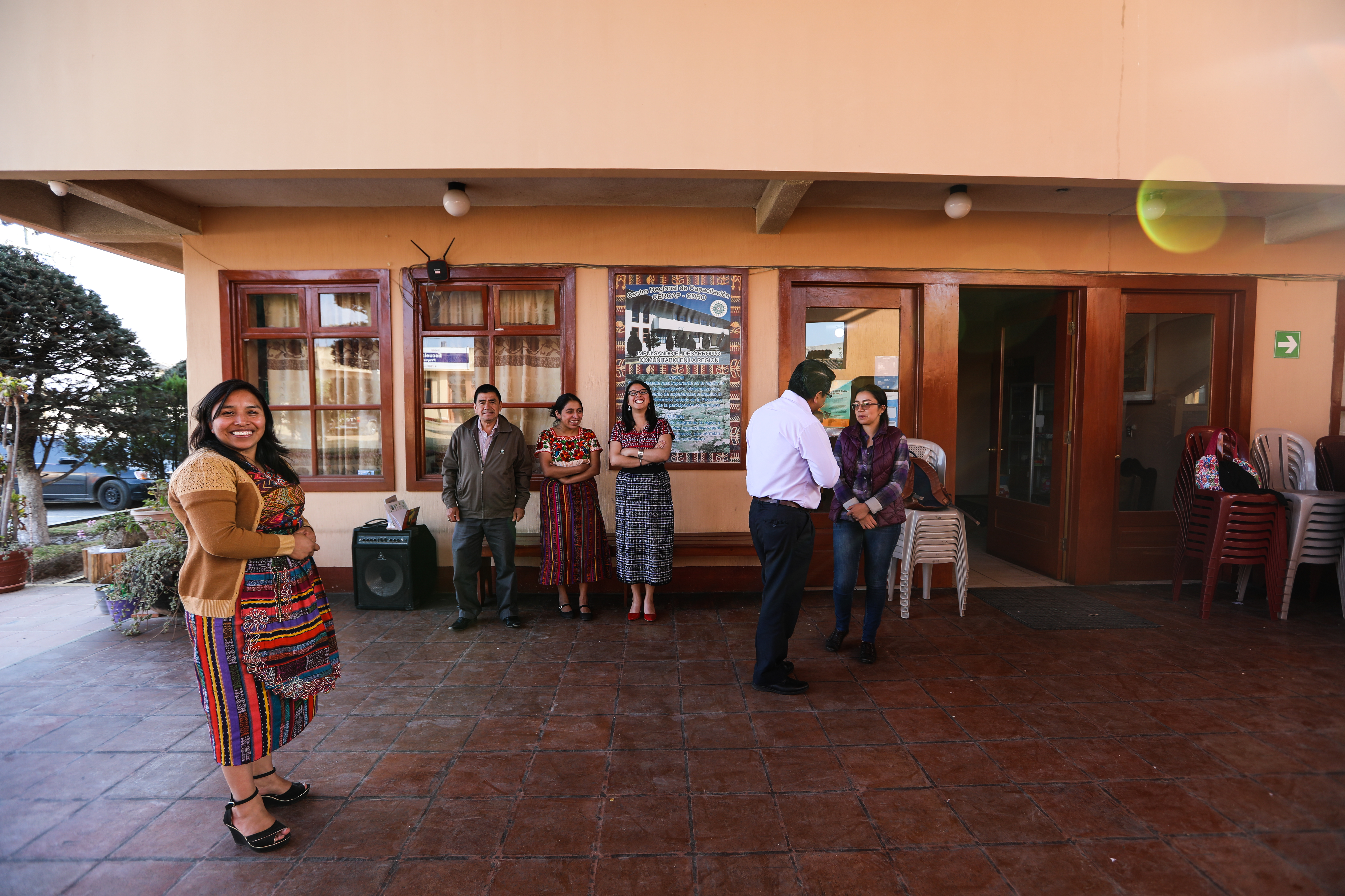
Community structures, networks and ways of communicating also vary throughout the country. For example, the Asociación de Cooperación para el Desarrollo Rural de Occidente, a regional farmers association abbreviated CDRO, has been critical for setting up the new highlands MTAs in Totonicapán and Quetzaltenango.
Leaders of the regional community association of farmers (CDRO) met with representatives from Guatemala’s national meteorological service (INSIVUMEH), IRI and CIAT in March, ahead of the official launches of the Totonicapán and Quetzaltenango MTAs in May. A lot of planning, organizing and relationship-building must happen before an MTA can successfully launch. Photo: Diego Pons/IRI.
“We identified CDRO as a partner because it already has a climate monitoring system and they already have surpassed many of the barriers that kept farmers from getting information. For example, they use local languages and incorporate traditional knowledge in their communications,” said Pons. He and the rest of the ACToday team are learning about the traditional knowledge and indicators that some farmers use for their planning and planting.
“We can now include these traditional perspectives in the forecasts we provide,” said Pons.
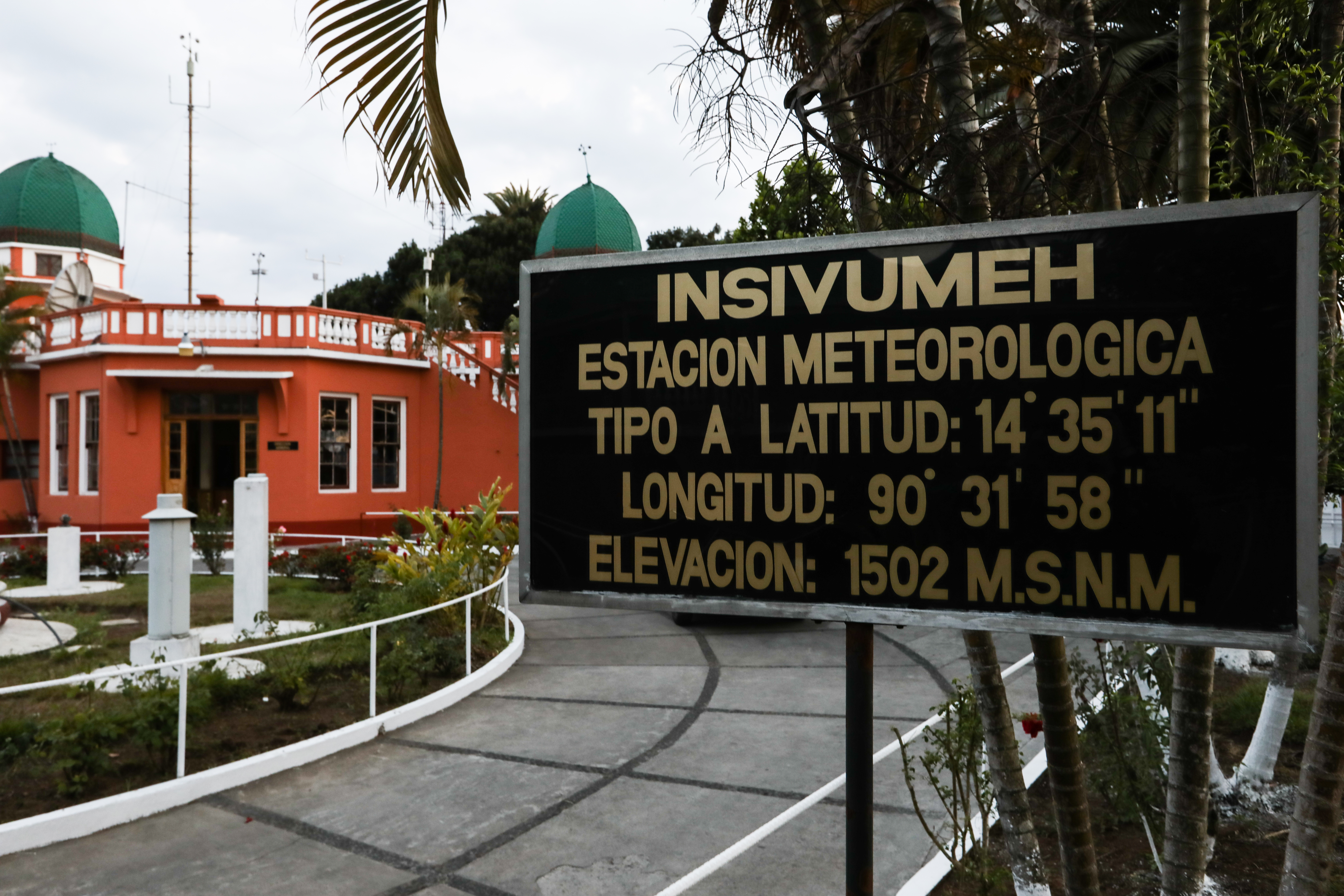
In addition to weather and climate, INSIVUMEH, which is based in Guatemala City, is also responsible for monitoring—and, where possible, predicting—floods, earthquakes and volcanoes.
In Guatemala’s south-central region, the needs and climate challenges of growers are different in a number of ways. Here, much of the land is used to grow coffee and sugar cane, usually on large farms that provide seasonal work and cash for some farmers. Anacafé, the country’s national coffee association, was a natural partner in setting up an MTA in this region.
Mariela Meléndez, who works for Anacafé and coordinates the new south-central MTA, said 96% of Guatemalan coffee is owned by small producers with less than 3 hectares. Coffee cultivation represents the largest agroforestry system in Guatemala, with an area of 305,000 hectares.
“Many small coffee producers will also grow corn or beans next to their coffee plantation, to provide food for their families,” she said. “Coffee, as a cash crop, helps these families provide their children with access to education, improve their quality of life and get out of extreme poverty.”
Communication is Key
Farmers in the south-central region have access to climate information via a coffee smartphone app that already delivers El Niño forecasts from IRI. Any new and improved information ACToday helps generate can easily get conveyed to decision makers through this app.
Go in-depth with the details and science behind the MTA process: read the paper and training manual from our partners at CCAFS and CIAT.
Juan Pablo Oliva Hernández, the director of INSIVUMEH, provides welcoming remarks at the launch of the south-central MTA.
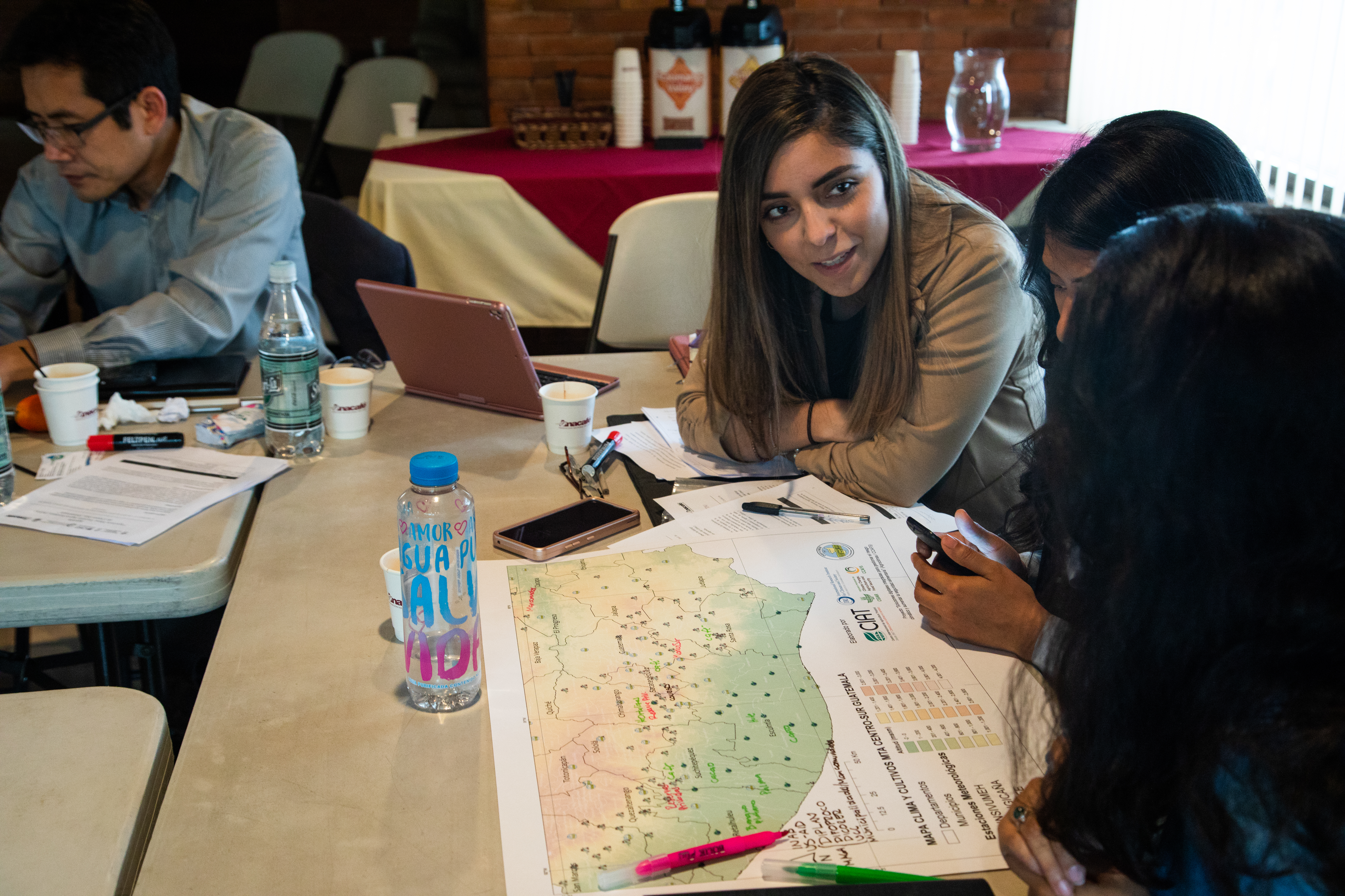
At the launch of the south-central agroclimatic roundtable (MTA), attendees work on an exercise to pool their knowledge about available climate data sources in the region. In addition to the national government’s meteorological stations, some groups have also installed their own. By pooling their data, everyone will overall have a richer and higher quality dataset.
But even with more advanced technology, communicating between people with very different professional and education backgrounds is still difficult.
“The hardest part of climate services is not only generating information that wasn’t there before, but how to get that information to communities in a way they understand and can use on the ground,” said Pons.
The MTA leaders utilize intentional, participatory exercises designed to help facilitate knowledge sharing. These exercises are particularly critical for understanding when climate information could be useful for decisions at the farm level, and the best ways of communicating climate information.
The participative spirit also extends to the managerial level of the MTAs. In a democratic process at the launch of the south-central MTA, each member of the committee wrote down their ideas for a mission and vision statement. Then all were read aloud and discussed before arriving at the agreed-upon, high level statements. The launch also included an exercise to crowd-source the attendees’ knowledge on climate data availability throughout the region.
INSIVUMEH also recognizes the need for improved communication of climate information. “Now that the science has advanced, a process of translation is needed and that is where the MTAs come to serve their purpose,” said Juan Pablo Oliva Hernández, the director of INSIVUMEH. “The MTAs can bring these products to the regions. We’re excited that we can have a direct impact on the population. This is something that really gets us up and out of bed every morning,” said Oliva Hernández.
More on the new MTAs from our partners:
Se inaugura Mesa Técnica Agroclimática (MTA) de Centro-Sur Guatemala, espacio de diálogo entre actores locales, nacionales y regionales para comprender el posible comportamiento del clima y generar recomendaciones para disminuir los riesgos asociados a la variabilidad climática. pic.twitter.com/mKSpP2jzQy
#NoticiasAnacafé | Diferentes actores locales, nacionales y regionales vinculados con servicios climáticos se reunieron en las instalaciones de Anacafé para inaugurar la Mesa Técnica Agroclimática -MTA- para Centro-Sur de Guatemala.
Columbia World Projects’ first project, ACToday, aims to combat hunger and improve food security by increasing climate knowledge in six countries that are particularly dependent on agriculture and vulnerable to the effects of climate change and fluctuations: Bangladesh, Colombia, Ethiopia, Senegal, Vietnam and Guatemala. This article takes an in-depth look at a series of roundtables that ACToday, which is led by Columbia’s International Research Institute for Climate and Society (IRI), has launched in Guatemala to advance ACToday’s goals.
Five new roundtables launched this year by ACToday and local partners will give thousands of Guatemalan farmers access to state-of-the-art forecasts and other climate information to help them increase both their crop yields and earnings.
“The hardest part of climate services is not only generating information that wasn’t there before, but how to get that information to communities in a way they understand and can use on the ground,” said Diego Pons, a postdoctoral research scientist at IRI who has been deeply involved in the implementation of the roundtables.
The roundtables aim to bridge the gap between science and the communities who need it in countries like Guatemala where many struggle to eat enough healthy food. Chronic malnutrition rates in Guatemala are the fourth-highest in the world and the highest in Latin America and the Caribbean.
Roundtables are a key component of ACToday’s work in both Guatemala and Colombia as the project uses state-of-the-art forecasting tools to reduce malnutrition and increase sustainable agriculture.
The roundtables—or mesas técnicas agroclimáticas—are made up of experts and decision makers including farmers and farmers associations, representatives from local and national government agencies, and international organizations such as the UN Food and Agriculture Organization. Participants meet regularly to learn about the kind of information that farmers need, as well as to discuss recent climate conditions, the latest forecasts, recommended actions for farmers and strategies for communicating those recommendations beyond the roundtables themselves.
Together, these roundtables will ensure that tens of thousands of smallholder farmers not only have access to important climate information and advisories, including those produced by ACToday, but also have a way to voice their needs and give feedback to Guatemala’s national meteorological agency, which produces such information. ACToday has supported the agency in improving its forecasts through NextGen, a new set of high-quality, flexible and tailored seasonal forecasts. The roundtables have focused, in particular, on incorporating farmers from indigenous communities, who, due to barriers such as language and geography, often face particularly high hurdles in accessing relevant climate information.
Roundtables are a key component of ACToday’s work in both Guatemala and Colombia. Around one million farmers in Guatemala are subsistence farmers, many living in areas vulnerable to climate shocks and without access to irrigation. Even for farmers that have irrigation, severe droughts and floods remain real risks. The roundtables help these farmers obtain access to timely climate information that’s critical to increasing their crop productivity, which in turn improves food security in areas that are struggling.
Climate information can’t prevent droughts and floods from happening, but a better understanding of the past, present and future climate in a farmer’s region can help that farmer make more informed decisions. That’s why a core tenet of the roundtable process is that the development and delivery of climate services has to be done with the participation of people all along the value chain of climate information, including subsistence farmers.
Each roundtable is designed to respond to local needs in different areas of the country. In the highlands of Guatemala, where many farmers subsist on food they grow themselves, for example, a local farmers association has been closely involved with the roundtables. In south-central Guatemala, by contrast, coffee and sugar cane are grown on large farms, which employ seasonal workers paid in cash. In this region, a roundtable partner is the national coffee association, which represents the country’s coffee farmers and works to improve their ability to grow and sell coffee. Regardless of regional variation, the overall goal of each roundtable is the same: to make sure that farmers have the highest quality climate information that’s relevant to their growing decisions.
The roundtables build off of a process first developed in Senegal and Colombia by the International Center for Tropical Agriculture (CIAT), an ACToday partner. ACToday researchers from IRI are leading the development of the new Guatemala roundtables in partnership with local organizations and CIAT. Staff from ACToday play a range of important roles in each roundtable: they co-organize each roundtable’s initial meeting, identify and provide the best climate science to bring to the roundtables, and help attendees strategize on how to communicate climate information more effectively.
Pons said he is encouraged by the positive response to the roundtables so far from local and national institutions. High level officials have attended the launches of the roundtables and actively participated in the events.
“National agencies spend a lot of time and effort to improve their ability to observe and forecast climate and weather changes,” he said. “Often, these advances are either not reaching or not being utilized by the most vulnerable communities, because up until now there hasn’t been a process to facilitate this.” It’s a process that ACToday is putting in place.
“A process of translation is needed and that is where the mesas técnicas agroclimáticas come to serve their purpose. They can bring these products to the regions,” said Juan Pablo Oliva Hernández, the director of Guatemala’s national meteorological agency. “We’re excited that we can have a direct impact on the population. This is something that really gets us up and out of bed every morning.”
More photos of ACToday-Guatemala
The combination of improved forecasts and better ways of communicating is ultimately meant to reduce the impacts of climate variability in Guatemala’s food system, and help the country reach its goals on food security and sustainable agriculture.
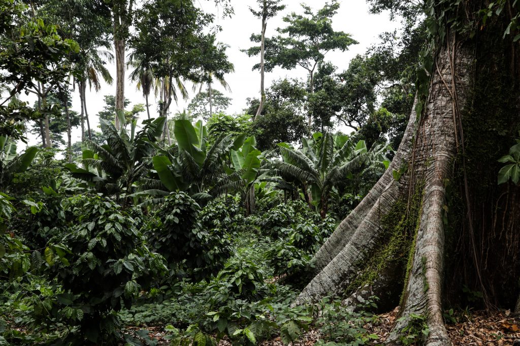
Coffee and sugar cane are major crops in the south-central region. Coffee plants are the shrubs, with banana and lumber trees providing shade. The large trunk belongs to a “ceiba,” the national tree of Guatemala. In Mayan culture, the ceiba connects the underworld to the heavens.
One region with two newly-launched roundtables is the western highlands of Guatemala. Unlike the predominately monoculture land in the south-central region, farmers here grow a variety of crops on many small plots.
Leaders of the regional community association of farmers (CDRO) met with representatives from Guatemala’s national meteorological service (INSIVUMEH), IRI and CIAT in March, ahead of the official launches of the Totonicapán and Quetzaltenango MTAs in May. A lot of planning, organizing and relationship-building must happen before an MTA can successfully launch. Photo: Diego Pons/IRI.
This photo captures the exterior of the Guatemala City office of Guatemala’s meteorological agency. The building is single story with an orange exterior, white railings and two green domes perched on the roof with a garden in front. A sign in the foreground of the photo identifies the building as a meteorological station as well as the latitude, longitude, and elevation (in Spanish).
Juan Pablo Oliva Hernández, the director of INSIVUMEH, provides welcoming remarks at the launch of the south-central roundtable.
For more on ACToday at IRI visit iri.columbia.edu/actoday. All images are by Elisabeth Gawthrop unless otherwise noted.
The Caribbean Climate Outlook Forum, also known as CariCOF, brings together climate scientists and meteorologists with decision-makers who may be able to use climate information. During the meeting, now held twice a year—once at the beginning of the dry season and once at the beginning of the wet season—the scientists present forecasts to experts in climate-sensitive sectors such as health, agriculture and water resources. The Caribbean Institute for Meteorology and Hydrology organizes the event.
CariCOF is one of many regional Climate Outlook Forums held around the world. The forecasts presented at COFs are usually seasonal forecasts for precipitation, though some regions present forecasts at other timescales, and some regions include other forecast products like temperature and outlooks for drought or food security. As explained by Simon Mason from the International Research Institute for Climate and Society in this Q&A, the forecast is produced through a consensus building process among national, regional and international climate experts. In most cases this occurs during a face-to-face meeting of the forecasters immediately prior to the COF.
“The National Oceanic and Atmospheric Administration (NOAA) and the European Commission sponsored the first COFs in southern Africa in 1997 as a way to bring together national meteorological and hydrological services, other national centers of expertise and regional and international institutions. IRI was involved from the very start, helping to shape the purpose and procedure of the meetings. COFs quickly spread to other parts of Africa as well as South America. Thanks to strong support from the World Meteorological Organization, they have now expanded to cover most parts of the habitable world.”
The Dry Season 2015 CariCOF was held in St. Kitts in late November 2015. It was sponsored in part by the Programme for Building Regional Climate Capacity in the Caribbean (BRCCC Programme), a three-year project made possible with the generous support of the American people through the United States Agency for International Development. Other sponsors included Environment Canada and the National Oceanic and Atmospheric Administration. The photos and videos on this site were all taken during that event, unless otherwise noted. For more on previous CariCOF events see the below links.
June 2015: Wet Season Outlook, Castries, St. Lucia
At the heart of CariCOF are the forecasts. Scientists gather for several days before the event to learn new techniques, discuss challenges in forecasting and come to a consensus on the current forecast. They then present the forecasts to decision-makers in sectors such as health, water and agriculture. The climate scientists also take time to get feedback from the decision-makers on the presentation of the forecasts as well as what other kinds of climate information might be useful.
Why CariCOF?
In the videos below, participants explain why they attend CariCOF, what they get out of it and why they think it’s needed.
Drought’s No Game
Drought is a recurring issue in the Caribbean, and one that directly impacts the essential economic sectors of agriculture and tourism. Other impacts of drought are less obvious, such as flooding vulnerability in Dominica. As water rationing becomes a reality in some countries, resource-intensive desalination plants are looked to as an option.
While most climate scientists understand the technical aspects of drought, many are less familiar with how decisions are made to direct resources in preparing for and alleviating the impacts of drought. A drought tournament activity at CariCOF illuminated some of the options and constraints for policy-makers dealing with drought.
Research and Innovation
As the twice-annual CariCOF events continue, scientists and decision makers want to improve the research that leads to forecast innovations as well as communication of existing climate-related information. Here are some participants’ outlooks on best practices and ways to move forward.
Shared Experiences: 20 Years of Climate Services and Framing the Next Steps in the Research and Development for Climate Resilience
Since early 2015, experts have monitored the development of one of the largest El Niño events of the last 50 years, and notably, the largest since the 1997-98 El Niño that shocked global food, water, health, energy and disaster-response systems and erased years of development gains. The current El Niño, which peaked at the end of 2015, offered a unique opportunity for governments, scientists, economists, humanitarian agencies, development professionals and the media to share perspectives on the transformation of climate forecasts to climate services in the past two decades. It allowed the expert community to focus attention on framing next steps in climate-services research, which are critical for achieving the sustainable development goals. Climate doesn’t act in isolation. We need to understand the interaction climate has with socioeconomic and ecological systems in order to address its negative impacts, as well as take advantage of times when climate conditions are favorable.
Key conference objectives
Provide an overview of the 2015 El Niño and its potential impacts
Examine the progress over last 20 years in international, national and regional climate services, with a focus on El Niño
Foster a dialog between high-level scientific experts and development practitioners on next steps for the research and development
Explore the connection between the current El Niño and Global Change
In November 2015, the International Research Institute for Climate and Society at Columbia University, in collaboration with the World Meteorological Organization, the U.S. Agency for International Development and the U.S. National Oceanic and Atmospheric Administration convened the El Niño 2015 Conference. Other members of the organizing committee included scientists from Centro Internacional para la Investigación del Fenómeno de El Niño, Indian Institute of Tropical Meteorology, and the Australian Bureau of Meteorology. The Conference received additional sponsorship from the Earth Institute, as well as the Initiative on Extreme Weather and Climate at Columbia University and the Reinsurance Association of America. The two-day gathering provided a platform for strategic dialogue to evaluate the big picture and ask questions related to El Niño, extreme events and variability on multiple time scales, including long-term climate change. The sessions were a combination of lectures and panel discussions designed to foster insight and interaction between attendees.
While conference attendance was limited to direct invitation, an additional 3,000 people viewed the proceedings via live-streaming and recordings. Outreach efforts on Twitter by our communications teams and dozens of participants yielded a potential reach of nine million people for the #elninoconf hashtag. We are grateful for the hard work and support by our staff, partners, sponsors and volunteers, as well as the enthusiastic participation and interaction of our invited speakers and attendees. They made the conference a successful event. We trust that the conference has served as a launching pad for new ideas, discussions, and collaborations that will continue to develop far beyond those two inspiring days in November.
Sincerely,
Lisa Goddard
Director, International Research Institute for Climate and Society
The Earth Institute, Columbia University
Opening Remarks
Given by Maxx Dilley on behalf of Jerry Lengoasa, Deputy Secretary-General World Meteorological Organization.
Ladies and Gentlemen, good morning.
It is a great pleasure to open El Niño 2015 Conference on the occasion of the 20th anniversary of the International Research Institute for Climate and Society—a key institution that I would like to thank for making climate science and information available for the benefit of society, and for being such an important collaborator with WMO in many areas.
I would like to thank all the other partners of WMO and the co-sponsors that made this conference possible: NOAA and USAID, Columbia University and the Reinsurance Association of America. Thanks also to the other members of the organizing committee—the representatives from the Centro Internacional para la Investigación del Fenómeno de El Niño (CIIFEN), the Indian Institute of Tropical Meteorology, and the Australian Bureau of Meteorology.
I am confident that the Conference will share lessons learned from managing El Niño impacts, develop key messages about this event for policy makers, practitioners and the public, and identify directions for future work in climate services for El Niño. For this reason, participants include not only climate scientists but also experts engaged in translating climate information into action for societal benefit.
This meeting coincides with one of the strongest El Niño events since 1950. It is a timely opportunity to reflect on what has been learned since the last major event in 1997-98 and to identify additional needs for improving climate services going forward. In the intervening nearly two decades since the 1997-1998 event, an enormous effort has been made to improve El Niño modeling, develop enhanced seasonal climate predictions, and to establish systems for making that information available in useable form.
WMO has contributed to this effort through its network of National Meteorological and Hydrological Services, its support for National Climate Forums and National Climate Outlook Forums, its Regional Climate Centres and support for Regional Climate Outlook Forums, and its Global Producing Centres for Long-range Forecasts. The RCOFs, started in advance of the 1997-98 event, have become a global institution, with on-going forums covering most of Africa, Asia and the Pacific, Central America and the Caribbean, South America and the Greater Mediterranean Region.
This El Niño will be an important test of the efficacy of those measures. Clearly the world is more informed about El Niño and its impacts than it was 20 years ago. Information about this event and measures that can be taken to improve related socio-economic outcomes are also considerably more accessible than previously.
The Conference is an opportunity to identify specific priority actions that can be taken to help society prepare and to develop shared recommendations on El Niño messaging for development and practitioner communities as well as the public. The Conference can also enrich the discussion about long-term needs for improving climate services, in which El Niño and seasonal climate forecasts play an important role.
A principal vehicle for this is the Global Framework for Climate Services, which many of you have contributed to conceiving and launching and some are now working to implement. The GFCS provides a structure for systematic delivery of climate information and therefore has the potential to benefit from and assimilate the findings from the Conference. Your ideas as to how the GFCS can support the delivery of information about El Niño, its climate effects, impacts, and guidance on managing them will be directly relevant to its future implementation.
I am confident that the wealth of knowledge and experience represented at the Conference will generate new ideas and directions that will assist in managing the impacts of this event and those in the future. With the UNFCCC COP21 only weeks away, I assure you that WMO will do everything possible to take the climate services agenda, including the results of this meeting, forward during the UNFCCC negotiations and thereafter.
9:00 – 9:10 – Opening Remarks: Jerry Lengoasa, Deputy Secretary-General, WMO (Read by Maxx Dilley)
9:10 – 10:30 – PANEL: 20 Years since the International Forum on Forecasting El Niño and Launching IRI (Moderated by Jim Buizer, University of Arizona) | Michael Crow, President Arizona State University (via video) | Mark Cane, Columbia University | Mickey Glantz, University of Colorado | Mike Hall, Retired NOAA
11:00 – 11:30 – Implications of a large El Niño event on global economy and development. Jeff Sachs, Director, Earth Institute – Columbia University
11:30 – 11:50 – Update on 2015 El Niño event. Michelle L’Heureux, NOAA-Climate Prediction Center
11:50 – 12:10 – Associated extreme climate impacts and their certainty. Adam Sobel, Columbia University
12:10 – 12:30 – ENSO modeling and prediction: Evolution and Outstanding Challenges. Lisa Goddard, CLIVAR-WCRP; IRI, Columbia University
13:30 – 14:00 – Overview structure of available ENSO information & coordination – from a WMO perspective. Maxx Dilley, WMO
14:00 – 15:00 – PANEL: Overview structure of available ENSO information and coordination (Moderated by David Corcoran, formerly NYTimes Science Times) Zinta Zommers, UNEP | Richard Choularton, WFP | Sezin Tokar, USAID/OFDA | Stewart McCulloch, WorldVision International
15:30 – 17:00 – PANEL: Case Studies on current event information, plans as well as current and anticipated impacts. (Moderated by Simon Mason, IRI, Columbia University) Latin America: Rodney Martinez, Centro Internacional para la Investigación del Fenómeno de El Niño, Ecuador | Peru: Ken Takahashi, Instituto Geofísico del Peru | Caribbean: David Farrell, Caribbean Institute for Meteorology & Hydrology, Barbados | Greater Horn of Africa: Guleid Artan, IGAD Climate Prediction & Applications Centre, Kenya | India: Sulochana Gadgil, India Meteorological Department | Philippines: Tony Lucero, Philippine Atmospheric, Geophysical and Astronomical Services Administration
17:00 – 18:20 – PANEL/Plenary Discussion: Messaging on El Niño – How do we inform the public (who informs what public), and what do they hear? How has this evolved over the last 10-20 years? (Moderated by David Herring, NOAA) Journalists in developing countries: Patrick Luganda, Network Climate Journalists in the Greater Horn of Africa | Societal perceptions of forecasts and risk: Mickey Glantz, University of Colorado | Communicating climate information: Eric Roston, Bloomberg News
Wednesday, November 18, 2015
9:00 – 9:30 – El Niño and Global Change. Marc Levy, CIESIN, Columbia University
9:30 – 10:50 – PANEL: Sectoral impacts of El Niño – What have we learned since 1997-98. (Moderated by Roger Pulwarty, NOAA) Health: Madeleine Thomson, IRI, Columbia University | Water: Upmanu Lall, Columbia Water Center, Columbia University | Disasters: Carina Bachofen, Red Cross Red Crescent Climate Centre | Energy: Alberto Troccoli, U. East Anglia
11:20 – 12:40 – PANEL: El Niño 2015 Response Strategy – what is or should be in place (Moderated by Heidi Cullen, Climate Central) Seasonal fire early warning system: Rizaldi Boer, CCROM-SEAP | Regional actions and support network: Jen Stephens, UNDP | Food Security: Amir Abdulla, World Food Programme | Insurance: Megan Linkin, SwissRe
13:40 – 15:00 PANEL: What is needed to evolve science towards increased societal benefit? (Moderated by Francesco Fiondella, IRI, Columbia University) Climate science: Simon Mason, IRI, Columbia University | Process of developing climate services: Jim Buizer, University of Arizona | Development banks: Kanta Kumari, World Bank | Social sciences: Ed Carr, Clark University | Agriculture: Andy Jarvis, CIAT
15:30 – 16:00 – WCRP/CLIVAR efforts to understand El Niño in a changing climate. Eric Guilyardi, IPSL-France
16:00 – 16:30 – The Intersection of El Niño and Climate Change – El Niño’s contribution to 2015 global temperature. Kevin Trenberth, NCAR
16:30 – 17:00 – El Niño, ecosystems for & carbon. Miguel Angel Pinedo-Vasquez, EICES, Columbia University; CIFOR
17:00 – 18:00 – PANEL: Young Scientists: exploring new ideas to connect research, the operational communities and the users: “reinventing climate services” (Moderated by J. Michael Hall, Retired Director of NOAA’s Office of Global Programs)Teddy Allen, IRI, Columbia University | Ãngel Muñoz, IRI, Columbia University | Aisha Muhammad, IRI, Columbia University | Roop Singh, IFRC Climate Centre
18:30 – 18:45 – Wrap Up, Final Remarks. Kathy Jacobs and Lisa Goddard
Post-Summit discussion of the Organizing Committee: Synthesize key messages and agree on report structure.
PANEL: Looking Back to Move Forward
20 Years since the International Forum on Forecasting El Niño and launching IRI
Michael Crow,Arizona State University (via video) |Mark Cane, Columbia University| Mickey Glantz,University of Colorado| Mike Hall,Retired NOAA| Moderated by Jim Buizer,University of Arizona
The opening panel of the conference consisted of pioneers in the field of El Niño-Southern Oscillation (ENSO) forecasting, ranging from those in academic administration and government who identified and supported the need for “outcome-based science,” to one of the physical modelers who provided a foundation for the ENSO forecasting, to the critical social scientists who helped bring ENSO forecasting to the end user.
“Plans are worthless, but planning is everything,”
President Eisenhower, and Mike Hall at #ElNiñoConf
The coupling of “simple” ocean and atmospheric models in the Cane/Zebiak ENSO model was considered groundbreaking, significantly contributing to the future of not just ENSO forecasting, but climate forecasting in general. In Mike Crow‘s discussion about the early days of the formation of the IRI, he mentioned the importance of translating scientific information for use beyond the scientific community. Crow stressed the importance of the transition from weather forecasting to climate forecasting, and noted that the development of scientific tools should contribute to mid- and long-term decision-making in the economic and political spheres and enhance quality of life. Crow referred to this as “outcome science,” in which the objective is to seek an outcome. He hopes someday there will be a network of institutions focused on this kind of science, and that scholars across many disciplines will be involved.
"Outcome science" is where science isn't the objective itself, the outcomes are. Outcomes like sustainability. ~@michaelcrow#ElNinoConf
— USAID's Bureau for Humanitarian Assistance (@USAIDSavesLives) November 17, 2015
Mark Cane provided anecdotal context around the first ENSO forecast. He recalled the skepticism at the time from broader climate science community towards the first Cane/Zebiak model results and subsequent forecast, and he reflected on their hesitancy to release the El Niño forecast in 1986. Interestingly, this type of push-back is not uncommon across many technical and scientific fields, but is particularly relevant in the fields of climate science and climate mitigation engineering. Within the context of the first ENSO forecast, Cane framed the discussion around “What if you are wrong?” versus “What if you are right?”— two seemingly straightforward questions that have complex, far-reaching answers.
Mickey Glantz discussed the critical requirement of the social science component to climate forecasting and emphasized that climate science doesn’t stop at the results from the physical models. Without the ability to carry the message beyond the physics to the relevant stakeholders and other users of El Niño information, the impact of the scientific or technical findings will be lost in the lack of translation or communication. A third end to the traditional end-to-end concept must be made explicit: that is, the forecast and research community must solicit input from stakeholders and other users of El Niño forecasts and warnings about their effectiveness and about what forecast information must include.
Glantz memorably named some of the significant El Niño events that have occurred over the last 150 years, namely:
Q&A highlight
What would you like to be a turning point from this conference that really made a difference to how we conceive development today?
Answers:
Hall: We need to really work at interdecadal variability and modes of variability and need to address North Atlantic thermohaline circulation.
Glantz: ENSO can serve as link between “here and now” and climate change adaptation. Disaster relief efforts are inadequately tied to preparation and that we need “resilient adaptation”—not preparing for the future so much as constantly preparing and adapting.
Cane: We need to develop trust, we can’t worry just about the next 100 years but the next year, the next decade. There used to be a prohibition against talking about adaptation instead of mitigation. Now we can talk about adaptation, but need to talk about adaptation to climate in general, not just climate change.
1877-78 El Niño.
1891: the downwelling phenomenon was first named “El Niño” at a conference in Lima, Peru. By 1982, this event was being described as the previous “biggest El Niño.”
1957-58: “The International Geophysical Year (IGY) El Niño“ Project to investigate coastal upwelling processes off the west coast of the US and Peru.
1972-73: “The El Niño of the Scientists“ The collapse of Peruvian fisheries, and the identification of the ENSO teleconnections generated scientific concern.
1982-83: “The El Niño of the Governments” This El Niño was labeled the “El Niño of the Century” and generated awareness of El Niño as an economic threat to many governments, funding for monitoring increased.
1997-98: “The El Niño of the People” People around the globe became aware of the El Niño phenomenon.
2015: “The El Niño of Response and Preparedness” Naming this event a “Godzilla” El Niño did a disservice to the the seriousness of forecasting and raised expectations of potential impacts that fell short of reality.
Continuing with the overall theme of this panel, Mike Hall discussed the evolution of climate services and proposed the idea of a National Climate Service, stating that as with weather, constant assessment is necessary. He emphasized the importance of planning, stating that planning is what prepares you for the eventuality—for being able to adapt, adjust and continue to move forward.
Hall named three key drivers that led to the creation of the IRI: 1) the implementation of general circulation models capable of capturing climate phenomena, 2) the application of physical science to “real people’s real problems” and 3) identifying the value and necessity of incorporating social science as an integral component to the overarching climate science realm. These three drivers summarize the key points as discussed by the other members of the panel, with each member providing context from his specific discipline.
Kathy Jacobs from @UofA on turning past lessons into future progress: you can’t let the rules define what you can achieve. #ElNinoConf
Jeff Sachs, Michelle L’Heureux, Adam Sobel, Lisa Goddard and Maxx Dilley
Implications of a large El Niño event on global economy and development
Jeffrey Sachs Director, Earth Institute, Columbia University, Tuesday, November 17, 2015
Key topics presented:
Links between El Niño and global economy
El Niño’s compounding influence in areas already in crisis
Effect on agriculture can lead to local shocks
El Niño impacts in middle-income countries could be tipping points for global-level economic crisis
Some regions of particular concern for instability
Several major El Niño events over the last 40 years (1972-73, 1982-83, 1997-98) have been associated with global macroeconomic crises. While there isn’t necessarily a tightly-coupled relationship between El Niño and the global economy, the impacts associated with El Niño teleconnections are potentially destabilizing, given the underlying states of geopolitics and economies.
Jeffrey Sachs outlines the economic crises that could accompany the current El Niño weather pattern.
At the global scale, Sachs said there are two big macroeconomic risks: simultaneous crops failures or other ENSO-related emergencies in impoverished countries; and tipping points in several middle-income countries already on the edge of crises.
ENSO can act as a shock or a crisis amplifier to countries that are already politically or financially stressed. For example, in poor countries with weather-dependent agriculture that have little buffering to shocks of ENSO, the shocks may lead to local conflict. The potentially more far-reaching economic effects are those in middle-income countries, where El Niño is an additional force that affects instability.
With respect the 2015-16 El Niño event, there are regions of instability significant enough that the El Niño teleconnections could create new tipping points or positive feedbacks that could be globally destabilizing. These regions include Middle East and North Africa,Southeast Asia (ASEAN countries), the Horn of Africa, South Africa and South America. In these regions, the impacts of El Niño have the potential to compound the effects of ecological vulnerabilities, geopolitical tensions and financial instabilities.
Michelle L’HeureuxNational Oceanic and Atmospheric AdministrationTuesday November 17, 2015
Key topics presented:
Definition of El Niño: historical and real time
ENSO interacts with short-term variability (Madden-Julian Oscillation) and long-term warming
Comparison of sea-surface temperatures, subsurface temperatures, winds, sea level pressure and precipitation in 2015 and 1997
Comparative challenges that models had in 2014 and 2015 forecasts
L’Heureux’s talk focused on the characteristics of the 2015-16 El Niño event and how it has evolved. She pointed out that in a historical sense, NOAA defines El Niño by looking at the 3-month average of Niño 3.4 over five consecutive months. Operationally, however, the agency doesn’t have the luxury of waiting eight months to determine if there’s an El Niño, and therefore has to bring in other measures.
Event centered farther west than 1997/98, so teleconnections may be dif! L'Heureux: Niño3.4 warm, Niño4 bananas (paraphrase). #ElNinoConf
Sea-surface temperatures in the Niño 3.4 give only some indication of an El Niño’s strength. For example, sea-surface temperatures in the Niño 3.4 region are comparable between the 2015-16 and 1997-98 events, but other indicators, including atmospheric components, point to 1997-98 being a stronger event.
Associated extreme climate impacts and their certainty
Adam Sobel Initiative on Extreme Weather and Climate, Columbia University, Tuesday November 17, 2015
Key topics presented:
There is no particular evidence that there are more disasters during El Niño years.
Disasters are more predictable during El Niño years – we can see them coming.
ENSO does make some extreme things happen that would be unlikely otherwise.
Likelihood increases for active tropical cyclone season in the Pacific.
El Niño and California drought
Indonesia fire season one of the worst during this El Niño episode
Predictability of noncanonical sea-surface temperature features related to this El Niño
.@profadamsobel: Not a greater # of disasters in El Niño years, but more predictable, alter odds of certain extremes #ElNinoConf
Sobel’s talk focused on extreme climatic impacts associated with El Niño and their potential predictability. The onset of an El Niño event doesn’t amplify the magnitude of every disaster, but it can cause extreme events to occur. Sobel also mentioned several other associated atmospheric anomalies with currently unknown relations to El Niño episodes, and questioned the potential for predictability in these aspects.
Adam Sobel discusses the climate impacts of El Niño and the value of their predictability.
ENSO modeling and prediction: Evolution and outstanding challenges
Lisa Goddard CLIVAR-WCRP; IRI, Columbia University, Tuesday, November 17, 2015
Key topics addressed:
Challenges of modeling El Niño
Biases in models and assessment of current conditions
Challenge of representing physical climate processes faithfully
The amount of time/effort to improve forecasts is not insignificant, but payoff can be substantial.
The need for improvement on the characterization of risk and uncertainty in climate information
Goddard stated that missed forecasts provide the opportunity to improve models. Although the magnitude of the strong 1997-98 El Niño was accurately forecasted, challenges remain in predicting ENSO events and their impacts, as well as in acting on ENSO forecast information. Sea-surface temperature forecasts exhibit the highest skill in the El Niño region but lower skill in the western Pacific Ocean and the Indian Ocean. Other oceanic areas aren’t predicted well, even with a short lead time.
A decade of ENSO prediction research has bought us one additional month of prediction skill – and this is a lot. @GoddardLisa#ElNinoConf
Prediction systems consist of models, observational networks and data assimilation systems. Modeling challenges for El Niño include: 1) model biases, 2) biases and imbalances in the ocean-atmosphere state estimation and 3) representation of processes. Data assimilation challenges (e.g., from spotty observations and imperfect models) and the resulting initial conditions may lead to biases in the ocean-atmosphere state estimation. Poor characterization of wind variability is an example of a challenge in process representation.
.@GoddardLisa stresses importance of translating climate models into real on the ground impacts & then into meaningful action #ElNinoConf
— USAID's Bureau for Humanitarian Assistance (@USAIDSavesLives) November 17, 2015
Expected impacts do not quantify the likelihood of impacts; there is a need to translate model uncertainty into forecast risk or likelihood. Climate information can give decision makers objective and transparent ways to respond to El Niño impacts, but that climate information must be translated into socio-economic impacts and meaningful action.
Overview structure of available ENSO information & coordination—from a WMO perspective
Maxx Dilley World Meteorological Organization, Tuesday November 17, 2015
Key topics presented:
Climate Finance – funding sources
GFCS Meeting on Implementation Coordination
El Niño information leading to climate services, examples from Bhutan and Burkina Faso
Overview of the Global Framework for Climate Services including history, governance, priority areas and needs
Dilley began by introducing recent climate-related developments, such as the Sendai Framework for Disaster Risk Reduction, and he provided updates on the progress of the Sustainable Development Goals. A key priority is to attract investments in climate services to provide decision makers with better-tailored information.
Need to know decision making processes, then you can intervene precisely.
Maxx Dilley
He noted that disasters involving hydrometeorological hazards affect 55 times as many people and account for nine times the deaths and three times the economic losses as all other hazards combined.
Overview structure of available ENSO information and coordination
Zinta Zommers, United Nations Environment Program | Richard Choularton, World Food Program | Sezin Tokar, US Agency for International Development/Office of U.S. Foreign Disaster Assistance | Stewart McCulloch, WorldVision International | Moderated by David Corcoran, former editor, New York Times
David Corcoran contextualized this discussion by pointing out that many individuals outside of the conference attendees know little to nothing about El Niño, let alone coordinating available information around it. Corcoran admitted that he knew very little about El Niño prior to being asked to moderate the panel, despite his time as science editor at the New York Times. Awareness of El Niño Southern Oscillation (ENSO) may not be necessary for some individuals, but there are decision makers across sectors (e.g. water and energy), who could utilize ENSO information (and climate information generally) to inform and improve their decision-making processes.
We’re sorry, due to technical issues with our livestream provider, we are unable to provide a video of this panel.
Corcoran asked the panelists to describe the human dimension of El Niño and how it affects the work their organizations do.
Zinta Zommers stated that the focus of the UNEP is through the lens of ecosystems to evaluate impacts on both ecosystems and society. She said that during El Niño years UNEP works with governments to build capacity on designing better early-warning systems, to understand the role of ecosystem services in disaster-risk reduction and to foster south-south learning.
Sezin Tokar explained that USAID OFDA leads disaster response abroad for US government. In recent years OFDA has responded to 65 disasters in 55 countries, e.g. Ebola response, Haiti earthquake response. The office also supports disaster-risk reduction, improved early warning systems and preparedness. During the 1997-98 El Niño response, OFDA responded to 22 El Niño related disasters as well as engaged in climate outlook forums and worked with policy makers and practitioners to use climate information.
Climate info fairly easy 2 get. Vulnerability & exposure info harder. Rely on our disaster experts & partners in the field~Sezin #ElNinoConf
— USAID's Bureau for Humanitarian Assistance (@USAIDSavesLives) November 17, 2015
Stewart McCulloch said World Vision International works in 100 countries. He described microfinance initiatives that help one million families and a project funded by the UK’s Department for International Development that is issuing microfinance loans to enhance recovery efforts.
Richard Choularton stated that WFP provides food aid to 80-100 million people each year. He also said that hunger and poverty are underlying issues exacerbated by climate shock. WFP helps people respond to climate disasters, and the only way it can do that is to understand the links between climate and food security and get better about acting. He noted that he is vice chair on the Global Framework for Climate Services’ Partners Advisory Committee, which enables him to listen to the conversation and drive the agenda in a meaningful way from the users’ perspective. “We don’t need scientists telling us what we need to know, we need to inform them on what information we need to make decisions,” he said.
“Is early warning a human right?”
Sezin Tokar
The panelists also acknowledged climate risks and challenges that lie ahead, including vulnerabilities associated with reliance on rain-fed agriculture in many places. They posed some fundamental questions moving forward. For example, Zommers asked, “Is early warning a human right?” Tokar asked at another instance, “How do we get policy makers, practitioners and disaster managers to use climate information?”
Corcoran asked the panelists about how their organizations get information, the quality of the information and how they disseminate it.
Fave comment of #ElNinoConf is from @RChoularton, @WFP: We can handle the uncertainty, let us make the decisions about how to incorporate it
Choularton said WFP has a very sophisticated early warning system that includes climate and weather information. Over the years it has enhanced its understanding about the quality of the information and how to translate it into impacts. Determining the usefulness of the climate information—for example, the level of uncertainty associated with seasonal forecasts—is a significant task.
WFP reconstructed its early-warning and risk-assessment processes to include a chain of scientists and technical specialists who can filter the information before it is passed along to decision makers. These experts come from the World Meteorological Organization, national meteorological services and regional climate centers, as well as from technical food security partners.
Limitations with forecast certainty were highlighted to WFP in 1997-98, when the organization was ultimately criticized for planning for a drought in southern Africa that never materialized. He underscored the importance of forming relationships and processes over time that allow science partners to provide information to WFP technical staff who can send this to policy makers.
USAID OFDA relies on national meteorological services, NOAA and regional climate centers for information. Translating that information into response is often the trickiest part, said Tokar, who acknowledged that the vulnerability and exposure portions of risk calculations are often more difficult to predict than the climate conditions. Like Choularton, Tokar and later McCulloch stressed the need for reliable networks of experts, regional partners, NGOs, UN agencies and disaster management agencies from which to draw knowledge and information. She also said the information being provided could be more crisp and tailored.
Zommers noted that a lot of work goes into repackaging climate information for public consumption. She encouraged those organizations that operate in the space between climate information producers and users to relay information in a way that maximizes the diversity of potential climate information users. She also said that sometimes constituents trust religious institutions and NGOs more than government sources of information.
Zommers: "Need to strengthen the links between scientists and the UN system" #ElNinoConf
Relatedly, McCulloch stressed that suppliers of studies and data should communicate more with the nongovernmental organizations and other non-scientific groups. At some point, the individuals on the ground have more pertinent information than the scientists, he noted.
“You can’t be a good supplier of information if you don’t understand the need,” said McCulloch, and similarly, “if people don’t understand how to use the information it isn’t going to be used well.”
Stewart McChulloch of @VisionFund, @WorldVision: one strength we have- lots of ppl in areas where many want to know conditions. #ElNinoConf
In response to a question regarding the media’s role in covering El Niño, Tokar and Choularton noted that the media does a great job of bringing awareness to issues including El Niño. On the other hand, the media can sensationalize stories and often fails in communicating the uncertainties associated with possible impacts of El Niño. Tokar noted that the sensational media treatment of the potential “Godzilla” El Niño in 2014 placed USAID in a difficult position.
The panelists cited the need for better media accountability to represent uncertainties. Everyone agreed that it would be hard to imagine a news anchor explaining that there is a 75% chance that a moderate-to-strong El Niño event will occur in the upcoming winter months and that, as a result, there is a 60% chance a region will experience above-normal precipitation. It may be helpful to create and disseminate tailored talking points to news agencies which avoid the “monotone bore” often associated with scientific explanation but still retain the meaningful information associated with seasonal forecasts.
The panel provided a great opportunity for physical scientists in the audience to understand the perspectives of the organizations that depend on climate information products such as seasonal forecasts. The panelists suggested that going forward more communication is necessary between physical scientists who create climate products, organizations that filter and disseminate information and end users. In this way, the work done by the physical scientists can be better targeted and translated into appropriately flexible, useful products.
PANEL: Current Event Case Studies
Case Studies on current event information, plans as well as current and anticipated impacts
Rodney Martinez, Centro Internacional para la Investigacion del Fenomeno de El Niño (CIIFEN), Equador |Ken Takahashi, Instituto Geofisico del Peru | David Farrell, Caribbean Institute for Meteorology and Hydrology (CIMH), Barbados |Guleid Artan, IGAD Climate Prediction & Applications Centre (ICPAC), Kenya |Sulochana Gadgil, India Meteorological Department | Tony Lucero, Philippine Atmospheric, Geophysical and Astronomical Services Administration| Moderated by Simon Mason, IRI
We’re sorry, due to technical issues with our livestream provider, we are unable to provide a video of this panel.
Six international experts convened for this panel session to discuss how El Niño is addressed in their respective climate service organization. Overall, two common themes emerged among the panelists: identifying seasonal climate and weather variability during an El Niño event and communicating its impacts.
El Niño can have both local and regional impacts. The Caribbean region experienced one of the strongest droughts on record during the summer of 2015, and water resource deficits are expected to continue into the winter dry season. Water demand during the dry season is compounded by the increasing number of tourists that visit the Caribbean during the popular winter months. Thus, David Farrell from CIMH suggested a more integrated method to develop water-resource decisions is needed in order to sustain the local population while supporting the lucrative tourism industry. While the seasonal climate impact from El Niño is regional throughout the Caribbean, local convection-scale impacts are observed in other parts of the world, such as in the Philippines. Tony Lucero noted that the strong likelihood of reduced rainfall during an El Niño event increases the risk of drought in the Philippines. The most severe droughts the country experienced over the last several decades occurred during the strong El Niño events of 1982-83, 1986-87 and 1997-98.
Peru, on the other hand, experiences impacts from both local and remote forcings. Ken Takahashi, in representation of ENFEN (the official Peruvian El Niño assessment committee), noted that regional impacts along the Peruvian coast, such as heavy rainfall and flooding in this otherwise arid region, depend on local sea surface temperature (SST; e.g. Niño 1+2 region), while remote warming in the central Pacific (e.g. Niño 3.4 region) can lead to rainfall deficit in the Peruvian Andes and Amazon. The difference between remote and local effects imply a strong sensitivity of the impacts to the El Niño pattern and strength. However, the large diversity among events (e.g. eastern Pacific vs central Pacific El Niño) makes it difficult to assess the El Niño impacts in general. Particularly, the very large eastern Pacific warming during El Niño in 1982-83 and 1997-98 produced rainfall equivalent to the other forty rainiest years combined in northern Peru.
Thus, for decision making in Peru, it is critical that “El Niño” is not used as a catch-all phrase but that potential impacts are assessed considering both the SST pattern and strength, for which ENFEN uses both Niño 1+2 and Niño 3.4 SST as its main reference indices. Information from reliable foreign sources using less nuanced definitions continue to generate confusion in the Peruvian population and authorities.
CIIFEN, based in Ecuador, and ICPAC in Kenya were developed to improve climate services at regional scale to contribute on risk management and adaptation. CIIFEN emerged after the 1997-98 El Niño from the demand to develop and communicate El Niñ±o impact information for decision makers in Latin America and is now a designated WMO Regional Climate Center.
Rodney Martinez of CIIFEN said it is crucial to communicate the diverse impacts of El Niño while emphasizing the regional and national particularities which could help minimize confusion. He highlighted how much the similarities of the current El Niño with previous events could help people better understand the potential impacts. Also potentially useful to strengthen the interface with policy makers is to quantify El Niño’s effect, e.g., impact on gross domestic product or other sectorial and social indicators. The scale factor could trigger decision making and foster climate services requests/provision at national level. Limited but clear climate information, successfully delivered, could make the difference to enhance users’ responses and mitigate El Niño’s impacts. The poorest segments of the population are the least informed, Martinez noted.
ICPAC was established in 1989 in response to prolonged drought in East Africa during the 1970s-1980s. Guleid Artan said the current event is unlikely to be similar to the 1997-98 one for Kenya, but it still faces the risk of devastating floods. Both CIIFEN and ICPAC work to apply local scales of knowledge from information provided by larger global forecast centers to monitor and forecast hydrologic variability related to El Niño.
In some cases, such as India, the government responds directly to climate service information on critical phenomena such as droughts of the monsoon by the India Meteorological Department. The seasonal forecasts of a drought of the Indian summer monsoon rainfall in 2015, issued by this national service, proved to be very accurate. Sulochana Gadgil mentioned that the government of India developed a cell under the cabinet of secretary to monitor drought and advise about agricultural strategies and water management during the El Niño drought of 2002. This cell was also used to tackle the droughts of 2009, 2014 and 2015.
The importance of integrated decision making was discussed by all of the panelists. Better integration can stem from, for example, networks of regional consortiums, improved national political structure or interaction between national sectors. A second topic of discussion centered on the use of analogs to compare current events to historical events of similar magnitude. The obvious example during this session was the comparison between the 1997-98 El Niño and the current El Niño. Physically, no two El Niño events are alike, which can cause exact comparisons to be misleading. However, memory between similar events makes impact communication easier for each of the organizations represented in the panel.
PANEL/Plenary Discussion: Messaging on El Niño
How do we inform the public (who informs what public), and what do they hear? How has this evolved over the last 10-20 years?
Patrick Luganda, Network Climate Journalists in the Greater Horn of Africa | Mickey Glantz, University of Colorado | Eric Roston, Bloomberg News | Moderated by David Herring, Director of Communication and Education, Climate Program Office, NOAA
David Herring introduced the topics to be discussed by asking whether people outside the science community would identify the commonalities between, for example, crop failures and Indonesian fires in 1998. He argued that in the 1980s and 1990s, the public became more aware of El Niño and its impacts, partly due to both the media and scientists becoming better communicators of science. He then asked the panelists and audience to comment on how science communication has evolved in recent years.
We’re sorry, due to technical issues with our livestream provider, we are unable to provide a video of this panel.
Comments from the audience related that El Niño Southern Oscillation (ENSO) information exists, but does not necessarily reach the public and when it does it may not be in a useful or “actionable” form. The audience also questioned what is considered useful; different public sectors might interpret utility in different ways. Additionally, communicating uncertainty is, in the view of some in the audience, still an issue that reflects on the science credibility.
The panelists were invited to state their views on communicating climate science.
Mickey Glantz questioned the usefulness for the public to understand El Niño. He noted the differences in the public’s understanding of climate information. Some are dismissive, while others are more attentive to the available information. Some are “gatekeepers,” having the task of informing the policy makers. And finally, there are the decision makers themselves. He also mentioned that if forecasting El Niño onset, for example, is hard and uncertain, this should be communicated to the public and labeled “experimental” while the regular forecast remains the main “operational” product. There is no silver bullet forecast that will please all. Glantz continued by asking scientists and science communicators to educate people about the consequences of ENSO, because the real first responders are the victims; they are the ones that need to take action when hazard is imminent. He also added that this year’s El Niño will hopefully be known as the El Niño of adaptation, or response, not the “Godzilla” El Niño.
Patrick Luganda stated that there is an assumption that victims need to be rescued, as El Niño is portrayed to bring losses and there is a lack of communication about opportunities. He added that early intervention has proved successful, citing the example of Red Cross intervention in Uganda to prevent losses from floods. He explained that ordinary people translate scientific jargon into their own language and understand that two ENSO events are not the same. Luganda concludes that scientists and science communicators should learn from communities, and that there is generally need for more scientists and media involved in getting the stories across.
"Information going out [about El Niño], not taking into account the type of information end users need" @pluganda#ElNinoConf
Comments from the audience echoed Luganda’s assessments. One participant mentioned communities in Kenya taking advantage of floodwaters upstream to their benefit, while another participant mentioned that understanding how civil defense agencies work increases the usefulness of the forecast.
Q&A Highlight
Could this El Niño help get people interested in climate change?
Roston: There is immense appetite for ENSO news, especially from investors.
Talks in this conference have discussed response to extreme events and disasters, but is better preparedness the result of better communication or because people have adapted to previous events?
Luganda: Communicating disaster effectively can mean the difference between life and death. Delays in ENSO forecast can lead to food crisis, and there is little room for debating forecast, thus people tend to trust the information.
Roston: The way in which communicators reach people is as important as the information they’re trying to get across.
For whom are we communicating?
Luganda: In the US, food is in your pocket. Food is purchased from your wallet. For subsistence farmers, food is in your garden that responds to the environment. Quality and type of information differs depending on the audience.
Eric Roston was asked how media attention can help ENSO awareness, to which he responded, “Take facts and exaggerate!”
Roston cited some headlines that capture people’s attention, such as “Huge El Niño spreads mayhem around the world,” or others in which studies show relationships between extreme heat and low birth rates. He also alluded to the power of media to force action, recalling the case when problems with defective data buoys were solved prior to the release of a media report. Roston also argued that there are two interpretations to climate change: one that is political and another that recognizes climate change is happening, prompting industries and communities to change behavior accordingly. He added that while communicating climate information, one should get people interested by linking the topic to their own interests, and that data visualization drastically improves information dissemination, but it must be simplified. Finally, he noted that climate variability is a harder topic to understand compared to climate change.
Herring described his experience in trying to address very specific user’s questions related to the California forecast. He asked whether we are interacting with the public in a way that meets their needs. To that question an audience member asked whether regular forecast updates from the World Meteorological Organization are useful, to which Luganda replied that they are indeed useful and that there is a lot of confidence in those products. In his opinion, the physical science is doing well, but the social science needs to improve.
DAY 2
Wednesday, November 18, 2015
PANEL: Impacts
Sectoral impacts of El Niño – What have we learned since 1997-98?
Madeleine Thomson, International Research Institute for Climate and Society | Upmanu Lall, Columbia Water Center, Columbia University | Carina Bachofen,Red Cross Red Crescent Climate Centre | Alberto Troccoli, University of East Anglia| Moderated by Roger Pulwarty, NOAA
Roger Pulwarty framed both physical phenomena and the responses to those phenomena along a timescale continuum from subseasonal to centennial. For example, short term events can be forecast through early-warning systems, interannual events can alter our resource allocation and decadal to centennial events can alter infrastructure design. This set the tone for one of three main themes in the session, which were:
How each sector responds to climate variability across the continuum of time scales.
The necessity to focus on the connections between sectors. These problems are systems-level issues that cannot be sectioned off into compartmentalized aspects.
We need to disseminate information to users in a manner that is accessible and digestible.
Our Madeleine Thomson: We’re helping build nationally-owned, hi quality #climatedata across Africa to fill in data gaps. #elninoconf#ENACTS
Madeleine Thomson touched on this continuum in the context of making climate data available to users as a means to improve the decision-making process. She pointed out that much has changed since the 1997-98 El Niño—not only in our ability to predict its occurrence and impacts but also in social and economic development that underpins population vulnerability. She noted that in the case of malaria, precipitation and temperature influence the suitability of the vector carrying the disease. When ENSO alters the patterns of precipitation and temperature, forecast information can be applied to resource allocation and prevention efforts. This requires, however, that historical as well as current information is available to decision-makers. Such information has been lacking in many developing countries, but with new initiatives such as Enhancing National Climate Services, known as ENACTS, products and services are increasingly available online in a number of African countries. In Ethiopia for example, the government was forewarned about the likelihood of a significant drought in July-September 2015 and was much better prepared to respond than during previous extreme drought emergencies.
Upmanu Lall discussed how the water sector responds to risks, and why we may not be very good at responding to long-term risks. For example, due to operating procedures, politics and historical precedent, government agencies tend to take action only when information is very certain. So although water is a public good, we may need to turn to the private sector, which is more able to capitalize on probability and risk issues. The financial sector is a good example. Lall noted that every country is interested in economic productivity, and he stated that we need a linkage for structural elements of (climate) risk management that are backed up by financial instruments. But this isn’t very common in the infrastructure community. Reinsurers need to aim reinsurance at infrastructure since the construction and running of this infrastructure is on timescales divorced from decision making.
Carina Bachofen provided a prime example linking health, financial instruments and climate forecasts through the Red Cross Red Crescent Climate Centre’s initiative of Forecast Based Financing. She explained the shortfall of funding between short term disaster-response measures and long-term disaster planning. The Climate Centre is looking at how to release funding following a forecast but in advance of a disaster to mitigate risks by not needing to wait for the disaster to occur. Just before this conference, the Uganda Red Cross distributed non-food aid triggered by forecast-based financing that was made available by the climate forecast. In this way NGOs are looking to bridge the scales inherent in both the physical phenomena and in consequent responses.
Bachofen: Last week humanitarian history made: Uganda RC launched forecast-based financing to release $$ b4 disasters #ElNinoConf@RCClimate
Alberto Troccoli spoke about the impacts of climate on the energy sector, noting that supply and demand of energy are highly sensitive to variations in climate. When considering timescales for infrastructure development he stressed that we need to focus on the long term rather than the short term. Many companies currently develop solar or wind infrastructure based on between one and three years of data. But climate phenomena such as ENSO and other longer-term fluctuations and trends can significantly impact these energy sources via changes in incoming solar radiation, wind speeds and other variables, so estimates based on a few years may be misleading. He noted a few specific impacts of climate variability on the energy sector, including hydropower dam water levels in Kenya, heat waves and nuclear power production in France and flooding of coal mines in Australia. Troccoli said that action and discussion is moving through the Global Framework for Climate Services and the World Energy & Meteorology Council, and that there is an active community developing climate services for the energy sector.
Each panelist also spoke on the second theme—the necessity to consider these problems as systems-level issues. Lall framed his talk almost entirely as a systems-level problem, and he proposed that we start looking for systems-level solutions that may be outside of one specific sector. His example was to use financial instruments to fund infrastructure as a climate risk reduction measure. Bachofen focused on the need to develop standards for disaster risk reduction. Disasters tend to encompass climate, communities, finance and infrastructure. In this way we need a metric for these linkages so funders can be assured of the reliability of a project. Alberto brought up interconnectedness among sectors again in his concluding remarks. He stressed that we often have short and scattered observational records within sectors. We need to collaborate on this point since these observations really cut across sectors.
Bachofen spoke of the need to disseminate information using accessible media, the third theme that emerged from the panel. As an example, she showed an animation that brought together climate scientists, animators and celebrities to produce a number of short animations locally tailored to the public in Vanuatu about risks from ENSO and potential ways to prepare for the impacts. Bachofen also mentioned the initiative Building Resilience and Adaptation to Climate Extremes and Disasters (BRACED), in which multiple NGOs have come together to coordinate tailored information using webinars, online discussions, data portals etc. Thomson used the example of a climate data portal developed in conjunction with the Ethiopian government as a way of encouraging exploration of risks specific to Ethiopia.
TALKS: El Niño and Climate Change
El Nino and Global Change
Marc Levy Center for International Earth Science Information Network (CIESIN), Wednesday November 18, 2015
Key topics presented:
What makes this El Niño different in the global social, economic and political arenas
Social changes have many parallels to the dynamics of the climate system.
Exponential increase in social-driven pressures
Changes in climate as well as social and economic structures mean this El Niño is taking place in a different world than previous major El Niño events.
We are in a state of intense political transition.
WCRP/CLIVAR efforts to understand El Niño in a changing climate
Levy’s talk focused on how the 2015-16 El Niño has unfolded given the different global context compared to past El Niño events. Impacts of climate are felt in the social, economic and political realms. With a rapid increase in socially-driven pressures such as globalization, population change and political transitions, Levy argued that our world today is less El Niño-resilient than during the 1997-98 event. Risk profiles of nations and individuals have changed, and the potential damages of the El Niño are worse than before.
WCRP/CLIVAR efforts to understand El Niño in a changing climate
Eric Guilyardi IPSL/LOCEAN – France, and NCAS-Climate/University of Reading – United Kingdom, Wednesday November 18, 2015
Key topics presented:
CMIP3 model biases are substantial, underestimating both Bjerknes wind stress feedback and heat flux response.
There is no clear improvement of the biases going from CMIP3 to CMIP5.
Without enough statistical data, we have to rely on physical understanding and process-based metrics.
New research is focusing on the role of the atmosphere and climate dynamics.
The TAO-TRITON array has been essential to ENSO progress. Updates to that observing platform presents a unique opportunity to design something ambitious, but the community must proceed with caution when making fundamental changes.
The Climate and Ocean: Variability, Predictability and Change project, or CLIVAR, is one of the four core projects of the World Climate Research Programme. Guilyardi introduced CLIVAR’s objectives in its study of changes in the Earth’s climate system.
As no two El Niño events are alike, statistics alone don’t help us understand changes in the El Niño-Southern Oscillation. A minimum of 250 years of observational data is required for simulations to statistically distinguish changes in ENSO amplitude. Guilyardi made a case for moving from a sea-surface temperature performance metric to process-based metrics in studying ENSO and the likelihood of extreme El Niños in unmitigated climate change.
The Intersection of El Niño and Climate Change – El Niño’s contribution to 2015 global temperature
Kevin Trenberth National Center for Atmospheric Research, Wednesday November 18, 2015
Key topics presented:
Comparison of historical record of temperature, CO2 levels and ENSO
Quantification of El Niño’s influence on global mean temperature
Earth’s heat budget and ocean heat loss/gain during El Niño/La Niña
El Niño’s influence on the jet stream, floods and droughts
Global temperature and the Pacific Decadal Oscillation
Global warming and its impacts on frequency of El Niño events and intensity and frequency of floods and droughts
Trenberth from @AtmosNews: Only way we can explain teleconnections is through total Pacific activity, not just anomalies #ElNinoConf#ElNino
Trenberth discussed the relationship between climate change and El Niño. illustrated that El Niño Southern Oscillation (ENSO) is the main source of interannual variability in global mean temperature. La Niña and El Niño events also affect floods and droughts around the world. He brought up the question of how best to measure the state of El Niño and its impacts. Trenberth also provided evidence of global warming and discussed the interaction between climate change and El Niño. He noted that climate change could potentially lead to more intense and frequent occurrences of floods and droughts.
El Niño, ecosystems & carbon
Miguel Angel Pinedo-Vasquez Earth Institute Center for Environmental Sustainability, Columbia University; Center for International Forestry Research, Wednesday November 18, 2015
Key topics presented:
Indonesia’s emissions mostly come from burning of peatlands; however, estimates are poor because data collection/validation is weak.
Peat fires often burn underground and are hard to detect with satellites, so more on-the-ground measurements needed to improve the observational network.
Misnomer of Fall 2015 “haze.” Health impacts that followed were a “humanitarian crisis” and “silent tragedy.”
Fire issue is complex, involving multiple actors, multiple land-use types and multiple drivers (e.g., social, political, economic, climate, weather).
Satellites underestimate Indonesian fires b/c mostly underground – surface is relatively cool. For a fire that is. #ElNinoConf
Pinedo-Vasquez discussed the role of land use in Indonesia with respect to global carbon emissions, the 2015 haze event and the human dimensions of the carbon cycle in Indonesia. In the Southern Hemisphere, 65% of the variation in interannual CO2 concentration comes from changes in the biosphere, while the remaining 35% is from fire emissions (land use). In addition, annual increases in CO2 are higher during El Niño years. Pinedo-Vasquez indicated that there are significant gaps in understanding how deforestation contributes to emissions. The AR5 report by the Intergovernmental Panel on Climate Change indicates a decrease in CO2 emissions from forestry and other land uses due to a slowdown in deforestation. However, this masks regional trends in Asia, where a reduction in emissions is primarily due to afforestation in China, while in Indonesia, emissions from deforestation have increased since 2000 and recently stabilized. Pinedo-Vasquez stressed the need for downscaling global climate information to regional scale, more field observations, and a greater focus on impacts on economies and human health.
PANEL: Responding to El Niño
2015 Response Strategy – What is or should be in place?
Rizaldi Boer, Centre for Climate Risk and Opportunity Management in Southeast Asia Pacific | Jen Stephens, United Nations Development Program | Amir Abdulla, World Food Programme | Megan Linkin, SwissRe| Moderated by Heidi Cullen, Climate Central
The objective of this session was to highlight response strategies currently in place for the 2015 El Niño. Several themes emerged from the talks presented during this session:
There is a need for strengthened early warning systems to inform decision-making.
A spectrum of actions can be taken to enhance preparedness, resilience and responses to climate shocks.
There is a need for capacity building and inter-institutional and inter-sectoral cooperation to enhance risk management.
Seasonal forecasts are being used to plan for and respond to climate-related impacts.
Rizaldi Boer provided insight into how Indonesia is managing fire risk and how fire risk management could evolve to be more anticipatory given the relationship between El Niño, drought and increased fire risk. Boer explained how “hotspots” of increased fire risk are identified using both rainfall and other vulnerabilities (e.g. biophysical sensitivity, adaptive capacity and exposure). This information is used to create fire risk maps to inform when and where resources should be allocated to coordinate fire management efforts. Government users have provided feedback that the tool needs to be more simple. Boer also noted that often early-warning systems do not provide enough lead time for adequate, active preparation measures.
In addition to improved early warning, Boer described the need for a long-term fire management strategy that incorporates anticipatory, preventative and emergency response actions over a timescale of days (emergency) to years (anticipatory). A strategy such as this would be part of a larger program of sustainable development. Developing and implementing such a strategy requires “tiered” partnerships and alliances from the local to the national level as well as cooperation from private entities. Finally, Boer listed ideas for incentive programs as well as stronger law enforcement as strategies for changing behavior that increases fire risk.
Jen Stephens emphasized the need for enhancing climate risk management within the context of long-term development and building resilience to buffer communities when shocks or disasters occur. She highlighted three areas where more effort is needed to enhance disaster preparation and resilience efforts: 1) information management, 2) coordination and 3) technical support. Within these areas, Stephens also noted the need for strengthening early-warning systems, in addition to building regional mechanisms to share and disseminate information, building partnerships, and strengthening institutions and policy systems. Examples from Uganda (water management strategies) and Kenya (alternative livelihoods) demonstrated efforts to enhance community resilience and preparedness. In addition, both countries developed national contingency plans that outline multi-sectoral strategies for preparing for, responding to and recovering from El Niño impacts. Stephens remarked that awareness of El Niño in theses two countries is quite high, but there is more to be done with respect to capacity building and enhancing risk management within the context of both climate variability and climate change.
Amir Abdulla described the evolution of the World Food Programme’s use of seasonal forecast information to inform the its activities. Over the years, WFP has adapted to preparing for El Niño impacts on food security in addition to responding to food security challenges posed by El Niño. This includes using early warning systems and seasonal forecasts to inform resource allocation, procurement activities and financing.
"@WFP has used forecasts and analysis to allocate resources where there's a higher risk of #ElNiño impacts", DED Abdulla #ElNiñoConf
Abdulla noted that one of the advances he has observed in WFP’s approach to preparing for El Niño and minimizing food security impacts is the use of seasonal forecasts to inform “forward procurement” and advanced financing. Forward procurement minimizes impacts to supply chains, while advance financing allows the purchase of food supplies pre-disaster, when the food prices are generally lower. Abdulla acknowledged that while forecasts can be wrong, the risks of not taking action are too great, and thus WFP continues to rely on seasonal forecasts to develop flexible, reliable response systems and build resilient communities. He stressed the need for building resilience, noting that some communities or regions are subject to cumulative impacts of multiple El Niño events over many years. Finally, Abdulla commented on the need for funding and financing mechanisms to allow for continued research and response.
Economic and insured losses have been increasing over time due to more people and assets located in areas that are at high risk for hazards or disasters.
Megan Linkin described an alternative to traditional insurance known as parametric or index-based insurance, which is based on the characteristics of a natural hazard or disaster rather than losses. She noted that the indices are developed by independent third parties (e.g., the U.S. Geological Survey). SwissRe is especially interested in ENSO’s influence on droughts and Atlantic hurricanes. Although not explicitly considered in SwissRe’s modeling framework, El Niño-related impacts and events are important for the energy, commodities and agricultural sectors and, consequently, the insurance contracts associated with those sectors. Thus, Linkin noted that reliable weather and hazard data is needed to inform index-based insurance.
Q&A Highlight
What is the range of timescales of weather and climate information SwissRe uses to develop insurance indices?
Linkin: It depends on the sector and hazard. Information used can range from two-week forecasts (e.g., for hurricanes) to seasonal or multi-seasonal forecasts (e.g., for the energy and commodity sector) to decadal phenomena such as the Atlantic Multidecadal Oscillation.
Heidi Cullen summarized the key points. She noted that, starting with the initial work of Mark Cane and Stephen Zebiak, the climate community has learned that it can investigate science, improve forecasts and respond early to the impacts of El Niño.
PANEL: Science for Society
What is needed to evolve science towards increased societal benefit?
Jim Buizer, University of Arizona | Simon Mason,International Research Institute for Climate and Society (IRI) | Andy Jarvis, The International Centre for Tropical Agriculture | Ed Carr, Clark University | Kanta Kumari, World Bank| Moderated by Francesco Fiondella, IRI
Video of panel
Francesco Fiondella opened with a straw man question: With the improvement of climate models and with societies continuously having benefitted from improved scientific understanding, why not just keep on a current business-as-usual path?
Jim Buizer spoke first, asking, how do we define a climate service? He listed some milestones in climate information services:
1986: Mark Cane and Steve Zebiak’s first forecast of El Niño, beginning of a climate information service.
1995: Formation of the International Research Institute for Climate Prediction.
1997 Regional Integrated Sciences and Assessments
1997-98: Regional Climate Outlook Forums
2006: National Integrated Drought Information System (NIDIS)
2012: Global Framework for Climate Services
2013: International Research and Applications Program
Buizer also put forth some ideas to be explored, namely, the tension between local and scaled services as well as defining our entry point. He made the following recommendations for moving forward:
Revisit our notions of institutions—the current approach will not work for the 21st century
Form fully integrated teams that include end users and scientists
Centralize things that are efficiently centralized, and decentralize the rest of our operations
Put stories and data together
Build rigorous evaluation from the outset—quantitative if possible
In order to help illustrate the challenge of identifying information that would actually be required to facilitate a decision, Simon Mason used an example of going to the doctor. During his visits, Mason is mainly concerned with three questions: 1) how long will I be off running? 2) Do I have to take all of these pills? 3) Do I have to give up chocolate? These questions disregard the underlying medical condition. Mason contended that such a framing could apply to climate information as well. Sometimes we ask the wrong questions, Mason said.
Model uncertainty needs to be represented in a more accurate and useful way.
Low skill of seasonal forecasts often isn’t the problem. Insurers, for example, can profit from highly uncertain forecasts. The problem, and limiting factor, is the uncertainty of the impacts. If we can quantify the uncertainty of the impacts, deciding what actions to take would be simplified. But we need to start by quantifying the uncertainty in the climate forecasts properly. Many regional forecast forums include discussion of model results. But often there isn’t talk about whether the models in the ensemble have skill in the locations of interest, or how the model results might be interpreted given the skill. The model uncertainty needs to be represented in a more accurate and useful way.
Mason said the onus is on both information providers and users to ensure the information is relevant and useful. For example, seasonal forecasts should be converted to products with sensible indications of uncertainty rather than simplistic model outputs. The NOAA Climate Prediction Center is providing good examples, Mason said. “We need to stop releasing our naive model outputs and release properly calibrated forecasts.” He said we can move beyond the tercile forecasts and instead present the information in more flexible ways that can address many questions.
There is a lot of hype about agriculture and climate services, said Andy Jarvis, yet many farmers do not know about the information available. Climate services stop at the service provider—the website where the information is stored—and are often not used. They will improve with feedback up and down the chain of product generation (scientists) and users (farmers).
While there are few examples of services reaching the farmer, Senegal serves as a success story. A program there began as a pilot with thousands of farmers, Jarvis explained. The national institutions then became involved, and the program is now reaching 3 million farmers, who receive novel climate information that they appreciate. The success of the program was due to lining up climate people, meteorological people, government, farmers, etc. Colombia has also been successful: farmers have much more information on when to plant and what to plant. Jarvis commented that luck plays a role in some of this work. “In Senegal, we correctly predicted the timing of rain onset during the first year of the program. This created a huge amount of trust and awareness. On the other hand, we should be careful not to launch information that is highly uncertain.”
Jarvis also noted that farmers have three levels of questions, each with increasing complexity: 1) when to plant and when not to plant, 2) what to plant, 3) how to plant, i.e., management. How do we get to this last level? Agriculture management model development is even richer now due to climate information services and climate science, said Jarvis. These models have potentially tremendous impacts.
Ed Carr asserted that the focus should be on pointing out and discussing relevant climate information. For example, projecting levels of rainfall as percentages or other scales above or below some kind of historical normal doesn’t make much sense if there is practically no rain anyway in the period of the projection (as there can be huge swings in percentage above/below normal with very little total change in precipitation) and there is no activity which would require the rain during that period of projection.
“There is way too much social science dilettantism. You don’t want me to run climate models, so let social scientists help all you physical scientists.”
Conversations with users are difficult, Carr said, because we need to ask and understand not just what they are doing but why they are doing things. The identities of individuals play a role in how people are making a living. People with different identities often undertake different activities, and do so for different reasons, than those with other identities. Some of these people undertake activities where climate information is useful. Others do not. Some can act on particular forms of climate information, or particular timescales, while others cannot.
Carr recalled an observation during his work in Senegal: if a women makes too much money by switching crops (i.e. making a rational switch between crops after being told by outsiders that a crop switch will be beneficial), she may open herself up to other sanctions, such as being beaten by her husband because she has “gotten out of line” by becoming the breadwinner at home.
“Let’s not get too self-congratulatory about the social science work being done. Things are being published in climate journals that wouldn’t be published elsewhere in social science literature. We need better social science in this area.”
Carr also pointed out that we act progressive about engaging end users with our information, right up until there is a crisis. Then we revert to colonial mindsets about saving people and stop engaging them seriously (see Gadgil’s point below). This is a major problem, because climate services are used for disaster-risk reduction and adaptation work, and both of these are areas where crisis narratives can set in and disempower the end users.
https://www.instagram.com/p/-RjJ39jLIG/
Kanta Kumari said that the scaling up from pilot programs is key. She noted that hydrometeorological agencies are important, but they are low in the hierarchy of the system in many places around the world. How do we elevate them in the system? And how does development need to be framed differently to harness the science properly? As a community, Kumari suggested we should pursue partnerships (e.g. between IRI and other applications-based research institutes with development agencies). She noted that the development community needs decadal scale information as well.
For example, Zambia has taken climate variability and climate change very seriously. When the government started its resilience program, it thought about the full chain of information flow, from farmers to the districts to the ministers. Still, Kumari noted that getting the right climate information will be essential.
Kumari: We need to elevate status of met agencies so that other ministries can get better info 4 resilience planning #ElNinoConf@CIF_Action
In response to an audience comment about how institutions need to better integrate with one another, Buizer added that there are some transferable lessons between places, and that we shouldn’t be too caught up in the notion that absolutely every village is different from all others. He also noted that the field of behavioral science is missing in the community represented at the conference.
Sulochana Gadgil explained that experience in India suggests we still need to do a lot of work in how we generate recommendations. We should be more rigorous about generating the recommendations to farmers. She asked if scientists should take responsibility for farmer suicides. “We are not talking enough to farmers, colonial attitude is indeed the norm now. Now the colonials are the scientists.”
Cedric Van Meerbeeck: As climate scientists we still randomly assume that we can tell whether people’s habits are good or bad based on our climate products. We also assume that people will unlearn their bad habits because we say that they should.
Mike Hall suggested that a new term called “scale-matching” should be explored. As those generating the information we ought to ask: for whom are we generating this information?
Exploring new ideas to connect research, the operational communities and the users: “reinventing climate services”
Teddy Allen,International Research Institute for Climate and Society (IRI) | Ãngel Muñoz,IRI | Aisha Muhammad,IRI | Roop Singh, Red Cross Red Crescent Climate Centre| Moderated by J. Michael Hall, retired director of NOAA’s Office of Global Programs
Each panelist contributed perspectives on a broad set of topics related to their work or the work of others represented at the El Niño conference.
Teddy Allen challenged the audience to continue to search for ways to bridge the gap in scientific understanding between the timescales of weather and climate. Allen also shared his excitement for richer and more user-friendly data visualization techniques with the potential to increase the application of scientifically created products such as seasonal climate forecasts.
Ãngel Muñoz promoted the importance of considering the cross time-scale interactions of climate science, such that in the near future El Niño by itself is not the main topic of discussion, but how El Niño interacts with other climate and non-climate phenomena at multiple timescales. Muñoz noted that these interactions relate to and intersect social dynamics, and that social forecasting seems to be the new challenge for institutes interested in providing useful information to decision-makers.
.@cmc_munoz: As climate scientists, we can predict rainfall, but if ppl want risk info, question is risk to what? Have to tailor#ElNinoConf
Aisha Muhammad reminded us that every El Niño event is different, both in terms of sea surface temperature structure and regional impacts. Roop Singh noted that learning as we go and continuing to innovate is increasingly important as we move into the future.
After each panelist offered initial insights, the conversation shifted toward a synthesis of the presentations and exchanges of the previous two days. Criticisms of top-down strategies for providing climate information made earlier in the conference were reinforced by several of the panelists. Muhammad stressed the importance of strengthening our efforts to gain feedback from climate information users and to truly adopt bottom-up development of climate products.
Relatedly, Singh encouraged the audience to replace the term “end users” with “co-producers” in an effort to increase feedback between the climate scientists and those who stand to benefit from climate information. On the other hand, Singh discussed the challenges of communicating the science of El Niño and other climate phenomena when words common to the climate-science community (such as teleconnection and convection) are meaningless to many people outside of the field. Singh’s point served as a reminder that bottom-up development can be difficult when climate information producers and users can’t communicate with a common vocabulary.
"End-to-end user" label is obsolete. @RoopSingh suggests "co-users," involving everyone in all aspects of climate services #ElNinoConf
The challenge of communicating scientific information also highlights how social scientists working at the intersection of the users and the producers are a critical part of a successful end-to-end-to-end implementation. The idea of end-to-end-to-end was a theme throughout many panels of the conference and was generally defined to represent: 1) the generation and communication of climate information from the producer to the end user (end to end), and 2) gathering feedback from the end user in an effort to improve the product (i.e. transmit information back to the first end).
The audience became actively engaged on several occasions. Allen was challenged by one audience member to move beyond the standard definition of climate as time-averaged weather and toward defining weather as the conditions in the atmosphere and climate as the system of complex interactions between the oceans, land surface, atmosphere, etc. Jim Buizer proposed a hypothetical scenario in which he was a farmer in Chile who has researched how to plant and manage his crop of choice in order to maximize profits. In that case, why is it his responsibility to find out what’s occurring on seasonal timescales? Muñoz suggested that it is a “collective” responsibility to consider not only the seasonal scale, but multiple timescales. While the panelists generally noted that cooperative efforts were the key to progress in the area of climate information dissemination, Buizer’s question served to bring the two-day series of scientific talks, panels and poster sessions full circle by addressing the fundamental issue of where the responsibilities of product generators and users lie.
"Just because a tool is there doesn't mean it's being used properly and effectively" -@AishaSMuhammad #ElNinoConf
Mike Hall asked the panel if scientists were being too passive by not pressuring the media to review the role of climate and weather conditions on world conflicts and events (such as the conflict in Syria and the fires in Indonesia). The panelists saw this as a complex question; Muñoz quipped that opening your mouth too much can get you into trouble, and that the role of climate and weather in certain social events is not always clear. Allen noted a tension between the idea of speaking up more as a physical scientist and allowing social scientists to be the ones to diagnose and analyze the socially-related impacts of climate. In making his point, Allen referenced a discussion earlier in the day that highlighted the need for physical scientists to utilize the expertise of social scientists to a further extent. Hall’s question sparked Muhammad to call for scientists to consider pursuing political office later in their lives in an effort to bridge the divide between scientists and politicians.
The reflections by the young panelists gave the audience insight into how the next generation of scientists absorb, react to and hope to push forward the work of their senior colleagues. The power of partnership among scientists across disciplines, as well as politicians and citizens emerged as the central takeaway from the conference for the young panelists.
El Niño and Insurance through participatory design Kelli Armstrong, Sarah Blakeley, Melody Braun, Miguel Carriquiry, Rahel Diro, Samantha Garvin, Helen Greatrex, Margot LeGuen, Bristol Mann, Sofia Martinez, Geoffrey McCarney, Daniel Osgood, Jessica Sharoff, Radost Stanimirova, Katya Vasilaky, Jacob Zeitlin
Hail, Tornadoes and the Climate System: Analyzing the impacts of the El Niño Southern Oscillation on Interannual Variability John Allen, Michael Tippett, Adam Sobel
A conference summary by Maxx Dilley, World Meteorological Organization, reflecting participant comments
Key observations from the Conference can be summarized in four areas:
I. What have been the key areas of progress since the last major event in 1997-98—in formulating, communicating and/or using El Niño information?
Overall the models and forecasts for anticipating the behavior of El Niño and its effects on regional climates are improving, though challenges still persist. Lead times have improved by up to one month. The IRI net assessment probabilities have become more confident while remaining reliable. El Niño and associated regional climate forecasts have not improved as much as was expected 15 years ago, however.
Regional institutions as well as countries have much improved capacities to generate and interpret forecasts. This is evidenced by the examples provided by the International Research Center on El Niño (CIIFEN), IGAD Climate Prediction and Applications Center, and other regional centers, as well as activities within the India Meteorological Department, the Philippine Atmospheric, Geophysical and Astronomical Services Administration, and the National Meteorology Agency of Ethiopia. Since 1997-98 there has been a significant increase in interactions among the international community, regional and national centers and communities related to forecast generation, interpretation, and use.
Institutions (including international, the private sector, NGOs, and governments) are considerably more adept and active in requesting, seeking out, and using climate, as well as El Niño, information for planning, preparedness, and prevention. This is evidenced by many examples provided, of the actual use of information and decision support tools for taking actual decisions and improving outcomes (from Peru, Uganda, Kenya, Ethiopia, the U.S. Agency for International Development, World Food Programme, United Nations Development Programme, World Health Organization, International Federation of Red Cross and Red Crescent Societies, World Vision International, SwissRe, disaster risk management, health, water, energy, and, soon, Indonesia fire risk management).
.@ASU’s @MichaelCrow makes distinction b/t discovery-driven science vs. applied science vs. a new one he dubs “outcome science” #ElNinoConf
There is a greater awareness of El Niño, its impacts, and what to do about it across society in directly, as well as indirectly, affected areas. In a historical overview, Mickey Glantz observed that that the 1972-73 El Niño could be called the El Niño of the Research community because of the interest generated at that time by its global impacts. The 1982-83 event could be called the El Niño of the Governments, having captured their attention of its impacts on their economies. The 1997-98 El Niño can be considered the people’s event, in that El Niño was on its way to becoming a household word in many countries. The 2015-16 might well be called the El Niño of awareness and preparedness by civil society.
There is apparent greater, and considerably earlier, preparedness for the current, 2015-16 event than was the case in advance of the one in 1997-98. This is likely linked to increasingly systematic implementation of climate services, accompanied by enhanced media interest and coverage, and overall improvements in societal resilience in the face of a changing climate.
II. What are some key areas to address going forward?
Continued improvements are needed in all areas of research—including the social sciences, data, models, stakeholder engagement, tailored products, communication and feedback, documentation and evaluation of results. Science priorities need to be set; for example, we still struggle to predict the onset of an event until it is already reflected in the Sea Surface Temperatures. Observing systems need to be continuously strengthened. Societal vulnerabilities and adaptation options need to be better understood, and the latter more effectively communicated in order to take advantage of scientific advances.
There is a need for greater engagement by the interdisciplinary community that has extensive experience and expertise in the field of climate services. Major resources for implementing climate services are coming on-line, fueled by the rise of climate on the international development agenda. The El Niño/Southern Oscillation (ENSO) experience provides valuable lessons for managing risks and impacts in the context of climate change.
There is a need to complement scattered efforts with a move towards systematic support for full-suite implementation of relevant climate services (historical, tailored, multiple time scales, end-to-end*), focused primarily at country level, including evaluation as part of design, demonstrating substantial improvements in climate-related outcomes, as well as identifying gaps. The Global Framework for Climate Services can play a central role in this regard.
The effective use of climate information to manage risk and enhance resilience requires an iterative partnership with stakeholders. Toward this end, the climate community needs to explicitly devote considerably more effort to areas such as two-way communication, visualization, and evaluation, to stimulate the formation of a broad community that can interact with the information effectively in a practical context.
Beyond anecdotal evidence of the use and utility of El Niño information, can we undertake a comparative analysis of the impacts of the current event compared with the 1997-98 baseline, taking into consideration the need to control for the variability in the strength of the regional anomalies, vulnerability and exposure? The prospect of such an undertaking underscores the need for on-going monitoring of climate and its impacts, in order to have the necessary data.
III. What are some key messages to communicate about this particular event?
No two ENSO events are the same. The strong 2015-16 El Niño is not identical to any previous event.
At the moment, for instance, eastern tropical Pacific Ocean temperatures are as warm as the significant 1997-98 El Niño, but western Pacific SSTs are higher, thereby reducing gradients and winds across the Pacific, while sea surface temperatures away from equator are also warmer. Higher SSTs exacerbate heavy rainfalls and risk of flooding by supplying more moisture increasing potential for adverse impacts.
The antecedent climate conditions in many regions as compared with those during the most recent similarly strong event in 1997-98 are different as well.
Even if the current ENSO imitated previous ones, the impacts would still differ significantly, as these are affected by dynamic social and economic factors.
As a result, regional impacts from the 2015-16 El Niño will differ from those of previous events.
El Niño forecasts from official/credible sources have improved greatly since 1997-98. As a result, climate services are providing a high level of assistance to decision makers.
To be effective, the available climate information needs to be translated into action, particularly at the country and local levels. This entails sustained stakeholder interest and engagement throughout the ENSO cycle, encompassing not only El Niño events, which recur quasi-periodically every two to seven years, but also the neutral and La Niña phases, the latter of which has its own signature effects on regional climates.
IV. What are some key implications of global change for this event and others going forward?
Using previous El Niño events as analogues is increasingly challenging, as the climate in which these events are occurring is changing, e.g. rising sea temperatures, decreasing ice extent, and decreasing temperature gradient from equator to poles. Therefore, although analogues are an important vehicle for communication concerning potential impacts, their use for such communication—previously caveated by noting that no two events are the same, nor are their societal and environmental consequences—must now be even more carefully qualified as a result of ongoing global climatic, environmental and societal changes.
In addition to climatic factors, risks and outcomes related to the 2015-16 event will also be a product of many other significant changes in socio-economic and political factors and contexts. These include population increase, settlement in hazard prone areas, environmental degradation, political transitions, instability and increased armed conflict, expansion of ungoverned areas, higher food prices and lower stocks, etc.
The 2015-16 event is a factor in 2015’s being the warmest year on record—reaching nearly halfway to the UNFCCC 2 degrees C above pre-industrial levels upper threshold—but temperature spikes associated with El Niño are nonetheless occurring in the context of a consistently upward global temperature trend (La Niña, on the other hand, recharges heat into the ocean, temporarily lowering global surface temperatures).
El Niño is associated with an increase in in rain areas over the ocean and the land surface area affected by drought (mainly in the tropics). ENSO occurrence needs to be taken into account, therefore, when assessing regional precipitation trends.
Dry conditions increase risks of wildfires, which release more CO2 into the atmosphere during El Niño events.
Global warming intensifies the hydrologic cycle, which is expected to affect the behavior of extreme events. Events such as drought and floods associated with ENSO will reflect any intensification of the hydrologic cycle which has occurred due to climate change. Research is ongoing concerning the degree to which extreme event behavior is being affected by climate change. This is also true concerning the degree to which El Niño and related extreme events will be affected by climate change, and how.
*Observations to products to communication
FEEDBACK
This section contains a sample of results from a survey made available to all conference goers following the event, as well as feedback given via video interviews.
Did the conference enhance your knowledge of the 2015-16 El Niño event?
“Yes! Especially emphasizing the point that no two El Niño events are the same. This is often the challenge when communicating about El Niño, that the ‘public’ often immediately assume the current event will the same as the last. Which also reflects on people’s understanding of what El Niño really is…”
Do you think that the conference will change or influence decisions your stakeholders will make now?
Yes – 42% // No – 58%
Do you think that the conference will change or influence decisions your stakeholders will make in the future?
Yes – 58% // No – 42%
Did the conference broaden or improve your understanding of impacts likely in this El Niño event?
“Somewhat—impacts are often very context specific and for that, there is often not much information.”
“We need more precise studies and effect/impact evaluation and monitoring. We attribute to El Niño many impacts which might be due to other climate drivers unless we change the definition of El Niño events.”
Will the conference change or influence the direction of your own work?
Yes – 47% // No – 53%
“Yes, and it started just the week after the conference; when attending the Regional Climate Outlook Forum for the Mediterranean Region.”
What were the most important messages/ideas you took away from the conference?
“1. Continued improvements are needed in all areas – not just science but also communication and feedback. 2. Partnership with stakeholders is key to climate services’ greater and more strategic contribution to decision making for resilience.”
“El Niño research has come a long way but there’s still a ways to go to really connecting with society. (And that this year will be an interesting case study in that regard.)”
“We need to improve climate scientists’ ability to engage decision-making publics, and to tell them what we can say definitively that helps them make more informed decisions. I feel the science community, overall, is still somewhat lacking a clear focus and purpose in this regard.”
“The ability for climate scientists to directly influence long standing practices and policies is very limited and requires years of persistent engagement to build the needed understanding and trust.”
What did you think about the diversity of expertise and regional/organizational representation among the invitees? If you think an important perspective was missing please use the box to explain.
“Very good – many different perspectives which led to enthusiastic discussion.”
“Would like to have seen more examples on how seasonal forecast in the past have actually made a difference to operations and decision-making.”
“It felt like a lot of scientists talking to scientists, which definitely has value. But I didn’t think the end users of potential information/services were fully represented. It would also have been nice to have a more diverse group of presenters.”
“Great diversity of expertise, perspectives, and experiences represented at the IRI conference.”
Did you have many conversations with people outside of your field and region?
Yes – 89% // No – 11%
Did you establish any new relationships or partnerships?
Yes – 83% // No – 17%
Did new ideas or new proposals come from your interactions at the conference?
Yes – 42% // No – 58%
If future networks are created, what subject would be of most interest to you?
The El Niño Conference was co-organized by the International Research Institute for Climate and Society, the World Meteorological Organization, the US Agency for International Development and the US National Oceanic and Atmospheric Administration. The organizers are grateful for support given by the Columbia University Initiative on Extreme Weather and Climate, The Reinsurance Association of America and the Earth Institute.
Special thanks to Kathy Jacobs from the University of Arizona for her role as the conference’s master of ceremonies.
Organizing Committee
Jim Buizer University of Arizona | Maxx Dilley Climate Prediction and Adaptation Branch, World Meteorological Organization | Lisa Goddard The International Research Institute for Climate and Society, Columbia University | Mike Halpert Climate Prediction Center, National Oceanic and Atmospheric Administration | Rupa Kumar Kolli World Meteorological Organization | Rodney Martinez Centro Internacional para la Investigación del Fenómeno de El Niño | Madhavan Nair Rajeevan Indian Institute of Tropical Meteorology | Sezin Tokar Office of U.S. Foreign Disaster Assistance, U.S. Agency for International Development | Lisa Vaughan Climate Program Office, National Oceanic and Atmospheric Administration | Andrew Watkins Australian Bureau of Meteorology
Rapporteurs and notetakers Garrett Adler, Teddy Allen, Erica Allis, Weston Anderson, Josh Browne, Dannie Dinh,Denyse Dookie, David Farnham, Kátia Fernandes, Tiff van Huysen and Geraldine Tham
Editing Dannie Dinh, Francesco Fiondella and Elisabeth Gawthrop
Layout and production Francesco Fiondella and Elisabeth Gawthrop
Video and photography Elisabeth Gawthrop, Tiff van Huysen and Geraldine Tham
A PDF version of this report is available here. Supplementary materials, including a list of conference attendees and presentation slides, are available here.
The conference was made possible through partial support provided by the National Oceanic and Atmospheric Administration (NOAA) and U.S. Agency for International Development Office of U.S. Foreign Disaster Assistance (USAID/OFDA). The opinions expressed in this publication are those of the authors and do not necessarily reflect the views of NOAA or USAID/OFDA.
Building a global community in support of health delivery and improved outcomes in a changing climate
Climate services for the health sector are increasingly discussed as a possible contribution to improving climate-sensitive health outcomes and as a means to support climate change adaptation. However, unlike sectors such as agriculture or water management, climate information is rarely used in health decision making. An important limitation in reducing climate-related risks to health is that few health policy makers or practitioners have access to relevant and actionable climate information services. Little evidence exists in the literature relating the benefits of climate information services to the health sector.
The purpose of the Colloquium was to help build a global community of health practitioners and policymakers that can use climate information as a means to support health delivery and improved outcomes in the context of a changing climate.
While our discussions were global, the African continent was noted as a region of particular focus. While many African countries have seen significant economic growth since the millennium, poorer income groups (disproportionately women and girls) still remain substantially reliant on rain-fed agriculture and seasonal water resources. Their consequent vulnerabilities to inter-annual climate variability and climate change have far-reaching implications for food security, water, sanitation, communicable diseases and even hydrometerological disasters in the more extreme years. The well-being and livelihoods of many are therefore highly climate-sensitive and better information may help reduce climate-related risks. Our Colloquium prioritized the interaction of climate with malnutrition and infectious diseases, such as malaria, as well as the public health outcomes of weather disasters, such as heatwaves.
— World Meteorological Organization (@WMO) June 7, 2016
The purpose of the Colloquium was to help build a global community of health practitioners and policymakers that can use climate information as a means to support health delivery and improved outcomes in the context of a changing climate.
International Research Institute for Climate and Society
The Earth Institute, Columbia University
Patrick L. Kinney
Mailman School of Public Health
Columbia University
Agenda
Wednesday, June 8, 2016 (Day 1) – Climate Information to the Serve the Health Community
9:00am – 9:45am Setting the Scene
9:00 – 9:15 Welcome: Lisa Goddard, Director, International Research Institute for Climate and Society (IRI)
9:15 – 9:30 Welcome Address: Linda Fried, Dean, Mailman School of Public Health (MSPH)
9:30 – 9:45 Keynote Address: Keith Hansen, World Bank Group (WBG)
9:45am – 10:30am Opening Remarks
9:45 – 9:50 Sponsor Agencies Introductions: Madeleine Thomson, IRI
9:50 – 10:00 Video Address: David Nabarro, United Nations
10:00 – 10:08 Climate information needs of the Health Sector: Diarmid Campbell-Lendrum, World Health Organization (WHO) and Daniel Buss, Pan American Health Organization (PAHO)
10:08 – 10:16 Climate information needs of the Agriculture and Nutrition Community: John McDermott, CGIAR Research Program on Agriculture for Nutrition and Health (A4NH)
10:16 – 10:22 Climate information needs in the context of EcoHealth: Bernadette Ramirez, World Health Organization – Special Programme for Research and Training in Tropical Diseases (WHO-TDR)
10:22 – 10:30 Climate services for health WMO/WHO: Joy Shumake-Guillemot, WHO/WMO-Global Framework for Climate Services (GFCS) and Anahit Hovsepyan, WMO
11:00am – 11:15am Climate Information for Public Health Action: Madeleine Thomson, IRI
11:15am – 12:30pm Climate Observations and Monitoring Products
11:15 – 11:20 Moderator: Brad Lyon, University of Maine
11:20 – 11:35 Chris Hewitt, U.K. Met Office
11:35 – 11:50 Tufa Dinku, IRI
11:50 – 12:30 Panel and audience discussion with Adugna Woyessa, Ethiopian Public Health Institute (EPHI); Rene Salgado, President’s Malaria Initiative (PMI); Patrick Kinney, MSPH
2:00pm – 3:30pm Seasonal and Sub-Seasonal Climate Prediction Products
2:00 – 2:05 Moderator: Joy Shumake-Guillemot, WHO/WMO-GFCS
2:05 – 2:25 Carlos Perez, NASA Goddard Institute for Space Studies (NASA GISS)
2:25 – 2:45 Simon Mason, IRI
2:45 – 3:30 Panel and audience discussion with Peter Dazsak, EcoHealth Alliance; Perry Sheffield, Mount Sinai; Susan Rumisha, National Institute for Medical Research (NIMR-Tanzania)
4:00pm – 6:00pm Near-term and Long-term Climate Scenarios
4:00 – 04:05 Moderator: John McDermott, CGIAR A4NH
4:05 – 4:20 Lisa Goddard, IRI
4:20 – 4:35 Radley Horton, NASA GISS
4:35 – 4:55 Brad Lyon, University of Maine
4:55 – 5:40 Panel and audience discussion with Kristie L. Ebi, University of Washington; Bruce Wilcox, Global health Asia and Mahidol University; Peter McElroy, Centers for Disease Control and Prevention (CDC)
5:40pm – 07:30pm Reception and Book Launch – Featuring Book Launch: Joy Shumake-Guillemot, WHO/WMO-GFCS
Thursday, June 9, 2016 (Day 2) – Case Studies and Tools
9.00am – 10.30am Modeling Methodologies/Case Studies: Climate and Nutrition, Disasters and Infectious Diseases – Part 1
9:00 – 9:05 Moderator: Juli Trtanj, National Oceanic and Atmospheric Administration (NOAA)
9:05 – 9:25 Lisa van Aardenne, Climate System Analysis Group, University of Cape Town
9:25 – 9:45 Ãngel Muñoz, NOAA Geophysical Fluid Dynamics Laboratory (GFDL)/Princeton University & Anna Stewart, State Universirty of New York (SUNY) Upstate Medical
9:45 – 10:05 Jeff Shaman, MSPH
10:05 – 10:25 Ruth Defries, Dept. of Ecology, Evolution and Environmental Biology (E3B), Columbia University
11.00am – 12.30pm Modeling Methodologies/Case Studies: Climate and Nutrition, Disasters and Infectious Diseases – Part 2
11:00 – 11:05 Moderator: Moses Bockarie, Liverpool School of Tropical Medicine
11:05 – 11:25 Paul Simon Gwakisa, Nelson Mandela African Institute of Science and Technology (NMAIST)
11:25 – 11:45 Delia Grace, International Livestock Research Institute (ILRI)
11:45 – 12:05 Mary Hayden, National Center for Atmospheric Research (NCAR)
12:05 – 12:25 Kim Knowlton, Natural Resources Defense Council (NRDC)
2:00pm – 3:30pm Integration of Tools
2:00 – 2:05 Moderator: Pietro Ceccato, IRI
2:05 – 2:20 Pietro Ceccato, IRI
2:20 – 2:40 Allison Lieber, Google Earth Engine
2:40 – 3:00 Matthew R. Lamb, MSPH
3:00 – 3:30 Panel and audience discussion with Wafaa El-Sadr, MSPH; Kacey Ernst, University of Arizona; Alex de Sherbinin, Center for International Earth Science Information Network (CIESEN), Columbia University
3:30pm – 4:00pm Rapid Fire Presentations
4:30pm – 6:30pm Poster Session & Reception w/ Videos from the TDR IDRC Research Initiative
Keynote Address by Jeffrey Sachs, Earth Institute
Friday, June 10, 2016 (Day 3) – Training and the Donor Perspective
9:00am – 11:00am Education and Training
9:00 – 9:05 Moderator: Patrick Kinney, MSPH
9:05 – 9:20 Kim Knowlton, NRDC / MSPH
9:20 – 9:35 Gilma Mantilla, Pontificia Universidad Javeriana, Colombia
9:35 – 9:50 Ana Bucher, World Bank Group
9:50 – 10:30 Panel and audience discussion with above speakers
11:00am – 12:30pm The Changing funding Landscape for Health and Climate
Moderator: Madeleine Thomson, IRIPanelists: Sarah Molton, Wellcome Trust; Monserrat Meiro-Lorenzo, WBG; Thierry Baldet, International Development Research Centre (IDRC)
12:30pm – 1:00pm Concluding Perspective
Patrick Kinney, MSPH and Madeleine Thomson, IRI
Multimedia
Video Interviews with Conference Organizers and Attendees
What’s the Biggest Issue at the Intersection of Climate and Health?
A series of introductory addresses set the stage for the colloquium
Welcome: Lisa Goddard, Director, International Research Institute for Climate and Society (IRI)
Lisa Goddard welcomed the participants to the colloquium and IRI, giving a brief background on IRI’s mission and making note of the institution’s 20th anniversary. She emphasized that IRI exists to help society better understand, anticipate and manage the impacts of climate in order to improve human welfare, prioritizing developing countries and vulnerable populations. Goddard also highlighted the need for continued, international collaboration in order to drive practical innovations that support better health outcomes in the context of increasing climate-related risks.
Welcome address: Linda Fried, Dean, Mailman School of Public Health (MSPH)
Linda Fried, Columbia’s Mailman School of Public Health
Linda Fried joined Goddard in welcoming participants to the colloquium. She presented a brief history of the School of Public Health, highlighting its 100-year existence and its programs and curricula on Climate and Health, while drawing attention to its mission of protecting and promoting the health of populations. She also emphasized the need for continued collaboration, research and practice with IRI and other like-minded organizations in order to mitigate, adapt to and build resilience against the health effects of climate change. She called upon the audience to remember when the journal Lancet deemed climate change as the biggest global health threat of the 21st century. Dean Fried noted that the growing number of health consequences of climate change (e.g. asthma, infectious disease, food insecurity, etc.) are driving an urgency to act; but she also acknowledged the challenges institutions will face in order to mobilize, gain understanding and prepare solutions through the nexus of climate and public health science and research.
Linda Fried, dean of Mailman School of Public Health: "The impact of climate on health is already being experienced." #healthclimate2016
Dead Fried concluded her address by underscoring the importance of President Obama’s First Summit on Climate and Health in 2015, Mailman’s new National Institutes of Health-funded training on Climate and Health, the Global Consortium of Health Professionals and Students—a legacy of the 21st Conference of the Parties meeting (COP21) and outcome of the summit—and the Health and Climate Colloquium.
Keith Hansen began his address by also drawing attention to the landmark climate agreement of COP21. He stressed the World Bank Group’s priority in addressing climate change through climate-smart development and the newly adopted Climate Change Action Plan for 2020. In addition to increasing financing to deliver climate benefits, the WBG plan aims to expand access to high-quality hydro-meteorological data and early warning systems and improve climate and epidemiological data collection for planning in the health sector. After providing some examples of the extreme weather events associated with climate change, Hansen stressed the importance and relevance of the colloquium in building the bridge between the climate and health communities. He continued by affirming the need to train a new generation of health decision-makers who could be as comfortable with climate data as with epidemiological data. He concluded his address by emphasizing how transformational a climate-smart movement within the health community could be.
Sponsor Agency Remarks
Madeleine Thomson briefly introduced David Nabarro, anecdotally calling on her memories of him as a lecturer when she attended Liverpool University, and highlighting his accomplishments which include his various roles as advisor to the United Nations including Special Envoy of the Secretary-General on Ebola (2014-present); Senior Coordinator for Avian and Pandemic Influenza (2005-2011); Coordinator of the Movement to Scale Up Nutrition (2011-2015); Special Representative of the Secretary-General for Food Security and Nutrition (2009-present). He is also currently the Special Advisor to the United Nations on 2030 Agenda for Sustainable development.
Video address: David Nabarro, United Nations
David Nabarro began his address by hailing 2015 as a historic year of successes for multilateralism, citing the adoption of the Sendai Framework for Disaster Risk Reduction, the 2013 Agenda for Sustainable Development (SD) and the Paris agreement on climate change. He explained that the adoption of the SD agenda by UN member states equated to the recognition of the sustainable development goals as universal, indivisible and interlinked. Nabarro asserted that the linkage between climate change and health was vital and demanded urgent attention. In particular, he called attention to three key areas of concern: (1) air pollution, (2) vector-/water-borne and zoonotic diseases and (3) food security and nutrition. He later referred to the 2015 Lancet Commission on Health and Climate Change by stating that tackling climate change could be the greatest global health opportunity. But he immediately acknowledged that this could only be accomplished with accurate data to understand the nature, scope and complexity of the problem. Since 2015, the World Health Organization has been collaborating with the UN Framework for Climate Change Secretariat to prepare climate change and health country profiles. He ended his keynote by asking participants to engage in constructive discussion to raise the profile of climate and health. He also stressed the need for accurate and comprehensive climate information to inform global and national health policies.
Climate information needs of the health sector: Diarmid Campbell-Lendrum, World Health Organization (WHO) and Daniel Buss, Pan American Health Organization (PAHO)
Diarmid Campbell-Lendrum explained that WHO has been active in the climate change space for some time, producing the first report on Climate Change and Health 27 years ago. Since that time, there has been rapid expansion in collaborations and partners. Campbell-Lendrum also referenced the Paris Agreement and celebrated it as the most important public health agreement of the century, with “The Right to Health” displayed on the first page of the document and with health being integrated into climate action. Yet, he was dismayed in the small amounts of climate funding that is currently allocated to health, especially given that environmental impacts are not seen as public health crises. Campbell-Lendrum then spoke about WHO’s 3-tiered action play that included (1) raising awareness in climate and health; (2) building evidence for promoting health by reducing risks (e.g. country profiles) and assessing whether interventions are working and (3) implementing action and systematic climate resilience. He closed his speech by speaking about the timeliness and relevance of the colloquium, but spoke of the constraints the WHO faces in implementation due to a lack of capacity development in using climate information.
"The Paris agreement is a public health agreement…the right to health is cited. " from @WHO#healthclimate2016
Having just joined PAHO four months prior as Advisor on Global Environmental Changes, Daniel Buss admitted he was still learning PAHO’s comprehensive and expansive agenda, including the three last COP conventions, biodiversity and health with the United Nations Development Corporation, and various topics related to the sustainable development goals. However, he stressed the need for PAHO to work in an intersectoral way and beyond the health sector (i.e. health with all policies approach vs. health in all policies approach). Buss stated that PAHO is currently working to rebuild and redesign its plan of action on climate change (next five years) around (1) the root cause of climate change related to emissions and pollution; (2) the direct effects of climate change (e.g. heat and cold waves); (3) vector ecology and distribution, prioritizing Zika and (4) disaster mitigation and adaptation plans. He concluded by expressing his excitement for the colloquium while hoping to gain best practices and more insight for regional intersectoral work.
Climate information needs of the agriculture and nutrition community: John McDermott, CGIAR Research Program on Agriculture for Nutrition and Health (A4NH)
John McDermott took a moment to explain that that CGIAR is comprised of a network of donors who support 15 research centers around the globe, promoting sound research within the nutrition and health space. He also emphasized that the CGIAR could have a unique position to work with the climate and health community to build long term research agendas and partnerships, as well as leverage already established infrastructures in Africa, Asia and other countries. McDermott mentioned that in the last five years, A4NH had starting looking at research in climate change, nutrition and health and asked themselves what agriculture systems could do to support the research. He also spoke about A4NH’s interests in attending this colloquium to begin conversations in (1) the convergences between agriculture and infectious diseases, (2) how to shape agricultural intensification in order to manage water and livestock and (3) closing the gap between predictions and forecasting to improve preventions and responses.
Climate information needs in the context of EcoHealth: Bernadette Ramirez, World Health Organization: Special Programme for Research and Training in Tropical Diseases (WHO-TDR)
Ramirez also noted the challenges related to accessing appropriate climate services and raised the question, “How can we expect to adapt to climate change without understanding climate?”
Ramirez described the current joint effort between WHO-TDR and Canada’s International Development Research Centre that supports research and capacity building towards understanding the population health vulnerabilities to vector-borne diseases, with the expectation of increasing resilience under climate change conditions in Africa. She highlighted that the research initiative is committed to an ECOHEALTH approach, that is holistic, intersectoral and transdisciplinary. The WHO-TDR/IDRC research initiative is expected to contribute to the development and strengthening of stakeholder capacity and ownership, cross-sectoral dialogue and coping mechanisms to assess and mitigate population health vulnerabilities to vector-borne diseases in the context of climate change in Africa. She concluded by recognizing the strong link between health and climate. But, she also noted the challenges related to accessing appropriate climate services and raised the question, “How can we expect to adapt to climate change without understanding climate?”
Climate services for health: Anahit Hovsepyan, WMO and Joy Shumake-Guillemot, WHO/WMO-Global Framework for Climate Services (GFCS)
Anahit Hovsepyan of the World Meteorological Organization firstly expressed her thanks to IRI and the Mailman School of Public Health for inviting her to speak and for hosting the colloquium. She then affirmed that WMO was pleased to help fund the colloquium due to the importance of climate and health. In addition to the numerous examples of WMO’s multilateral activities, she explained that the vision and mission of WMO is to provide world leadership and expertise in international cooperation in the delivery and use of high-quality, authoritative weather, climate, hydrological and related environmental services by its members, for the improvement of the well-being of societies of all nations.
Joy Shumake-Guillemot, who leads the WHO/WMO joint office for Climate and Health in Geneva, started with an overview of the Global Framework for Climate Services, explaining that the WMO created the GFCS in 2009 after the World Climate Conference. The mission of GFCS is to bring the partners together under a common agenda to help improve the availability, access and use of climate and weather information in the five climate-sensitive areas of water, energy, agriculture and food security, disaster-risk reduction and health. And although WMO spearheads GFCS, the initiative is implemented by the UN, World Bank, WHO, government agencies such as NOAA and technical institutes such as the IRI. She emphasized that by implementing a common agenda and coordinating the investments for climate services, GFCS strives to accelerate and improve the use of climate information for society in developing countries.
Shumake-Guillemot stated that the GFCS Health Programme responds to a series of priority needs to bring climate and health communities together via partnerships, connecting experts to national-level needs, linking research with operational needs, increasing learning and capacity, sharing experiences and merging technical and research needs for climate services to the health sector. She stressed that the GFCS Health Programme is helping to mainstream climate information, products, and services (e.g. early warning systems and climate-informed integrated surveillance systems) to improve the core business of the health sector, detect diseases, prepare for emergencies and ultimately save lives.
Climate information for public health action: Madeleine Thomson (IRI)
Madeleine Thomson offered an introduction to climate information for public health action in order to frame the discussions and presentations of the colloquium. To start, she provided past and present global examples of the threat that climate poses to health. She then explained how this accounts for public health professionals being justly and increasingly concerned about the potential impact of climate variability and change on health outcomes. Protecting public health from the vagaries of climate requires new working relationships between the public health sector and the providers of climate information. She explained that the Climate Information for Public Health Action initiative at the IRI was designed to increase the public health community’s capacity to understand, use and demand appropriate climate data and climate information to mitigate the public health impacts of the climate. She then spoke briefly about engaging the health sector and climate community in the creation of evidence for policy and practice. Thomson concluded her presentation by highlighting how health outcomes could be improved through climate information.
Session: Climate Observations and Monitoring Products
Chris Hewitt: Global climate observations and monitoring products
Abstract: Climate information is increasingly being used to aid decision-making, and climate services are being actively developed by a range of organizations for a growing number of users and applications worldwide. Climate observations and climate monitoring products are an essential component of most, if not all, climate services: they are essential for assessing climate vulnerability and for scenario planning, as a baseline for assessing any changes in the future, for developing and evaluating climate models used in predictions and projections and for initialising climate predictions. This talk will introduce the global climate observing system, highlighting the mix between new technology (such as satellites) that provides a relatively global picture but only for the past few decades, compared with much longer records from in-situ observational systems which are not global in coverage. The discussion will provide example sources of information and describe measurements from weather stations, estimates from satellite data and gridded products, including global reanalyses blending observations with state-of-the-art weather forecast models. Finally, international data exchange policies will be briefly described, with a move towards making more data more freely available.
Key Messages:
Climate observations and monitoring are essential components of climate services for a range of sectors
For the health sector, there are potentially useful global records from a range of sources (long weather records, satellite measurements, gridded products, re-analyses)
There is a growing movement towards making more data more freely available
Tufa Dinku: Enhancing National Climate Services for use in health decision-making
Abstract: The Enhancing National Climate Services (ENACTS) effort focuses on the creation of reliable climate information that is suitable for national and local decision-making. Data availability is improved by blending national observations with satellite and other proxies. Data access and use is improved by providing online tools which allow for data visualization, downloading data and training users; the online tools are also integrated into the National Meteorological Services’ web pages. The ENACTS approach has five major components:
Building technical capacity at the National Meteorology Agency to generate and use climate information;
Generating time series of at least 30 years of rainfall data and 50 years of temperature data for every 4 km grid across each country;
Customizing and installing the very powerful IRI Data Library at the National Meteorology Agencies;
Developing an online mapping service providing user-friendly tools for the analysis, visualization, and download of climate information products and
Facilitating engagement with stakeholders on the use of new products and services, training them on available tools, as well as incorporating their feedback and requirements into further product development.
The ENACTS approach overcomes traditional barriers in data quality and access. The spatially and temporally continuous datasets allow for characterization of climate risks at a local scale, and offer a low-cost, high impact opportunity with major potential to support climate-resilient development. Making this type of climate information available to the health community supports a suite of solutions that can shore up development gains and improve the lives of the most vulnerable in the face of climate variability and change.
Key Messages:
Climate data collected by national meteorological agencies are the foundations for all kinds of climate services.
There have been significant challenges to availability of and access to climate data, particularly in Africa.
ENACTS helps national meteorological agencies overcome these challenges by combining all available national observations with globally available proxies.
Panel: Climate Observations and Monitoring Products
Moderator: Brad Lyon, University of Maine
Additional panelists: Adugna Woyessa, Ethiopian Public Health Institute (EPHI); Rene Salgado, President’s Malaria Initiative (PMI); Patrick Kinney, Columbia University Mailman School of Public Health (MSPH)
The speakers and panelists highlighted the importance of data availability, noting that the lack of weather stations and full-time series data in developing countries poses challenges. Patrick Kinney commented that in developing countries, where data analyses can have the most impact, the data are not available. There is also a need for cross-collaboration with respect to acquiring and making historical data accessible. Currently, evaluating the climate impacts at the national level is extremely difficult due to limited data availability.
The importance of communicating climate information was also an emergent theme of this session. To communicate this information to a broader audience, there needs to be a common language and a simple medium of presenting evidence. A simplified, common language will facilitate fluid communication between providers of climate products and users. A shift in the mindset is required to embrace the epistemology of climate. Rene Salgado noted that climate tools need to be made simple for non-technical users to make use of such tools.
Questions from the audience concerned the number of weather stations, data availability and quality, low-cost technology, as well as engagement with the private sector. With respect to weather stations, audience members were interested in the cost of expanding the network of weather stations in Africa as well as tradeoffs between expanding the network of low-cost weather stations versus having a high-quality data network in which data can be automatically uploaded. Tufa Dinku pointed out that it is not a matter of just installing more weather stations in Africa but that the countries have to have the capacity to maintain the stations. Further, installing more weather stations does not address the issue of data gaps in historical data. Chris Hewitt noted that there are data in non-digital formats (e.g., paper records) that can be used to fill in gaps in the historical data. Brad Lyon highlighted the importance of identifying the questions that need to be answered and the data needed to answer those questions when considering relying on weather stations or a data network that automatically uploads data. Chris Hewitt noted the challenge of being able to use data that varies in method of collection and quality in forecast models for reanalysis. Engaging with the private sector was noted as an opportunity, although it raises concerns regarding data ownership, costs to access data depending who owns the data, and data sharing practices, all of which need to be examined and addressed.
Joy Shumake-Guillemot: How to get reliable and fit-for-purpose information about the seasonal climate?
Abstract: Once we know what problem we are trying to solve, its timescale and its spatial dimensions, it is often difficult to locate the right forecasting product. In addition, knowing how to trust the product and tailor it sufficiently to be useful to operational health program managers needing to plan ahead (up to several months in advance) is a challenge. The session will explore experiences using extreme heat forecasts for health action plans, how the 2015 El Niño was used to inform malaria control in Tanzania and the use of environmental information in addition to climate information.
Key messages:
Climate forecast products are rarely useful straight off the shelf—a partnership to tailor products to the right variables and formats is often needed.
Sometimes technically feasible forecast products are not yet available simply because they haven’t been requested.
Carlos Pérez García-Pando: Informing public health decisions with weather and climate information and forecasts
Abstract: The goal of disease early warning systems (EWS) is to provide health authorities and the public with information on the likelihood of an outbreak in a particular location, with the additional aim to enable actions that mitigate potential harm. While surveillance of early cases can provide predictive certainty for many diseases, typically it does not allow enough lead-time to undertake relevant mitigation actions.
The feasibility of disease EWS partly depends upon reliable weather and climate forecasts, whose inherent characteristic is the increase of predictive uncertainty with lead-time. During the first part of my talk I will give a basic introduction on the current status of forecast products for lead times of a few hours to several weeks. Longer prediction horizons are addressed in other talks.
The implementation of EWS for many diseases is also challenged by uncertainties in the relationship between climate and disease, the relative influence of other factors and the lack of observational data (both epidemiological and environmental). I will use the second half of my talk to illustrate some of these challenges using the case of meningococcal meningitis in Sub-Saharan Africa, where response to meningitis epidemics is based on weekly incidence thresholds at the district level. I will review recent research and practice seeking to improve the epidemic response strategy of national ministries of health in the meningitis belt of Africa.
Key messages:
Better understanding and managing the increase of weather/climate predictive uncertainty with lead-time is key to develop disease early warning systems.
Sub-seasonal climate forecasts are operationally available and have potential for health decision making over the next decade. Because this time scale is relatively unexplored, uncertainty is large and products may evolve rapidly, a strong and constant interaction between the climate and health communities is required.
The case of meningococcal meningitis epidemics in sub-Saharan Africa illustrates many of the challenges that hamper the implementation of operational disease early warning systems. These challenges include gaps in knowledge, lack of data, interventions changing over time and institutional misalignments.
Panel: Seasonal and Sub-Seasonal Climate Prediction Products
Moderator: Joy Shumake-Guillemot
Additional panelists: Peter Dazsak, EcoHealth Alliance; Perry Sheffield, Mount Sinai; Susan Rumisha, National Institute for Medical Research (NIMR-Tanzania)
The panelists were unanimous in considering data availability and quality to be a priority issue, as the effectiveness of climate services depends on the quality of the data that underpin them. Better data availability and a commitment to understanding past data are crucial both to improving climate forecasting capabilities and understanding health risks. In many countries, data exist on paper records and must be digitized. Susan Ramisha highlighted a digitization program for malaria data which is currently underway in Tanzania. Simon Mason pointed out how the IRI’s ENACTS program is helping to complete historical climate data series in Africa.
The panel also emphasized that there are still many aspects of the relationships between climate and health outcomes that are not well understood, and that more research is needed to explore these. Perry Sheffield stressed the importance of basic analyses to demonstrate where climate drivers are adversely affecting health, before any preventive action can be taken. Susan Ramisha cited another example from Tanzania, where historical analyses of rift valley fever and rainfall data in Tanzania, completed in 2014, were used to issue health warnings in 2015. She emphasized that much can be built from a basic understanding of these linkages. Peter Dazsak pointed to research opportunities to exploit the relationship between climate drivers and wildlife behavior to improve our understanding of diseases like Ebola.
Downscaling vs. “right-scaling” was a topic of some debate among the panelists and the audience. The initial premise of the discussion, that there is a mismatch between the coarse scale of available seasonal climate forecasts and the fine local scale at which health related decisions are taken, was put forward by the moderator, Joy Shumake-Guillemot and reiterated by Susan Ramisha. This was picked up by Simon Mason, who encouraged representatives from the health community to consider the full range of spatial and temporal scales at which decisions are taken. Peter Dazsak asserted that the onus was on the health community to find where the available climate information could be useful to them. From the audience, Adrian Tompkins (ICTP) asserted that the apparent mismatch of information need not be an impasse. He advocated for combining available seasonal climate information, to provide general guidance on regional decisions, with local health data to target specific interventions in places where analyses have shown that risk is likely to be elevated.
The discussion about the scale of climate information highlighted a persistent communication problem regarding the uses of seasonal forecast information. Adrian Tompkins challenged the panel to suggest what needs to be done to close this information gap. This turned the conversation towards partnership building, a key priority area highlighted by moderator Joy Shumake-Guillemot. For Peter Daszak asserted that it is about ensuring that the right people are at the table. Trying to communicate details about forecast skill to a stakeholder who is unconvinced that climate information could be useful or relevant to them will lead nowhere. Where there is motivation to act, there is interest in learning and the challenges of communicating complex scientific information are greatly reduced. This brought the discussion back to the importance of data availability and analysis, and of building the case for action by demonstrating the linkages between climate and health.
Session: Near-term and Long-term Climate Scenarios
John McDermott: Introduction to session on near-term and long-term climate scenarios
Key Messages:
Infectious disease emergence and change associated with climate will increase. In low- and middle-income countries, much of this will be associated with agriculture.
Dietary transition and food system change in low- and middle-income countries will be major drivers of health status and climate in the coming decades.
Lisa Goddard: Climate time scales: What’s all that noise? And, why is it getting louder?
We experience the climate year by year, as a single entity, but that climate is influenced by a collection of phenomena. Those all come together in the climate we experience, much like different beats within a song. Climate change and decadal and longer-scale natural variability together are both perceived as trends, and together yield periods of accelerated, decelerated, or even sign-changing trends. One example of this is the expectation of wetter conditions in eastern Africa, which has experienced frequent drought conditions since the late 1990s—droughts that research has tied to decadal-scale natural variability.
Year-to-year variability on top of slower climate change can lead to the more extreme seasonal conditions. For most parts of the world it is this interannual climate variability that dominates what we experience. We have seasonal forecasts to predict year-to-year conditions, but those only go out a few seasons. We have climate change projections for the end of the 21st century, but those are of limited value on timescales of 5-20 years. Decadal-scale predictions currently constitute a gap. However, considerable research is underway in the international climate research community to make those predictions better and more useable. In the meantime, statistical methods that can characterize interannual-to-decadal scale climate may provide useable information to aid resiliency and planning efforts.
Several opportunities are identified for research and development of appropriate climate information that can help the health community better plan, prepare and build resilience within the communities where they work. These include: (1) consideration of the timescales of decisions and plans, and the magnitude of shocks that could hit over that time span; (2) examination of the “recent trends,” which may be over just the last decade or last several years, and how those compare to expectations and (3) work across disciplines to identify what information can be brought in to address needs and expectations.
Radley Horton: Climate Change, Extreme Events, and Human Health
Key Messages:
Quick mention of emerging/important topics related to extreme temperatures, like joint correlation with humidity, air quality, risk of power failure, urban heat island, etc.
A couple of degrees of warming can mean huge changes in many types of extreme events of relevance to the health community.
A brief temperature mortality case study from the climate projections perspective. Description of typical GCM methods, and an explanation of how temperature extremes at the far tails could end up looking quite different than the GCM projections that underpin these types of analyses.
Brad Lyon: What Question, Which Data, Why it Matters to Ask
Abstract: Connecting health outcomes to climate variations and climate change is best handled by an interdisciplinary team of investigators. Examples of some of the challenges in making such linkages are provided by considering some seemingly straightforward health-related questions and the different approaches and climate data used in attempting to address them. These examples revolve around the malaria community and are focused on the region of Eastern Africa, but the implications are applicable regardless of the health question considered or geographic location to which it applies. In addition to issues surrounding data and analysis approaches, the examples highlight inherently different time and spatial scales of climate variability and connections between local changes in a global context.
Is climate a hot topic, or just a lot of hot air? Simple questions but require complex answers. – Brad Lyon #healthclimate2016
Know thy data: if it involves climate, involve a climate scientist.
Consider the dimensions of the question being addressed in time and space.
Be cognizant of the actuality that the climate varies on multiple time scales simultaneously.
Panel: Near-term and Long-term Climate Scenarios
Moderator: John McDermott, CGIAR A4NH
Additional panelists: Kristie L. Ebi, University of Washington; Bruce Wilcox, Global Health Asia and Mahidol University; Peter McElroy, Centers for Disease Control and Prevention (CDC)
The speakers highlighted that climate variability works across various timescales (i.e., sub-seasonal, interannual, decadal, climate change) and that all of these timescales should be considered together. However, Lisa Goddard stressed that interannual variability is by far the most important scale with respect to decision-making as it is the year-to-year variability that is important for what people experience. Thus, it is important to consider the timescales of decisions to identify the climate information most appropriate for the questions and decisions of interest. Radley Horton discussed the importance of small shifts in mean conditions. He noted that small shifts in average conditions can have profound impacts with respect to the frequency of extreme events, with increasing frequencies and non-linear impacts that present greater risks. He also stressed that the impacts of extreme events operate over multiple timescales and thus there may be longer-term health impacts in addition to the more immediate impacts. Brad Lyon discussed the importance of matching data to the questions being asked with respect to timescales and also spatial scales. He called for cross-disciplinary collaboration to address challenges at the health-climate interface, taking advantage of an “unprecedented opportunity” to link weather and climate data to information in the health community.
Key assumption at #healthclimate2016: more people will start caring about climate change once they understand their own health is at risk
The panelists, both in their discussion and response to audience questions, acknowledged the link between climate and health, but also explained that climate impacts on health may act secondarily to other issues such as development, population growth and urbanization. Kristie Ebi stressed that uncertainty in the development sector presents a major challenge and that thinking about different development pathways may help decision-makers manage the health impacts of these various processes. Thus, while development, population growth and urbanization both impact and are impacted by climate change, it is important to consider whether climate is a necessary variable to consider when addressing challenges in the health sector (e.g., malaria, disease emergence).
The need for transdisciplinary work involving climate and health and the need for climate scientists to work with health practitioners both domestically and internationally was also highlighted. Bruce Wilcox asserted that we need to revise how we think about health and the climate-health nexus and frame problems from a systems perspective since health issues are ultimately complex systems. Audience members, however, expressed concern that such transdisciplinary work and complexity could make it challenging to act. Finally, the need for funding was identified as an obstacle to the continuing and scaling up work in the field of climate and health.
Book Launch
A special event to launch “Climate Services for Health-Case Studies”
Photographs of the launch party for Climate Services for Health: Improving public health decision-making in a new climate
— World Meteorological Organization (@WMO) June 9, 2016
DAY 2
Thursday, June 9, 2016: Case Studies and Tools
Session: Modeling Methodologies/Case Studies
Nutrition, Disasters & Infectious Diseases – Part 1
Lisa van Aardenne: Climate and Tsetse – Exploring the effect of climate variability and change on vector biology, population dynamics and distribution in the Zambezi Valley
Abstract: The vector of African trypanosomiasis is the tsetse fly (Glossina spp). There is strong evidence that temperature influences key aspects of the biology and population dynamics of the tsetse fly, such as the rates of larval production, pupal development, abortion and mortality among young and mature adults. The Rekomitjie research station in the Zambezi Valley, Zimbabwe has recorded data on past changes in tsetse abundance along with daily weather values over the last 50 years. These two datasets provide evidence on how gradually increasing temperatures influence the tsetse fly population size and highlight the role of extreme season or weather events in causing the tsetse fly population to crash. These datasets, along with climate change information, also makes it possible to move towards the development of models that predict how tsetse distribution and abundance might be affected under various climate change scenarios.
Ãngel Muñoz and Anna Stewart: Towards a ZIKV climate-health service at the Latin American Observatory
Abstract: After Zika virus (ZIKV) was declared a Public Health Emergency of International Concern by the World Health Organization in February 2016, the Latin American Observatory, an informal regional partnership aimed at improving climate- informed decision-making services, joined efforts with allied research institutes to design and co-produce a set of tools that (a) fully considers the contribution of climate as a partial driver of the disease seasonality, (b) uses the most updated health and socio-economic information relevant to the problem, and (c) integrates these different components in an action-oriented, easy-to-use and freely-available web interface that permits the users to assess both present and expected conditions that could affect ZIKV-sensitive populations in the Americas. Here we introduce and discuss the already online first version of this novel climate-health service.
Jeff Shaman: Forecasting infectious disease outbreaks
Abstract: Dynamic models of infectious disease systems abound and are used to study the epidemiological characteristics of disease outbreaks, the ecological mechanisms affecting transmission and the suitability of various control and intervention strategies. The dynamics of disease transmission are non-linear and consequently difficult to forecast. Here, we describe combined model-inference frameworks developed for the prediction of infectious diseases. We show that accurate and reliable predictions of seasonal influenza outbreaks can be made using a mathematical model representing population-level influenza transmission dynamics that has been recursively optimized using ensemble data assimilation techniques and real-time estimates of influenza incidence. Operational real-time forecasts of influenza and other infectious diseases have been and are currently being generated.
Key Messages:
Forecast of influenza and other infectious diseases is possible with leads of up to 10 weeks.
The methods used for generating these forecasts are analogous to the methods used for generating numerical weather predictions.
There are many potential public health applications for infectious disease forecast.
#HealthClimate2016 Colloquium showing cool methods to make disease risk forecasts as public as weather, dynamic models for Zika and flu.
— Evelyn Rynkiewicz (she/hers) (@evierynk) June 9, 2016
Ruth DeFries: Climate-resilience and nutrition from cereal crops: Case study in central Indian Highlands
Abstract: This case study examines the trade-offs and synergies between climate-resilience and nutritional yields for monsoon cereal crops in the central Indian Highlands. We estimate nutritional yields for protein, energy and iron and examine the sensitivity of yields to monsoon rainfall and temperature. Rice, the dominant crop in the region, is the least land efficient for providing iron and most sensitive to rainfall variability. Sorghum and maize provide high nutritional yields while small millet is most resilient to climate variability. Multiple climate data sets provide fairly consistent results. No single crop is superior for all objectives (climate resilience, nutrition, and price) in this region. Instead, understanding which crops, or combinations of crops, are most suitable requires identifying household-, community- and region-specific priorities coupled with empirical analysis that considers multiple objectives.
Key Messages:
Climate-resilience and nutrition are both components for healthy agriculture.
Rice, the most dominant crop, is less resilient to variability in monsoon precipitation and provides less nutrition per hectare than other cereals (millet, sorghum, maize) in this study area.
No single cereal crop provides highest nutritional yield and climate resilience. Choices involve trade-offs.
Empirical analysis with multiple climate data sets is needed to support planting decisions and agricultural investments.
Nutrition, Disasters & Infectious Diseases – Part 2
Paul Simon Gwakisa: Predicting vulnerability and improving resilience of the Maasai communities to vector-borne infections: an ecohealth approach in the Maasai Steppe ecosystem
Abstract: Distribution of tsetse flies is profoundly affected by changes in climate and land use/cover. These changes are exacerbated in the Maasai steppe by close interactions between humans, domestic and wild animals. We have shown that tsetse fly abundance varies with season and temperature, with G. swynertonni and G. m. morsitan abundance peaks differing from G. pallidipes peaks. Further, there was limited relationship between fly species abundance and temperature variation. The generalised linear mixed (GLMM) effect model indicated significant negative relationship between maximum temperature and vector abundance across habitats. The highest tsetse catches were recorded in the woodland-swampy ecotone habitat and lowest in riverine, where G. pallidipes was significantly abundant. Molecular analysis of over 4500 tsetse flies over a period of 15 months revealed a 5.6% overall prevalence of trypanosome infections, which varied by season and location. The most prevalent trypanosome species was T. vivax while T. congolense and T. brucei were least abundant. DNA sequencing of blood meals from caught tsetse flies revealed a diversity of hosts including ostrich, buffalo and humans. Further analysis of 1002 cattle DNA samples revealed a prevalence of 17.2%, with 5% of these being T. brucei infections, which could be human infective. We are currently developing an ecohealth partnership on trypanosomiasis control through collaboration with Maasai opinion leaders and early adopters in order to reduce vulnerability and enhance community resilience.
Key Messages:
We show temporal and spatial variations of tsetse flies and trypanosome infections. The results allow simulation of tsetse fly abundance for future predictions and designing of appropriate vector control regimes.
Tsetse fly distribution amongst habitats and different land cover allow us to designate potential hotspots of infection and hence targeted control for African Trypanosomiasis in the Maasai steppe.
Three trypanosome species, T. vivax, T. congolense and T. brucei were found in that order of abundance in both tsetse flies and cattle. Although no human-infective trypanosomes (T. b. rhodensiense) were detected in over 4,000 tsetse flies (and 1,000 cattle), presence of human DNA in blood meals from tsetse flies suggests that Maasai communities in Simanjiro district are vulnerable to African Trypanosomiasis. Human activities and social and ecological factors may be confounding reasons for this finding in the Maasai ecosystem.
Delia Grace: Climate change, animal infectious disease, and poverty
Abstract: Livestock are extremely important to the global economy and to rural livelihoods. There are an estimated 38 billion livestock in the world, most (81%) in developing countries. Around one billion poor farmers keep livestock, many of them women. Livestock disease probably kills 20% of ruminants and more than 50% of poultry each year. Climate change can exacerbate disease in livestock, and some diseases are especially sensitive to climate change. Among 65 animal diseases identified as most important to poor people, 58% are climate sensitive. Climate change may also have indirect effects on animal disease, and these may be greater than the direct effects.
Delia Grace:Moving towards fully #OneHealth approach looking at zoonotic and plant diseases influencing people in poverty #HealthClimate2016
— Evelyn Rynkiewicz (she/hers) (@evierynk) June 9, 2016
Moving from general to specific we present a case study from south-east Asia. The Mekong is a hotspot for human, animal and plant disease, and some of the most important are highly sensitive to climate and climate changes. Better tackling climate-sensitive disease requires better information and tools. We have identified a portfolio of climate-based information systems that target important diseases and are used successfully in other countries, and we are conducting action research to adapt them for Vietnam/Laos and ensure delivery through partnerships.
Working in a one health paradigm, the project targets human, animal and plant diseases:
Developing and piloting a real-time prediction system for leptospirosis and Japanese encephalitis in people and animals in Vietnam and Laos.
Adapting weather-based forecasting for aflatoxin mitigation in Vietnam.
Climate service and early warning system for rubber plantations in northern Laos.
Key Messages:
Extremely poor availability of epidemiological (and ecological) data in LMIC and lack of laboratory and epidemiology capacity hinders control.
Numerous pathways through which climate can influence disease, and numerous other factors some more important than climate.
Most climate-sensitive diseases are multi-host so transmission dynamics are stable and control difficult.
Joint occurrence of climate sensitive diseases in common landscapes makes control difficult.
Some of the most promising opportunities are:
Invest in “no regret” adaptation responses.
Improve disease surveillance and response in order to detect changes in disease in a timely way, thus dramatically reducing the costs of response.
Increase the capacity to forecast near-term occurrence of climate sensitive diseases, and to predict longer-term distribution of diseases
Improve animal health service delivery
Support eradication of priority diseases where economically justified
Increase the resilience of livestock systems by supporting diversification of livestock and livelihoods, and integrating livestock farming with agriculture
Adopt breeding strategies focused on identifying and improving breeds that are better adapted to the environment and disease
Manage land use changes in climate-sensitive way
Mary Hayden: Enhancing Surveillance for Plague in NW Uganda
Key Messages:
Plague is a highly virulent zoonotic disease that can be treated successfully with inexpensive antimicrobials.
Although plague occurs worldwide, the overwhelming burden is in rural, impoverished areas of sub-Saharan Africa where the case fatality rate is high and access to health care is limited.
Interdisciplinary collaborations among climate scientists, epidemiologists and behavioral scientists are necessary to reduce the burden of disease.
In northwest Uganda, an ongoing interdisciplinary project is aimed at reducing risk of plague through use of ensemble weather and climate data coupled with epidemiological data and a successful training module bringing together traditional healers and clinicians.
Kim Knowlton: Building Climate Resilience in Indian cities with heat action plans
Abstract: Extreme heat and reducing heat vulnerability has been an entry point for further discussions of how to enhance climate resilience. Sharing international experiences and best practices helped change the initial perception among project stakeholders that heat was not a significant health threat, along with building a local evidence base on heat’s effects on health.
Engaging with local public health and medical practitioners to build the evidence base and raise awareness was invaluable, providing trusted messengers who could engage a wide network of government stakeholders to create a coordinated response when heat waves are forecast. International knowledge exchange forums have proven essential to build trust, gain familiarity with issues and methods, and to share ideas about how to overcome challenges to implementation of heat early warning systems.
The development of Ahmedabad’s Heat Action Plan (HAP) created demand in other cities for similar, tailored plans. Seeing the demand in the public health user community for longer-term met/climate forecasts then fostered collaborative dialogue between the health and climate/met communities that has proven essential to scaling HAPs to other cities. Deep engagement around the HAPs by city and state leaders has built health capacity, increased government coordination, raised public awareness, helped establish a stronger climate-met-health dialogue and created new opportunities for improving municipal health and resilience to climate change.
Ministries of health need to integrate different data sources on climate, environment, population, infrastructure and epidemiological data in order to create evidence showing the interactions between diseases and external factors that influence diseases.
Tools already exist to access different data sources, but there is a need to create a framework that will help national ministries of health to integrate the different data sources and help them improve their decisions based on informed evidence.
Allison Lieber: Google Earth Engine: Health applications of Google’s Cloud Platform for big earth data
Abstract: The volume of satellite and other Earth data is growing rapidly, as is the urgent demand for information that can be derived from such data to inform decisions in a range of areas including food and water security, disease and disaster risk management, biodiversity and climate change adaptation. Google’s platform for planetary-scale geospatial data analysis, Earth Engine, grants access to petabytes of continually-updating Earth and climate data, programming interfaces for analyzing the data without the need to download and manage it, and mechanisms for sharing analyses and results for data-driven decision making. This talk will describe Earth Engine and other Google tools and planetary-scale examples such as global monitoring of forest loss and gain and global surface water availability. On a more local scale, multiple sources of data can be combined and deep stacks of temporal imagery analyzed to estimate crop yield, malaria risk and street-level air pollution.
Key Messages:
Earth Engine is a cloud-based data warehouse for massive Earth observation and derivative data such as environmental, climatic and demographic data.
Earth Engine performs parallelized computations for quick global-scale analysis.
Earth Engine integrates with existing tools and can power new decision support tools.
Matthew R. Lamb: DHIS-2 Opportunities Combining Health Systems Information with Global Measures
Key Messages:
DHIS-2 is an open-source, flexible database platform in use by many ministries of health and international NGOs to collect health services information at the facility level.
DHIS-2’s flexibility can enable health facility information to be combined with global information at the national or subnational level to assess relationships between environmental indices and health outcomes.
ICAP extensively uses DHIS-2 in our capacity as a President’s Emergency Plan for AIDS Relief (PEPFAR) implementing partner, to assist country programs and ministries of health to collect health information among patients seeking HIV care services.
Panel: Integration of Tools
Moderator: Pietro Ceccato, IRI
Additional panelists: Wafaa El-Sadr, MSPH; Kacey Ernst, University of Arizona; Alex de Sherbinin, Center for International Earth Science Information Network (CIESEN), Columbia University
The speakers in this session presented various tools and platforms to access climate, environmental, population and epidemiological data that can be used to inform and improve decision-making with respect to health. Pietro Ceccato discussed, within the context of both malaria and the Zika virus, how a decision-maker needs access to climate, environmental population, and infrastructure data as well as an integrating method or tool to be able to make informed decisions. He also stressed that epidemiologists have a key role to play in analyzing the available data to assist in the decision-making process. He highlighted the IRI Data Library and Google Earth Engine as two tools that can serve to integrate across these various data types.
Allison Lieber further described Google Earth Engine’s capabilities with respect to health applications, such as malaria risk mapping and analyses of global surface water (important with respect to vector breeding habitat). The purpose of Google Earth Engine is philanthropic in nature and the tool is intended not only to accelerate science but also to support decision- and policy-making. Matthew Lamb discussed the DHIS-2 open-source software platform for managing health information. The database system allows users (e.g., ministries of health) to integrate and visualize data and provides a pathway for moving information from the patient interface up to the national level where decisions are made.
The speakers all highlighted the opportunities that these tools provide for integrating climate and health data, but they also noted challenges to designing and using these tools such as access to data, reliability and accuracy of data, getting users to trust the data, ensuring that the appropriate infrastructure is in place to make sure the data is continually updated and ensuring that countries have the capacity to use the tools. The panel members continued this thread, discussing both the opportunities and challenges to using tools that integrate climate and health data. Kacey Ernst discussed the challenges of data acquisition in designing a community-based participatory surveillance app for monitoring diseases transmitted by Aedes mosquitoes. However, she recognized an opportunity to use the application to link climate and health by both receiving and providing climate data (e.g., precipitation or water storage) to inform decision-making, inform communities of climate-related health risks and reduce the spatial patchiness of precipitation data.
Wafaa El-Sadr expressed sentiments similar to those in other panels regarding the importance of identifying what data is telling us, why we need a given set of data and how the data can be used to inform decision-making, resource allocation and responses to health threats. She also highlighted an additional intersection of climate and health beyond immediate impacts, indicating that information on weather events (e.g., floods) could be useful in examining access to health facilities during such events and the associated health outcomes.
Alex de Sherbinin explained that all of the tools and applications discussed rely on openly accessible data and that there needs to be education on data sharing and its benefits, particularly given that there are confidentiality concerns with respect to health data. He also noted that there are questions of uncertainty, indicating that the number of groups developing data integration tools is expanding and the number of estimates resulting from data analyses is increasing. Thus, there is a need to be able to compare these estimates, verify the results and ensure that decision-makers understand and can use the data. This point was further stressed by noting the need for training, capacity building and empowering in-country decision-makers to access information and take action.
Poster Session
Twenty-three posters presented
Twenty-three posters were presented during the reception and poster session on Day 2. Those that are available online are linked below.
Vector: virus-microclimate surveillance and research platform for dengue control in Machala, Ecuador.Mercy J. Borbor-Cordova, Efraín Beltrán Ayalab, Washington B. Cardenas, Timothy Endy, Julia L. Finkelstein, Christine A. King, Renato Leoni, Ángel G. Muñoz, Raúl Mejía, Mark E. Polhemus, G. Cristina Recalde-Coronel, Sadie J. Ryand, Anna M. Stewart-Ibarra
Mapping Climatic and Non-Climatic Determinants of Malaria in Malawi for Designing Transmission Reduction Tools.James Chirombo, Rachel Lowe, Dianne J. Terlouw, Jonathan M. Read, Pietro Ceccato, Madeleine C. Thomson, Peter J. Diggle
Optimized and Scalable Climate Data Services.John del Corral, M. Benno Blumenthal, Michael Bell, Remi Cousin, Haibo Liu
Towards a ZIKV Climate-Health Service at the Latin American Observatory.Ãngel G. Muñoz, Xandre Chourio, Madeleine C. Thomson, Anna Stewart, Patricia Najera-Aguilar, Rémi Cousin
The Impact of Climate on the Current and Future Prevalence of the Ae. aegypti Vector in Brownsville, Texas.Kelly L. Neel and Jennifer Vanos
TDR-IDRC Two Worlds Divided: Bridging the Gap between Research and Policy.Vectors, Environment and Society, Special Programme for Research and Training in Tropical Diseases, World Health Organization, Geneva, SWITZERLAND; and the International Development Research Centre, Ottawa, Ontario, CANADA
The WWRP/WCRP Sub-Seasonal to Seasonal Prediction Project (S2S). Andrew Robertson
Long-Lead El Niño Forecast Information to Support Public Health Decision Making.Desislava Petrova, Rachel Lowe, Anna Stewart-Ibarra, Joan Ballester, Siem Jan Koopman, Xavier Rodo, Xavier Rodo
Constraining the Relative Uncertainty of Malaria Simulations due to Climate Spatial Heterogeneity and Dynamical Malaria Model Parameter Specification.Adrian M Tompkins and Madeleine Thomson
by Jeffrey Sachs, Earth Institute, Columbia University
Jeffrey Sachs gave his last speech as Director of the Earth Institute in the informal setting of the Colloquium’s poster session. He spoke at length about the significance of the sustainable development goals, their emergence from the millennium development goals and the new challenges posed to development by a more difficult political and economic climate. The audience was highly engaged and asked a number of challenging questions. Dr. Sachs was able to draw on his extraordinary breadth of experience and knowledge to respond in detail to the questions posed.
"We could be saving millions of lives around the world through more sustainable energy systems".Yes! @JeffDSachs #healthclimate2016
Friday, June 10, 2016 “Training and the Donor Perspective”
Session: Education and Training
Kim Knowlton: Building a global consortium on climate and health education
Abstract: Health professionals need to connect with experts from the climate sector to become familiarized with the data tools that are available at appropriate time and spatial scales. Inter-sectoral training between health and climate practitioners is essential. Creating hubs of combined research, educational training and practice can establish arrays of global climate-health centers of excellence. Key areas of overlap in which public health practitioners apply climate data include heat-health early warning systems, air pollution alerts and planning responses to storms, among others. These events have enormous public health impacts that are likely to worsen under climate change.
The Mailman School of Public Health at Columbia University is taking the lead in organizing the Global Consortium on Climate & Health Education, a network of schools of public health that will serve as an international forum to share model curricula and best scientific practices to assess the health impacts of climate change. The Consortium will provide climate-health information via:
free MOOCs to reach wider audiences;
short courses on health and climate change for mid-career professionals and
academic curricula for public health and medical schools that bridges the climate data/health application divide.
Mitigation of climate change provides substantial health benefits today through reduced air pollution, physically active lifestyles and healthy diets. Public health considerations need to be built into climate mitigation and urban planning systems. With leaders and practitioners who understand how climate services and health communities interact, we can build global capacity to create a healthier, more climate-secure future worldwide.
Abstract: When addressing topics as interdisciplinary as climate and public health, it is important that all stakeholders understand each other’s needs. Those working on the climate side need to have an understanding of the types of information and products that the public health sector needs, and try to tailor information accordingly. Similarly, public health workers must have a basic understanding of climate science and its implications for their field, as well as the various types of climate information available and how it can be applied.
To address these challenges, there is a need for greater integration across the field of climate and public health, supported by enhanced education and training, and access to the data, methodologies and tools that are necessary to bridge this gap.
In this presentation we will focus to understand that in order to put together a training course you need to know what knowledge you want to deliver, to whom, when, where, why and how. Based on this scheme we will present the experience of in-country training developed by IRI and how some universities in Colombia are incorporating climate as an issue in their undergraduate and graduate programs of medicine and public health.
Key points:
Putting together a training course is a process which requires to know in advance what knowledge you want to deliver, to whom, when, where, why and how to do it.
It is critical to develop more local climate and public trainers to build local evidence of how climate influences public health outcomes
Incorporating climate into undergraduate curricula could help universities to provide a more holistic and systematic approach when developing a degree.
It is important to move from research to implementation of best practices in undergraduate and graduate courses. This will require students to focus on problem analysis, knowledge applications and cooperative work around real-world and relevant issues.
Ana Bucher: Innovation in training and capacity building for Climate Services
Abstract: Under its new Climate Change Action Plan, the World Bank is committed to increase climate-related lending activities in an effort to integrate climate resilience in development operations. A successful integration requires increased sharing of evidence-driven knowledge and capacity building activities in relation to climate change. Several initiatives have been developed to facilitate the outreach and uptake of existing climate related knowledge with the objective of raising awareness and supporting decision making processes. Examples of successful engagements include the use of online tools that facilitate the outreach to thousands of practitioners. The use of Massive Open Online Courses (or MOOCs) in the World Bank was tested with the release of the flagship “Turn Down the Heat” Series report which helped bring important climate related issues, including health, to policy makers and concerned citizens. The course reached to nearly 39,000 people in more than 180 countries worldwide. Through the course, development practitioners reached out to renewed climate scientists and policy-makers.
— ColumbiaPublicHealth (@ColumbiaMSPH) June 8, 2016
The online course allowed the creation of discussion forums and stimulated collaboration via interactive learning experiences. In addition, another initiative is underway with the development of e-learning modules to promote the development and understanding of weather and climate services that support climate-smart development. The course, which depicts a value chain approach for such services, will be launched soon. The use of online tools and MOOCs represents great opportunities to elevate the climate change and health agenda and ensure evidence-based and actionable knowledge is at the fingertips of decision makers.
Key Messages:
The use of online tools and MOOCs represents a great opportunity to elevate the Climate Change and Health agenda with development practitioners.
Online tools allows the creation of discussion forums and stimulates collaboration via interactive learning experiences.
Climate change and health education/capacity building activities need to ensure evidence-based and actionable knowledge is shared and made available at the fingertips of decision makers.
Panel: Education and Training
Moderator: Patrick Kinney, Columbia University Mailman School of Public Health (MSPH)
Patrick Kinney initiated the session on education and training by discussing the need for training a new generation of practitioners in both climate science and public health who understand each other’s language, who can work with each other’s data, and who can advance the evidence and knowledge base underlying interventions and informing decision-making and research.
The session highlighted various models of education and training, from more traditional graduate-level training to short courses to Massive Open Online Courses (MOOCs). Kim Knowlton discussed scaling up MSPH’s graduate global training in public health via a global consortium on climate and health. The consortium will consist of a global network of educational hubs with the purpose of sharing knowledge with communities outside of MSPH and IRI and creating an environment of sustained support and investment for research, transdisciplinary work, and practice. She highlighted the outreach potential of such a consortium as a means to inform policy-making and decision-making with respect to the benefits and consequences of projects and programs designed to address the nexus of climate and health (e.g., health impacts, adaptation, mitigation). Knowlton also discussed the importance of mainstreaming climate and health into planning efforts (e.g., energy, community, urban) to create climate-resilient communities and advance community health and well-being.
Gilma Mantilla described an in-country, short course education and training program developed with IRI for a range of audiences including professionals, decision-makers, students, the general public, and communities. When designing a short course or training, Mantilla stressed the importance of clarity with respect to what is being taught (content), why it is being taught (framework), identifying the target audience, identifying the scale of interest (e.g., global, regional, local), the format of the education and training (e.g., face-to-face, online, combined format) and the resources available to support the training. The short course Mantilla described, which has been used in Colombia, Ethiopia, Madagascar, Uruguay and Ecuador, consists of core lectures, practical sessions, short reports and evaluations. The objectives of the course are for students to understand the role of climate in public health outcomes, learn how to use tools for accessing climate and epidemiological data that can be used for analyses and mapping, and understand how the integration of management and data can inform and improve public health decision making.
Ana Bucher discussed the World Bank Group’s use of MOOCs to train and build capacity with respect to the provision of climate services. The specific MOOC she discussed, From Climate Science to Action: Turn Down the Heat Series, was designed to reach a large number of practitioners and provide them with access to expert- and evidence-based knowledge with the objective of translating information into action. The MOOC was interactive and included sessions with climate scientists, policy-makers, and practitioners as well as discussion forums, Google hangouts, quizzes, and assignments for which feedback was provided by facilitators and peer reviewers. The MOOC engaged participants around the globe who were able to interact and share knowledge via the discussion forums.
Audience members commented on and posed questions concerning the training of climate scientists and meteorologists in learning what the public health community’s priorities and needs are; reaching additional audiences such as communities in low and middle-income countries, advisors to policy-makers, and statisticians; and ensuring that trainings incorporate examples of robust climate and epidemiological data and case studies. While the speakers presented different models of education and learning, a common theme throughout the session was the need to identify what information needs to be provided, as well as how that information should be provided so that users can act on it. The need for funding to continue or scale up education and training programs was also repeatedly noted, as was the need to mainstream the nexus of climate and health throughout public health fields. Overall, the session stressed both the importance of climate and health education and training and the importance of how that education and training is framed.
Session: The Changing Funding Landscape for Health and Climate
Video of session: The Changing funding Landscape for Health and Climate
Panel Moderator: Madeleine Thomson, IRI
Panelists: Sarah Molton, Wellcome Trust; Thierry Baldet, International Development Research Centre (IDRC); Monserrat Meiro-Lorenzo, World Bank Group
.@worldbank will increase share of financing that delivers climate benefits from 21% to %28 ~ $29 billion – K. Hansen #healthclimate2016
The final session and panel discussion of the colloquium provided perspectives on the investment climate in the climate and health “space” from Wellcome Trust, a UK-based, independent charitable fund, the World Bank Group, and the International Development Research Centre (IDRC), a Canadian government center that funds research in developing countries to support economic and social growth. Sarah Molton discussed Wellcome Trust’s growing interest in the impact of the environment on health and the Trust’s efforts to “map out” the interactions between human physiology and the environment from a both-systems perspective and a transdisciplinary approach. As part of this effort, Molton described the Our Planet, Our Health strategic priority, which allocates funding to support interdisciplinary research, development of cross-sectoral partnerships, policy dialogue and public engagement. She also highlighted several Trust projects that address the climate-health nexus with respect to infectious disease dynamics, nutrition and food availability. Molton further discussed the importance of partnerships, including bringing together climate scientists, economists, the private sector and the food policy sector, as well as the need for public engagement and education.
Thierry Baldet/@IDRC_CRDI Data availability, data scale & better integration w/ indigenous knowledge are still challenges #healthclimate2016
The IDRC works to support participatory action research and build networks of scientists, academics, decision-makers, community groups, and development organizations, primarily in the Global South. Thierry Baldet explained that IDRC works programmatically in agriculture and the environment, inclusive economies, and technology and innovation to effect large-scale positive change, build leaders and support partnerships to improve the lives of people living in the developing world. With respect to climate and health, Baldet highlighted both the IDRC’s Ecohealth approach and the Centre’s Climate Change Program. The Ecohealth approach takes an ecosystem approach to health, aiming to address human health problems that are linked to the environment. The Climate Change Program funds innovative research and supports partnerships and network-building to advance policies and practical solutions to addressing the impacts of climate on health, focusing on hotspots of vulnerability to climate change.
Monserrat Meiro-Lorenzo of the World Bank provided the Bank’s perspective and approach to facilitating a multi-sectoral dialogue to bring the climate agenda into the health policy discussion, as well as dialogues concerning other sectors such as agriculture and transportation. The idea is to leverage knowledge from financial and intellectual resources for development purposes and identify entry points for integrating the climate message into the health sector. Meiro-Lorenzo noted that an important link that needs to be made with respect to climate and health is that between the energy sector and the health sector—for example, supporting approaches to energy management at small-to-medium health facilities that decrease reliance on fossil fuels and reduce energy costs. She also described the CityStrength Diagnostic Tool, which has been used to assess the health impacts and cost associated with rebuilding plans to address flooding in Can Tho, Vietnam.
Although the panelists presented different institutional perspectives, they all noted that while linking climate and health is gaining traction, convincing funders of the need to mainstream climate into health programming should be a priority. This requires internal institutional negotiating, effective communication strategies, systems thinking and cross-sectoral dialogues. Translation was a key word of the session: the need to translate science and research into meaningful actions, the need to translate science and research into a language that funders and decision-makers can understand and the need to translate the political commitments to the Paris Climate Change Agreement and the 2030 Agenda for Sustainable Development into meaningful actions.
Several audience members contributed to the discussion, highlighting the need for the climate science and health community members to leverage their influence with their individual institutions to continue integrating climate and health, for funding to support projects that integrate climate and health, and the role of the international community in supporting capacity-building and decision-making with respect to climate and health in developing countries.
Concluding Perspective
Madeleine Thomson and Patrick Kinney
Patrick Kinney concluded the colloquium by highlighting his perspective on the overall theme that emerged over the three days dedicated to speaking, thinking and learning about the intersection of climate and health. For Kinney, the colloquium was a “great illustration of the networks that are forming and have been forming in this field for such a long time.” These include 1) networks between academic, governmental, non-governmental and donor organizations, 2) international networks, 3) intergenerational networks, 4) educational networks and 5) research networks. For Kinney, the concept of networks was his take-away point and he expected that new networks would emerge from the colloquium as the institutions and participants continue their efforts to integrate climate and health.
Madeleine Thomson thanked the people and institutions who sponsored, presented and participated in the colloquium. She reminded the audience that “we now need to build on the discussion we had” to overcome the challenges faced by the field of climate and health and clear the way for a path forward.
Which sessions were more impactful to you and for your work?
Note: Participants allowed to make more than one choice.
What historical climate observations and monitoring products can serve the health community? – 31.6%
What weather, sub-seasasonal and seasonal climate prediction products can serve the health community? – 52.6%
What near term and long term climate predictions and scenarios can serve the health community? – 31.6%
Modeling/ Methodologies Case Studies: “Climate and Nutrition, Disasters, and Infectious Diseases – 36.8%
Integration of Tools – 36.8%
Education and Training – 47.4%
What was the single most valuable thing you learned at the event?
“The lack of connectedness in the communities sparked thoughts on how communications could bring those worlds together and increase funding.”
“Training must be in the radar of all the people involved with this issue.”
“Overall the event was very informative but the session on methodologies and data problems in health and climate was very fruitful.”
“Communications issues between climate science and health communities.”
Did you have many conversations with people outside of your field and region?
Yes –88.9%No – 5.6%
Do you think that the colloquium will change or influence decisions your stakeholders will make in the future?
Yes – 72.2%
No – 27.8%
Acknowledgements
The Health and Climate Colloquium was co-organized by the International Research Institute for Climate and Society and the Mailman School of Public Health.
IRI 2016. Health and Climate Colloquium. International Research Institute for Climate and Society, Columbia University, New York. Web: http://features.iri.columbia.edu/healthclimatecolloquium2016